Canary Falls
British Columbia • Monkman Park
By Armen Suny · Last verified Jun 2026
Difficulty
Moderate
Trail Length
1.9 km
Trail Type
Loop
About Canary Falls
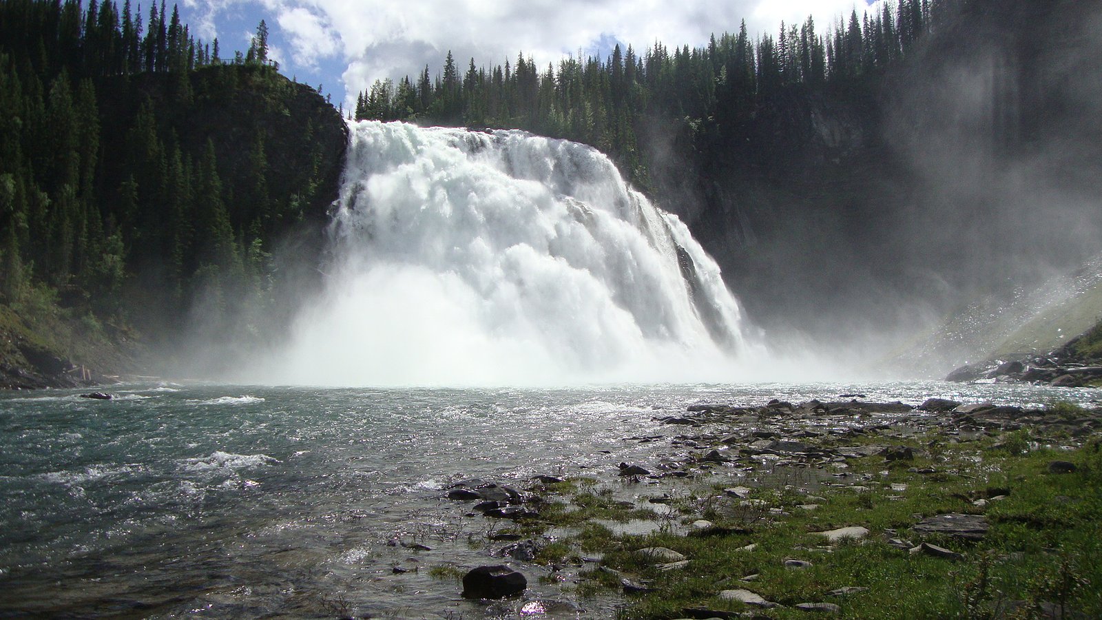
Canary Falls is a little-documented waterfall in remote northern British Columbia near coordinates 54.7718, -121.1716. Public information is limited; the falls appear to be in a backcountry setting accessed by forest or logging roads and unmaintained trails. Flow is likely highest in spring during snowmelt and lower later in summer. Specifics about the type of falls and exact height are not well recorded and may vary seasonally.
The Setting
Canary Falls sits at 883 metres within Monkman Park, in the hills of British Columbia.
Why This Waterfall Exists
Canary Falls flows over Sulphur Mountain Formation, a layered sedimentary rock layer deposited about 201-237 million years ago. These soft rocks erode readily, allowing the stream to carve a vertical drop into the landscape.
Nearby Falls Worth Visiting
Kinuseo Falls (60 m) lies 1.8 kilometres to the northwest. Also nearby: Babcock Falls (8 m, 20.3 km).
Trail & Hike Details
Trail Description
There is no widely published, maintained trail description for Canary Falls. Reaching the falls may involve driving on remote gravel roads followed by an unmarked footpath or cross-country travel. Routefinding skills and navigation with map/GPS are likely required. Trails, if present, may be short but rough; expect uneven terrain, brush, and possible stream crossings.
What to Expect
A remote, natural waterfall setting with limited visitor infrastructure. Expect variable flow depending on season (peak in spring). Terrain near the falls may include rocky banks, wet and mossy surfaces, steep or slippery approaches, and dense vegetation. Wildlife common to northern BC (bears, moose, etc.) may be present. Cell reception is likely unreliable.
Accessibility
The trail is not wheelchair accessible. Uneven terrain and elevation changes require steady footing.
Frequently Asked Questions
🐶 Are Dogs Allowed at Canary Falls?
❌ Dogs are not allowed
Are There Any Fees or Permits Required?
🆖 No fees required
🏊 Is There Swimming at Canary Falls?
❌ Swimming is not allowed
When to Visit
Late spring to early summer for highest water flow and generally passable roads. Mid to late summer may offer drier road conditions but lower flows. Fall can provide color and fewer insects but watch for early snowfall. Winter access is likely difficult or dangerous due to snow and ice unless you are equipped and experienced for winter travel.
Seasonal Access
The best time to visit is Spring, Summer, Fall, and Winter. Check with Monkman Park for current conditions.
Safety Information
Hazards include: remote location with limited cell reception; unstable, steep, or slippery banks and rock near the falls; cold, fast-moving water; seasonal road and trail closures or poor conditions; wildlife encounters (bears, moose); and rapidly changing weather. Prepare for self-rescue and extended delays, carry navigation and emergency communication tools, travel with a partner when possible, and inform someone of your plans.
Current Water Conditions
Based on a Water Survey of Canada gauge 33.7 km away
112.0 m³/s
Current discharge — how much water is flowing
About average for this time of year
Based on 48 years of record
1.79 m
Water depth at gauge
7-Day Discharge Trend
What does this mean for your visit?
Flow is about average for this time of year.
About This Gauge
This gauge is on a regional waterway. Conditions at the falls may differ, especially after local rain.
7-Day Flow Outlook
Based on the WSC gauge MURRAY RIVER ABOVE WOLVERINE RIVER (34 km away).
Today
Strong
120 m³/s
8/10Tomorrow
Strong
130 m³/s
8/10Tue
Moderate
117 m³/s
8/10Wed
Moderate
106 m³/s
8/10Thu
Moderate
108 m³/s
8/10Fri
Moderate
104 m³/s
8/10Sat
Moderate
108 m³/s
8/10Best window: Today — strong flow, rain showers (trip score 8/10).
Best time of year: this gauge typically runs highest from early May to late July, peaking in June.
How we calculate this
This is a transparent outlook, not a precise forecast. We take the waterfall's current flow strength (how it ranks against its historical normal for today, from the nearest WSC stream gauge), carry that ranking forward along the gauge's seasonal curve, and nudge it for forecast rain. Confidence is highest for the next day or two and falls further out. Always check official conditions and your own judgment before visiting — high flows can be dangerous.
Weather Forecast
Location & Access
Getting There
The falls are in a remote area of northern British Columbia. Access is typically via unpaved forest service or logging roads and may require a high-clearance 4x4. There do not appear to be formal signed trailheads in widely distributed guidebooks; visitors should consult current topographic maps, recent trip reports, and local resource/visitor centres before attempting access. Expect limited or no cell coverage.
Get Directions on Google MapsParking
No formal parking facilities are known; parking is likely limited to roadside pullouts on logging or forest service roads. Park clear of traffic and private gates and follow posted signage.
Elevation
883 metres above sea level
Coordinates
54.771771° N, -121.171642° W
Land Management
Managed by Government of British Columbia
Visitor Tips & Gear
1) Consult recent trip reports, local visitor centres, or regional forest service offices for current road and trail conditions before you go. 2) Use a detailed topo map and GPS; know your route and turnaround time. 3) Bring bear spray and know how to use it; make noise and store food properly. 4) Wear sturdy waterproof boots; expect slippery rocks and wet approaches. 5) Travel with a partner if possible and leave your trip plan with someone. 6) Respect private property and posted closures; many access roads in this region cross active forestry areas.
Where to Stay
Browse vacation cabins and private rentals nearby
Unique outdoor stays — tents, yurts, and treehouses
Rent a campervan or RV for your waterfall road trip
Some links are affiliate links. We may earn a commission at no extra cost to you.
Nearby Campground
Kinuseo Falls Campground
2.2 km away
Additional Information
Nearby Attractions
This is a backcountry region with lakes, rivers, and potential fishing and hiking opportunities. Specific nearby named attractions are not well-documented for this exact coordinate, check regional tourism resources or maps for additional points of interest.
Wildlife
Bears (black and possibly grizzly), moose, wolves, cougars, small mammals, and many bird species. Insect activity (mosquitoes, black flies) can be heavy in warmer months.
Nearby Waterfalls
Writing about Canary Falls? Embed this waterfall on your site for free.