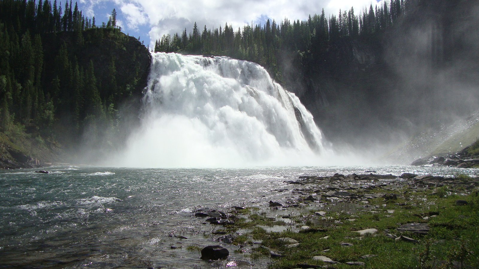
Babcock Falls
British Columbia • 8 m
By Armen Suny · Last verified Jun 2026
Difficulty
Moderate
Trail Length
2.3 km
Trail Type
Out And Back
Elevation Gain
54 m
About Babcock Falls
Babcock Falls is a forested, likely multi-step cascade set in a remote portion of central British Columbia (approx. coordinates 54.9077, -120.9619). The falls appear in a heavily-forested landscape, where access is likely via logging or secondary forestry roads and a short unmaintained trail or creekside scramble. Precise, authoritative published information about the falls (official park page, trail guide, or measured height) is limited, visitors should plan for a remote, low-service visit and check local land managers before traveling.
The Setting
Babcock Falls sits at 1,311 metres in the mountains of British Columbia. The falls drop 8 metres.
Why This Waterfall Exists
Babcock Falls flows over layered sedimentary rock, primarily sandstone, laid down about 66-101 million years ago. These soft rocks erode readily, allowing the stream to carve a 26-foot drop into the landscape.
Nearby Falls Worth Visiting
Kinuseo Falls (60 m) lies 20.1 kilometres to the southwest.
Trail & Hike Details
The Approach
The moderate 2.3-km out-and-back trail gains 54 metres of elevation on the way to the falls.
Trail Description
Publicly-available trail descriptions appear limited or informal. Access likely involves following a short unmaintained path or bushwhack from a logging road or pullout to the creek; expect inconsistent signage and route-finding challenges. Trails may be steep and muddy near the water with exposed roots and loose rock. Because of limited documentation, treat the route as unmarked and plan accordingly.
What to Expect
The falls drop 8 metres over soft fine-grained rock.
Accessibility
The trail is not wheelchair accessible. Uneven terrain and elevation changes require steady footing.
Frequently Asked Questions
🐶 Are Dogs Allowed at Babcock Falls?
❌ Dogs are not allowed
Are There Any Fees or Permits Required?
🆖 No fees required
🏊 Is There Swimming at Babcock Falls?
❌ Swimming is not allowed
When to Visit
Late spring to early summer for the highest flows and best photographic conditions; early fall for lower flows and fall color. Avoid visiting after heavy rains or during freeze-thaw periods when banks and rocks become especially slippery. Winter visits are possible but can be hazardous (ice, deep snow, and very limited access).
Seasonal Access
The best time to visit is Spring, Summer, and Fall. Winter access may be limited. Check with the managing park or local authority for current conditions.
Safety Information
Hazards: slippery and unstable rocks near the water; steep drop-offs; rapidly changing water flow after heavy rain or snowmelt; poor or no cell service; remote location which can complicate emergency response. Roads may be rough, gated, or seasonally closed. There may be active logging in the area, respect closures and signage. Carry navigation aids, tell someone your route and estimated return time, and be prepared to turn back if conditions are unsafe.
Current Water Conditions
111.0 m³/s
Current discharge — how much water is flowing
About average for this time of year
Based on 48 years of record
1.78 m
Water depth at gauge
7-Day Discharge Trend
What does this mean for your visit?
Flow is about average for this time of year.
About This Gauge
This gauge is on a nearby waterway and may not reflect exact conditions at the falls.
7-Day Flow Outlook
Based on the WSC gauge MURRAY RIVER ABOVE WOLVERINE RIVER (17 km away).
Today
Strong
120 m³/s
8/10Tomorrow
Strong
130 m³/s
8/10Tue
Strong
126 m³/s
8/10Wed
Moderate
111 m³/s
8/10Thu
Moderate
108 m³/s
8/10Fri
Moderate
104 m³/s
8/10Sat
Moderate
108 m³/s
8/10Best window: Today — strong flow, rain showers (trip score 8/10).
Best time of year: this gauge typically runs highest from early May to late July, peaking in June.
How we calculate this
This is a transparent outlook, not a precise forecast. We take the waterfall's current flow strength (how it ranks against its historical normal for today, from the nearest WSC stream gauge), carry that ranking forward along the gauge's seasonal curve, and nudge it for forecast rain. Confidence is highest for the next day or two and falls further out. Always check official conditions and your own judgment before visiting — high flows can be dangerous.
Weather Forecast
Location & Access
Getting There
The falls are in a remote part of central BC. Expect to reach the general area via paved highways to the nearest service town followed by secondary or forest/logging roads. Roads may be rough and could require high-clearance or 4x4 vehicles. Exact public access routes and parking locations are not well-documented, confirm current road conditions and access with local regional district, forestry office, or BC Parks before you go.
Get Directions on Google MapsParking
No formal parking lot is known to be provided. Parking is likely informal along a forestry road or at a pullout; use caution and avoid blocking gates or access roads. If unsure, park in a safe, designated area in the nearest town and ask for local advice.
Elevation
1,311 metres above sea level
Coordinates
54.907663° N, -120.961865° W
Visitor Tips & Gear
• Check current road and access conditions with local regional district, forestry office, or BC Parks before visiting. • Use a high-clearance vehicle if driving forest roads; consider leaving low-clearance vehicles in the nearest service town if conditions are poor. • Wear sturdy, waterproof footwear with good traction; approach rock edges with caution. • Carry bear spray and know how to use it; make noise on approach and store food securely. • Leave no trace: pack out all garbage and avoid disturbing vegetation and stream banks. • If uncertain about route-finding, visit with someone experienced or hire a local guide.
As an Amazon Associate, we earn from qualifying purchases.
With 2.3 km and 54 m of elevation gain, sturdy boots and trekking poles will help on this moderate trail. Sun exposure on the trail makes good sun protection a must in summer.

Columbia Watertight II Rain Jacket
Packs into its own pocket, seam-sealed, and keeps you dry from spray and surprise rain.

Earth Pak Waterproof Dry Bag
Keeps your phone and gear dry when waterfall mist soaks everything else.

Waterproof Phone Pouch (AiRunTech)
Cheap insurance — take photos right next to the falls without killing your phone.

Timberland Euro Sprint Mid Waterproof
Trusted waterproof boot with premium leather and grippy rubber sole — reliable on rocky, wet trails.

TrailBuddy Trekking Poles
Lightweight aluminum, cork grips, and flip-locks that actually hold — a best-seller for good reason.

Polarized Sunglasses (Knockaround)
Cuts glare off the water so you actually see the falls — and your photos turn out better too.
Where to Stay
Browse vacation cabins and private rentals nearby
Unique outdoor stays — tents, yurts, and treehouses
Rent a campervan or RV for your waterfall road trip
Some links are affiliate links. We may earn a commission at no extra cost to you.
Nearby Campground
Free camping
11.9 km away
Additional Information
Nearby Attractions
Because published information on this specific falls is limited, nearby attractions are not confidently known. Visitors should consult local tourism offices or regional visitor maps for other waterfalls, provincial parks, trails, or lakes in the broader region near the provided coordinates.
Wildlife
Black bears, grizzly bears (in some parts of central BC), moose, deer, wolves, small mammals, waterfowl, and a variety of songbirds. Ticks can be present in some seasons. Use standard wildlife precautions.
Nearby Waterfalls
Writing about Babcock Falls? Embed this waterfall on your site for free.