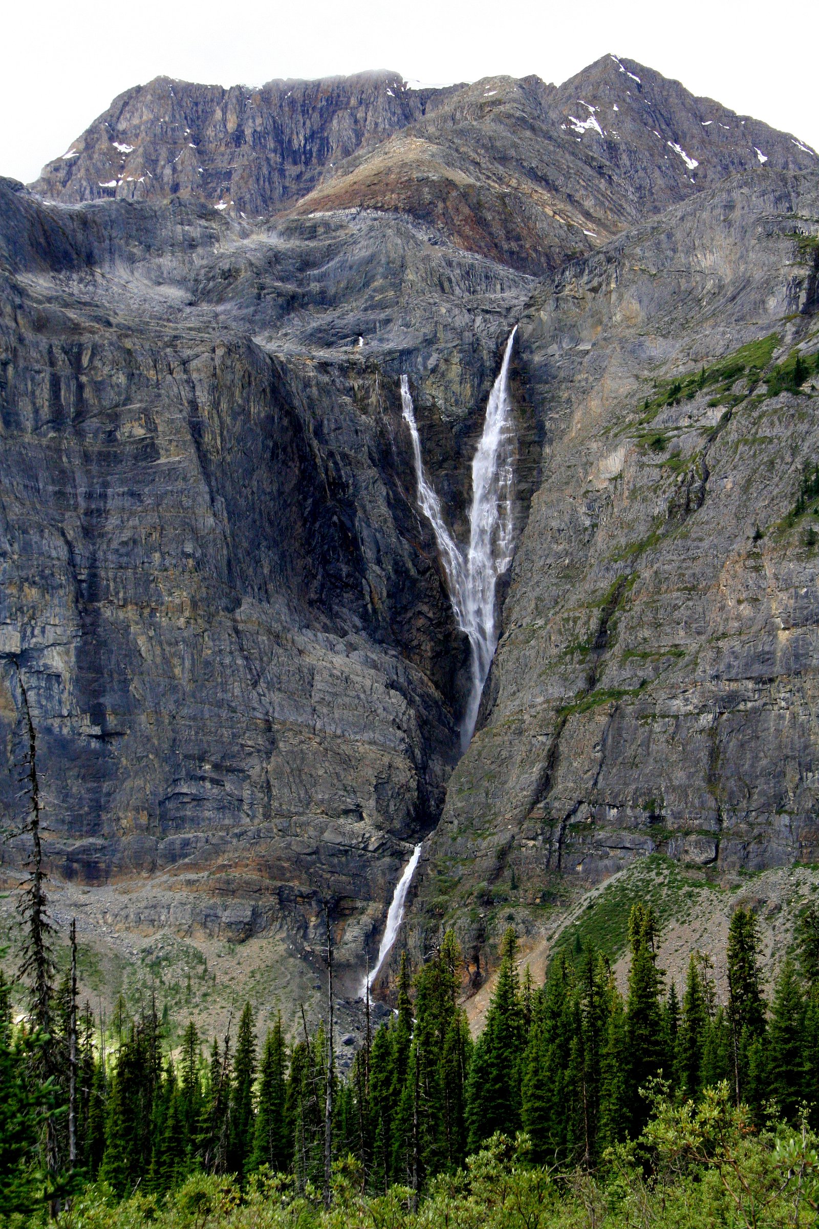
Helmet Falls
British Columbia • Kootenay National Park • 352 m
By Armen Suny · Last verified Jun 2026
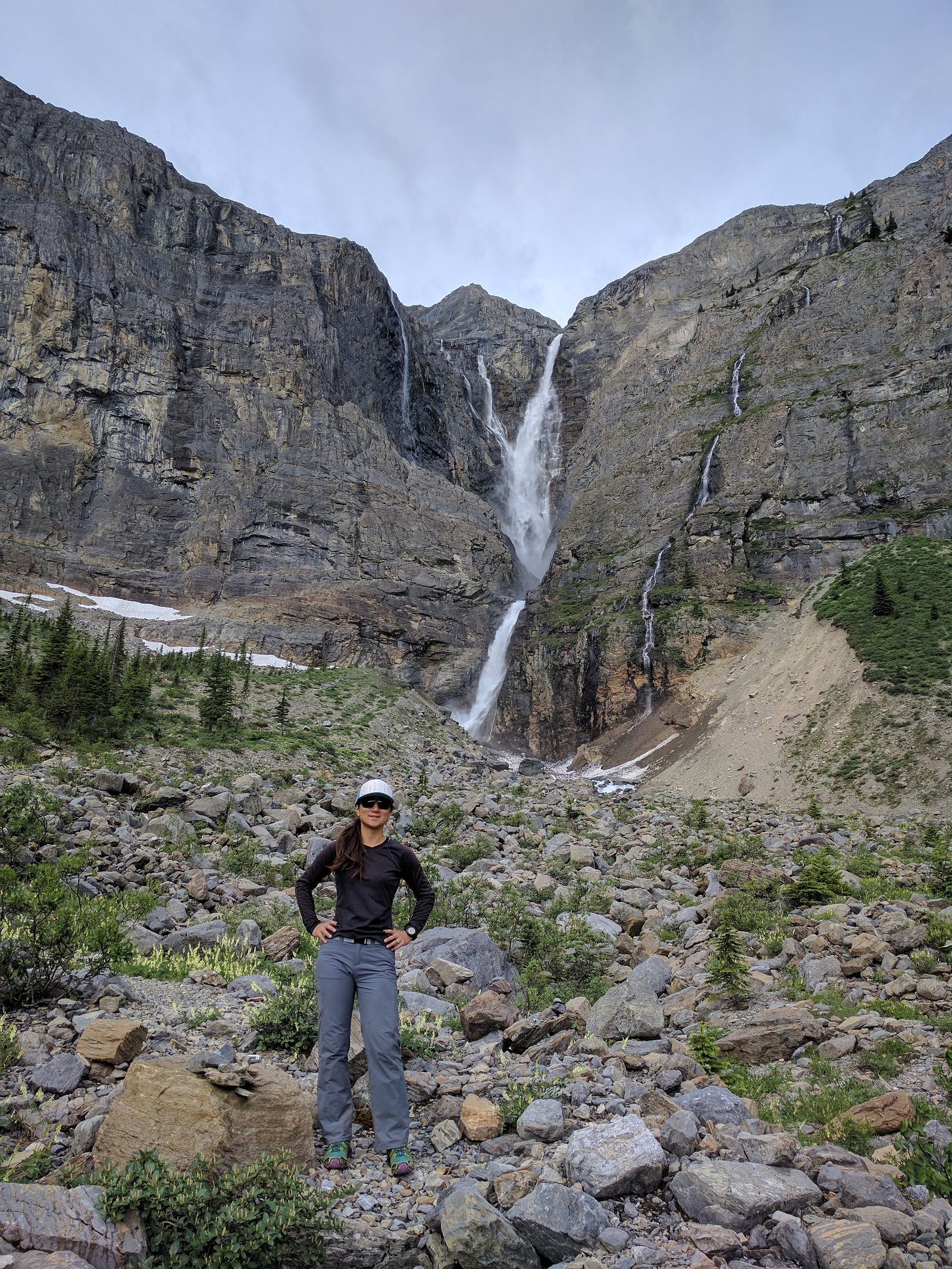
Photo Credits (2)
Difficulty
Hard
Trail Length
28.3 km
Trail Type
Out And Back
Elevation Gain
770 m
About Helmet Falls
Helmet Falls is a tiered waterfall located in Kootenay National Park in British Columbia, Canada. With total height of 352 metres (1,155 ft), Helmet Falls is the 11th tallest confirmed waterfall in the Canadian Rockies, as well as one of the most significant waterfalls in British Columbia based on both height and volume.
The Setting
Helmet Falls sits at 2,287 metres within Kootenay National Park, in the high mountains of British Columbia. At 352 metres, it is among the taller waterfalls in British Columbia.
Why This Waterfall Exists
Helmet Falls flows over layered sedimentary rock laid down about 485-539 million years ago. Over time, the stream has worn through these layers at different rates, creating a 1155-foot drop that forms the waterfall.
Trail & Hike Details
The Approach
The hard 28.3-km out-and-back trail gains 770 metres of elevation on the way to the falls.
Trail Description
Route descriptions vary between trip reports. Approaches typically traverse alpine meadows, moraines, and rocky talus; wayfinding can be required on lesser-used sections. Trails may be exposed and include steep switchbacks and creek/stream crossings. If following an established trail, it may be a long out-and-back hike into the cirque above the falls. Trail conditions are highly seasonal, early season routes may be snow-covered and late season may have high-vegetation or creek-swollen crossings.
What to Expect
The falls plunge a dramatic 352 metres over layered sedimentary rock.
Accessibility
The trail involves steep, uneven terrain with significant elevation change and is not accessible to mobility devices.
Frequently Asked Questions
🐶 Are Dogs Allowed at Helmet Falls?
❌ Dogs are not allowed
Are There Any Fees or Permits Required?
🆖 No fees required
🏊 Is There Swimming at Helmet Falls?
❌ Swimming is not allowed
When to Visit
Late spring through early summer for peak flow (snowmelt). Summer and early fall offer the most reliable trail access. Winter access may be possible with snowshoes or skis but requires winter backcountry experience and appropriate safety gear; snow can obscure route-finding and increase objective hazards.
Seasonal Access
The best time to visit is Spring, Summer, and Fall. Access roads and trails may close during winter due to snow. Check with Kootenay National Park for current conditions.
Safety Information
Potential hazards include: slippery rocks and cliffs near the falls, seasonal high water and strong currents, unstable talus and scree slopes, sudden weather changes and thunderstorms, snowfields early/late season, vehicle/road closures to access trailheads, and encounter with wildlife (including bears). Carry appropriate navigation, communication, and emergency gear and inform someone of your plans. For winter travel, avalanche risk and cold exposure are additional serious hazards.
Current Water Conditions
Based on a Water Survey of Canada gauge 28.5 km away
38.2 m³/s
Current discharge — how much water is flowing
Higher than usual for this time of year
Based on 70 years of record
1.94 m
Water depth at gauge
7-Day Discharge Trend
What does this mean for your visit?
The water is flowing higher than usual for this time of year.
About This Gauge
This gauge is on a regional waterway. Conditions at the falls may differ, especially after local rain.
7-Day Flow Outlook
Based on the WSC gauge BOW RIVER AT LAKE LOUISE (28 km away).
Today
Strong
38 m³/s
10/10Tomorrow
Strong
38 m³/s
9/10Tue
Strong
38 m³/s
9/10Wed
Strong
38 m³/s
9/10Thu
Strong
41 m³/s
8/10Fri
Roaring
41 m³/s
6/10Sat
Strong
39 m³/s
9/10Best window: Today — strong flow, mainly sunny (trip score 10/10).
Best time of year: this gauge typically runs highest from late May to late August, peaking in July.
How we calculate this
This is a transparent outlook, not a precise forecast. We take the waterfall's current flow strength (how it ranks against its historical normal for today, from the nearest WSC stream gauge), carry that ranking forward along the gauge's seasonal curve, and nudge it for forecast rain. Confidence is highest for the next day or two and falls further out. Always check official conditions and your own judgment before visiting — high flows can be dangerous.
Know when to go.
Get a free email alert when waterfalls near Lake Louise hit peak flow. We only send when conditions are worth the trip — no weekly newsletters, no spam.
Weather Forecast
Location & Access
Getting There
General access is from alpine/backcountry trails in the Lake Louise / Yoho / Kootenay area. Approaches may require travel on forest or secondary roads to a trailhead and then a multi-kilometre hike into backcountry terrain. Exact trailheads and routes are not consistently documented in a single official source; check Parks Canada, AllTrails, and recent trip reports for the current recommended approach and road conditions. Expect sections of trail that may be steep, rocky, and involve stream crossings.
Get Directions on Google MapsParking
Parking is likely limited at the nearest trailhead; some approaches may start from small pullouts or designated parking for backcountry trails. Parking availability and overnight parking rules may change seasonally, verify with local park authorities before arriving.
Elevation
2,287 metres above sea level
Coordinates
51.186995° N, -116.323965° W
Land Management
Managed by Parks Canada Agency
Visitor Tips & Gear
• Check recent trip reports, AllTrails pages, and Parks Canada for route updates, road conditions, and closures before heading out. • Be prepared for alpine weather: layers, rain shell, and sun protection. • Carry a map, compass/GPS, and know how to navigate off-trail if needed. • Practice safe stream crossing techniques and avoid getting too close to the edge; wet rocks can be dangerously slippery. • If in bear country, carry bear spray and know how to use it; make noise on approach. • Leave no trace, pack out all garbage and avoid disturbing fragile alpine vegetation.
This trail sits at 7,503 ft above sea level
Elevated TrailUV radiation is roughly 30% stronger at this elevation than at sea level, and the dry air accelerates dehydration. Extra sun protection and fluids go a long way.
As an Amazon Associate, we earn from qualifying purchases.

Coppertone Sport SPF 50 Sunscreen
UV intensity jumps ~4% per 1,000 ft — at this elevation you can burn in half the time.

Sun Bum SPF 30 Lip Balm (3-Pack)
Lips have almost no natural UV protection and burn fast in thin, dry mountain air.

Liquid I.V. Electrolyte Packets
You lose moisture ~2x faster at elevation — electrolytes help you absorb water efficiently.

ROCKNIGHT Polarized UV400 Sunglasses
High-altitude glare off rock and water is intense — UV400 lenses block 99%+ of UVA/UVB.
As an Amazon Associate, we earn from qualifying purchases.
This challenging 28.3 km trail gains 770 m in elevation — come prepared with proper hiking boots and trekking poles. Sun exposure on the trail makes good sun protection a must in summer.

Sawyer Squeeze Water Filter
The backcountry standard — filters 99.9% of bacteria and weighs just 3 oz.

Polarized Sunglasses (Knockaround)
Cuts glare off the water so you actually see the falls — and your photos turn out better too.

Columbia Watertight II Rain Jacket
Packs into its own pocket, seam-sealed, and keeps you dry from spray and surprise rain.

Earth Pak Waterproof Dry Bag
Keeps your phone and gear dry when waterfall mist soaks everything else.

Waterproof Phone Pouch (AiRunTech)
Cheap insurance — take photos right next to the falls without killing your phone.

Timberland Euro Sprint Mid Waterproof
Trusted waterproof boot with premium leather and grippy rubber sole — reliable on rocky, wet trails.
Where to Stay
Browse vacation cabins and private rentals nearby
Unique outdoor stays — tents, yurts, and treehouses
Rent a campervan or RV for your waterfall road trip
Some links are affiliate links. We may earn a commission at no extra cost to you.
Nearby Campground
Helmet Falls
1.6 km away
Additional Information
Nearby Attractions
Lake Louise, Moraine Lake, Icefields Parkway scenic areas, Yoho National Park attractions (depending on exact location), and other alpine hikes and lakes in the Lake Louise/Banff region. Confirm distances and access routes from your starting point.
Wildlife
Standard alpine/backcountry wildlife: mountain goats, elk, deer, black and possibly grizzly bears, small mammals, and raptors. Maintain a safe distance from wildlife and follow Parks Canada guidance for bear safety and wildlife encounters.
Cities near Helmet Falls
Nearby Waterfalls
Writing about Helmet Falls? Embed this waterfall on your site for free.