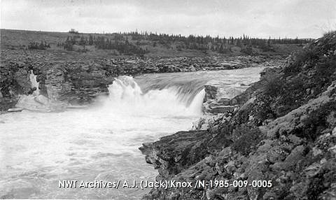
Macdonald Falls
Northwest Territories • 18 m
By Armen Suny · Last verified Jun 2026
Photo Credits (3)
Difficulty
Hard
About Macdonald Falls
Macdonald Falls is a remote waterfall in the Northwest Territories at the given coordinates. Precise published information on the waterfall (official name usage, measured height, or developed visitor infrastructure) appears limited. The falls are in a sparsely populated, boreal/wilderness region and may be reached only by extended overland travel, river travel, or aircraft. Visitors should expect a natural, undeveloped site with little to no facilities.
The Setting
Macdonald Falls sits at 220 metres within Thelon Wildlife Sanctuary, in the foothills of Northwest Territories. The falls drop 18 metres.
Why This Waterfall Exists
Macdonald Falls flows over layered sedimentary rock laid down over 1.0-2.5 billion years ago. Over time, the stream has worn through these layers at different rates, creating a 60-foot drop that forms the waterfall.
Trail & Hike Details
Trail Description
There is no well-documented maintained trail to Macdonald Falls in public trail databases that this summary can confirm. Expect rough route-finding, muskeg, river valleys, and possibly steep or slick rock near the falls. Approach may require river travel, portage, bushwhacking, or aircraft drop-off and pickup. Because official trail data is not available, details such as exact route length, technical grade, and established trailheads are not provided here.
What to Expect
The falls drop 18 metres over layered sedimentary rock.
Accessibility
The trail involves steep, uneven terrain with significant elevation change and is not accessible to mobility devices.
Frequently Asked Questions
🐶 Are Dogs Allowed at Macdonald Falls?
❌ Dogs are not allowed
Are There Any Fees or Permits Required?
🆖 No fees required
🏊 Is There Swimming at Macdonald Falls?
❌ Swimming is not allowed
When to Visit
Late spring to early summer (after ice breakup) for highest flow and dramatic water levels. Late summer can offer easier access by canoe or floatplane and fewer insects later in the season. Winter access (over-ice/snow) is possible for experienced winter travelers but presents significant hazards; only attempt with appropriate training and equipment.
Seasonal Access
The best time to visit is Spring, Summer, and Fall. Winter access may be limited. Check with the managing park or local authority for current conditions.
Safety Information
This is a remote wilderness location. Major hazards include: rapid weather changes, hypothermia risk from cold water and wind, slippery rock and steep drop-offs near the falls, strong currents and undertows, difficult river crossings, mosquito/blackfly season, and wildlife encounters (including bears). Emergency services will likely be distant and slow to reach the site. Carry a satellite communicator or PLB and sufficient emergency gear. If planning aircraft access, coordinate precisely with the pilot and have contingency plans for delays.
Current Water Conditions
Based on a Water Survey of Canada gauge 26.5 km away
31.4 m³/s
Current discharge — how much water is flowing
Much lower than usual for this time of year
Based on 42 years of record
4.91 m
Water depth at gauge
7-Day Discharge Trend
What does this mean for your visit?
Flow is well below normal for this time of year, so the waterfall may be a trickle.
About This Gauge
This gauge is on a regional waterway. Conditions at the falls may differ, especially after local rain.
7-Day Flow Outlook
Based on the WSC gauge HANBURY RIVER ABOVE HOARE LAKE (27 km away).
Today
Barely Flowing
34 m³/s
3/10Tomorrow
Barely Flowing
32 m³/s
4/10Tue
Barely Flowing
32 m³/s
3/10Wed
Low
33 m³/s
4/10Thu
Barely Flowing
31 m³/s
4/10Fri
Barely Flowing
31 m³/s
3/10Sat
Barely Flowing
29 m³/s
4/10Best window: Tomorrow — barely flowing flow, cloudy (trip score 4/10).
Best time of year: this gauge typically runs highest from early June to early September, peaking in June.
How we calculate this
This is a transparent outlook, not a precise forecast. We take the waterfall's current flow strength (how it ranks against its historical normal for today, from the nearest WSC stream gauge), carry that ranking forward along the gauge's seasonal curve, and nudge it for forecast rain. Confidence is highest for the next day or two and falls further out. Always check official conditions and your own judgment before visiting — high flows can be dangerous.
Weather Forecast
Location & Access
Getting There
The site is in a remote portion of the Northwest Territories. There is likely no maintained road access directly to the falls. Access methods that may be required include floatplane, bush plane, multi-day canoe/kayak or river travel, or long off-trail hiking. Approach details and travel times are not well-documented publicly and will depend on starting point and season. Cell coverage is likely unreliable or absent.
Get Directions on Google MapsParking
No developed parking or facilities are known at the coordinates. If a nearby informal landing/parking area exists it would likely be unimproved. Plan for remote-vehicle or aircraft operations and consult local authorities or outfitters.
Elevation
220 metres above sea level
Coordinates
63.734255° N, -104.724815° W
Land Management
Managed by Government of the Northwest Territories
Visitor Tips & Gear
1) Treat this as a remote backcountry trip, plan and prepare accordingly. 2) Hire an experienced local guide or charter a bush/floatplane if you are unfamiliar with remote Northwest Territories travel. 3) File a trip plan with someone and carry a satellite communicator or PLB. 4) Be bear-aware: carry bear spray and know how to store food properly. 5) Check river conditions and local authorities for any recent access advisories. 6) Practice Leave No Trace; pack out all waste. 7) Avoid getting close to the edge of the falls, rocks are often slippery and currents strong.
Where to Stay
Browse vacation cabins and private rentals nearby
Unique outdoor stays — tents, yurts, and treehouses
Rent a campervan or RV for your waterfall road trip
Some links are affiliate links. We may earn a commission at no extra cost to you.
Additional Information
Nearby Attractions
No well-known, developed tourist attractions are documented immediately at the coordinates. Other wilderness river corridors, lakes, and remote natural features are typical in the region; local outfitters or territorial tourism offices may identify nearby points of interest.
Wildlife
Typical boreal and subarctic wildlife: black and possibly grizzly bears, moose, wolves, beavers, migratory birds, and abundant insects (mosquitoes/blackflies) in summer. Take standard precautions for large mammals and insects.
Nearby Waterfalls
Writing about Macdonald Falls? Embed this waterfall on your site for free.