Difficulty
Moderate
Trail Length
6.5 km
Trail Type
Out And Back
Elevation Gain
260 m
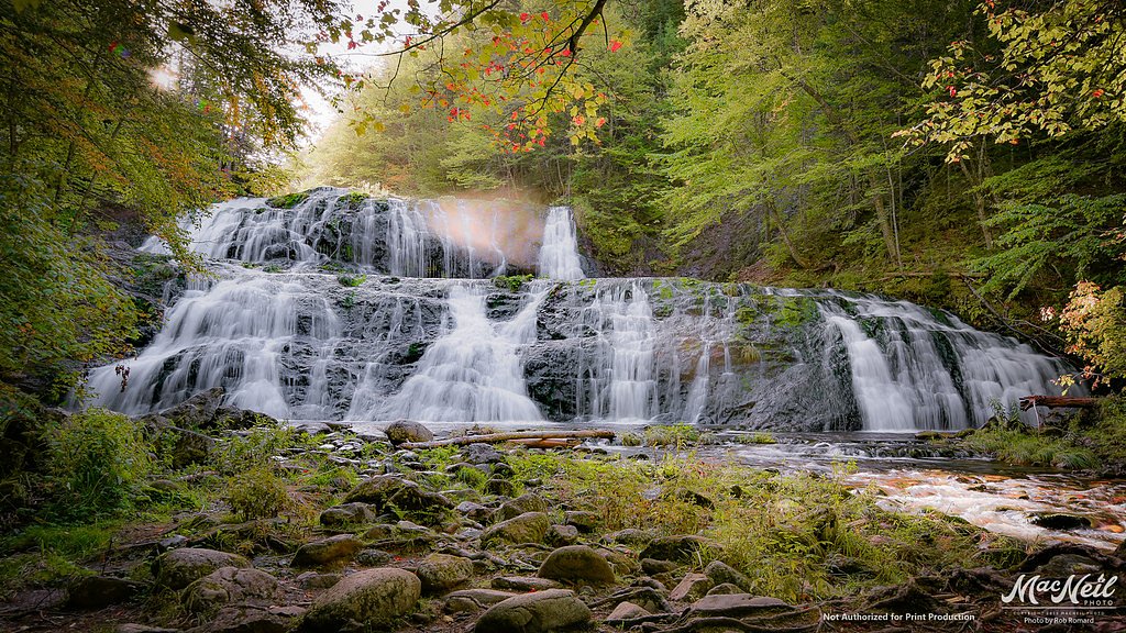
About Gerlock Falls
Gerlock Falls is a little-known waterfall on Cape Breton Island near Baddeck, Nova Scotia (coordinates 46.1223, -60.9776). It is not a major tourist site and appears to be a relatively small cascade or series of drops rather than a large single plunge. Published, detailed information is limited; the falls may sit on or be reached via forest/undeveloped land and are not widely signed or serviced. Visitors should expect limited infrastructure and limited official information about the feature.
Nearby Falls Worth Visiting
Uisge Ban Falls, the tallest waterfall in Nova Scotia at 101 metres, lies 17.5 kilometres to the northeast. Also nearby: Egypt Falls (18 m, 13.8 km).
Trail & Hike Details
The Approach
The moderate 6.5-km out-and-back trail gains 260 metres of elevation on the way to the falls.
Trail Description
There is little published, maintained trail information. Reaching the falls may require travel on unmaintained forestry roads and a short off-trail scramble through mixed woods and uneven terrain. Expect steep, eroded or muddy sections near the stream and no formal steps, railings, or signage. Trail conditions may change rapidly after storms or logging activity.
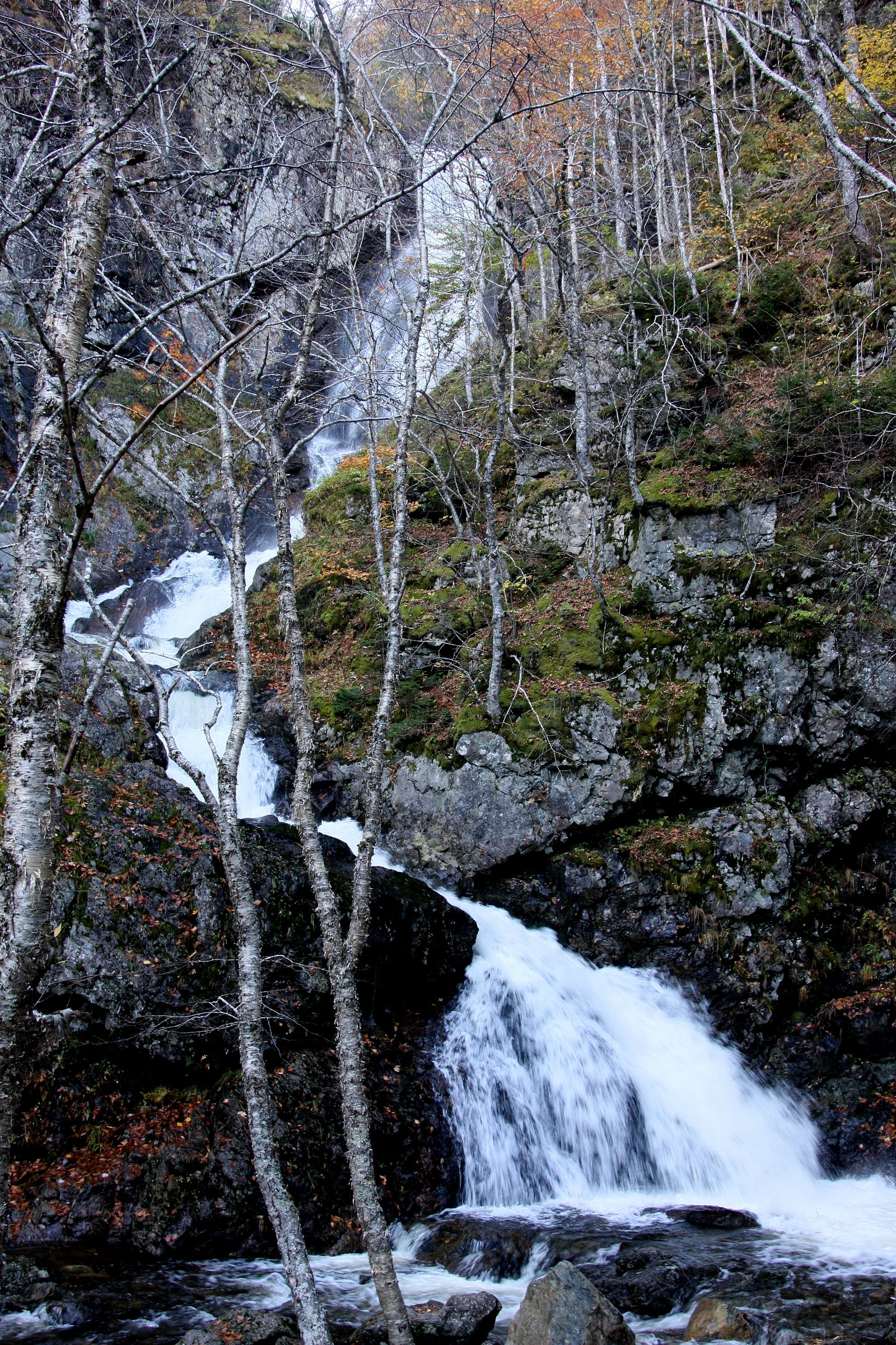
What to Expect
A modest, natural waterfall in a forested setting with moss-covered rocks and variable flow depending on season and recent precipitation. Spring melt and heavy rains produce the highest flows; summer may be lower. No amenities (restrooms, picnic tables, interpretive signs). Insects (black flies, mosquitoes) are common in warmer months; ticks may be present. Cell service may be limited in parts.
Accessibility
The trail is not wheelchair accessible. Uneven terrain and elevation changes require steady footing.
Frequently Asked Questions
🐶 Are Dogs Allowed at Gerlock Falls?
❌ Dogs are not allowed
Are There Any Fees or Permits Required?
🆖 No fees required
🏊 Is There Swimming at Gerlock Falls?
❌ Swimming is not allowed
When to Visit
Spring (high water) and fall (autumn colors) are best for scenic views and stronger flows. Summer offers easier access but lower water levels and more insects. Winter may create ice formations but is potentially hazardous without proper equipment, approach with caution or avoid.
Seasonal Access
The best time to visit is Spring, Summer, Fall, and Winter. Check with the managing park or local authority for current conditions.
Safety Information
Primary hazards include slippery and unstable rock near the falls, steep or eroded banks, cold water and strong currents during high flows, limited or no cellphone reception, and seasonal insects and ticks. There may also be hazards related to private property, active logging operations, or poorly maintained forest roads. Always check local conditions, obtain permission where required, wear appropriate footwear, and avoid cliff edges and fast-flowing water.
Current Water Conditions
2.2 m³/s
Current discharge — how much water is flowing
Higher than usual for this time of year
Based on 21 years of record
1.06 m
Water depth at gauge
7-Day Discharge Trend
What does this mean for your visit?
The water is flowing higher than usual for this time of year.
About This Gauge
7-Day Flow Outlook
Based on the WSC gauge MIDDLE RIVER AT MACLENNANS CROSS (8 km away).
Today
Roaring
2.5 m³/s
6/10Tomorrow
Roaring
2.4 m³/s
6/10Tue
Strong
2.2 m³/s
9/10Wed
Roaring
2.9 m³/s
6/10Thu
Roaring
3.3 m³/s
6/10Fri
Roaring
2.7 m³/s
6/10Sat
Strong
2.7 m³/s
8/10Best window: Tue — strong flow, cloudy (trip score 9/10).
Best time of year: this gauge typically runs highest from early April to late May, peaking in April.
How we calculate this
This is a transparent outlook, not a precise forecast. We take the waterfall's current flow strength (how it ranks against its historical normal for today, from the nearest WSC stream gauge), carry that ranking forward along the gauge's seasonal curve, and nudge it for forecast rain. Confidence is highest for the next day or two and falls further out. Always check official conditions and your own judgment before visiting — high flows can be dangerous.
Know when to go.
Get a free email alert when waterfalls near Baddeck hit peak flow. We only send when conditions are worth the trip — no weekly newsletters, no spam.
Weather Forecast
Location & Access
Getting There
General access is from local roads off the main highways around Baddeck and Cape Breton. The falls lie about 10.7 miles from Baddeck, ~35.7 miles from Sydney and ~66.5 miles from Antigonish (straight-line/approximate driving distances provided). Access may require travel on gravel or logging roads and a short unmarked trail or bushwhack to the water; some approaches may cross private or leased forestry land. Check local maps, contact local tourism/landowners, and confirm access before visiting.
Get Directions on Google MapsParking
There is likely no formal parking lot or facilities. Expect roadside pullouts or informal turnouts on forestry or gravel roads. Park well off the travel surface and avoid blocking gates or driveways. If access is across private property, obtain permission and follow signage.
Elevation
164 metres above sea level
Coordinates
46.122273° N, -60.977644° W
Visitor Tips & Gear
1) Confirm land access and permission before visiting; parts of the approach may cross private or managed forestry land. 2) Wear sturdy, waterproof footwear with good traction, rocks and banks are slippery. 3) Bring insect repellent and check for ticks after leaving the area. 4) Avoid getting too close to the edge of drops; wet rock is very slippery. 5) Leave no trace, pack out what you bring. 6) Tell someone your route and expected return time if going off-trail.
As an Amazon Associate, we earn from qualifying purchases.
With 6.5 km and 260 m of elevation gain, sturdy boots and trekking poles will help on this moderate trail. Icy conditions are common in winter — traction cleats are a smart addition.

Columbia Watertight II Rain Jacket
Packs into its own pocket, seam-sealed, and keeps you dry from spray and surprise rain.

Earth Pak Waterproof Dry Bag
Keeps your phone and gear dry when waterfall mist soaks everything else.

Waterproof Phone Pouch (AiRunTech)
Cheap insurance — take photos right next to the falls without killing your phone.

Timberland Euro Sprint Mid Waterproof
Trusted waterproof boot with premium leather and grippy rubber sole — reliable on rocky, wet trails.

TrailBuddy Trekking Poles
Lightweight aluminum, cork grips, and flip-locks that actually hold — a best-seller for good reason.

Kahtoola MICROspikes
Cult-favorite traction cleats that grip ice and wet rock — essential for winter waterfall hikes.
Where to Stay
Browse vacation cabins and private rentals nearby
Unique outdoor stays — tents, yurts, and treehouses
Rent a campervan or RV for your waterfall road trip
Some links are affiliate links. We may earn a commission at no extra cost to you.
Nearby Campground
Baddeck Cabot Trail Campground
10.2 km away
Additional Information
Nearby Attractions
Baddeck and the Bras d'Or Lake area offer museums, scenic viewpoints, and cultural attractions. The broader Cape Breton region includes the Cabot Trail and multiple parks and lookouts; check local tourism resources for specifics.
Wildlife
Area wildlife may include deer, moose, black bear, small mammals, songbirds, and aquatic life. Insects such as black flies and mosquitoes are common in spring and summer; ticks are also a possibility. Observe wildlife from a distance and follow local guidance.
Cities near Gerlock Falls
Nearby Waterfalls
Writing about Gerlock Falls? Embed this waterfall on your site for free.