Egypt Falls
Nova Scotia • 18 m
By Armen Suny · Last verified Jun 2026
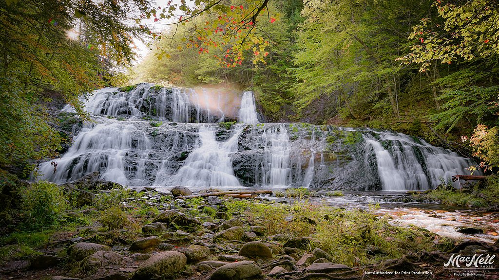

Photo Credits (4)
Difficulty
Moderate
Trail Length
1.8 km
Trail Type
Out And Back
Elevation Gain
109 m
About Egypt Falls
Egypt Falls (also seen as Egyptian Falls) is a scenic, forested waterfall in Nova Scotia. It sits in a rural, wooded landscape and is reached by a short hiking trail that may include uneven, rocky and sometimes steep terrain. Water flow is typically highest in spring and after heavy rain. Exact height and some access details vary by source and season; the description above may be approximate.
The Setting
Egypt Falls sits at 119 metres in the coastal lowlands of Nova Scotia. The falls drop 18 metres.
Why This Waterfall Exists
Egypt Falls flows over layered sedimentary rock laid down about 299-359 million years ago. Over time, the stream has worn through these layers at different rates, creating a 59-foot drop that forms the waterfall.
Trail & Hike Details
The Approach
The moderate 1.8-km out-and-back trail gains 109 metres of elevation on the way to the falls.
Trail Description
The trail to Egypt Falls typically travels through forested terrain and may include roots, rocks, muddy sections and short steep pitches. Near the falls the path can become narrow and slippery; reaching the base or the best viewpoints may require a short scramble. There are generally no built structures (railings, boardwalks) at the waterfall, and signage can be minimal or absent, so carry a map or use GPS.
What to Expect
The falls drop 18 metres over layered sedimentary rock.
Accessibility
The trail is not wheelchair accessible. Uneven terrain and elevation changes require steady footing.
Frequently Asked Questions
🐶 Are Dogs Allowed at Egypt Falls?
❌ Dogs are not allowed
Are There Any Fees or Permits Required?
🆖 No fees required
🏊 Is There Swimming at Egypt Falls?
❌ Swimming is not allowed
When to Visit
Spring (high water) and late spring/early summer for greenery; fall offers foliage colors. Winter access is possible for experienced snowshoers/ice climbers but can be hazardous and is not recommended without appropriate gear and local knowledge.
Seasonal Access
The best time to visit is Spring, Summer, and Fall. Winter access may be limited. Check with the managing park or local authority for current conditions.
Safety Information
Hazards include slippery rocks and trails, steep drop-offs near the falls, cold water temperatures, limited or no cell service in parts, and possible seasonal road closures or poor road conditions. There are likely no railings, posted warnings, or rescue services nearby. Always tell someone your plan, bring a charged phone, and exercise caution near water and edges.
Current Water Conditions
6.7 m³/s
Current discharge — how much water is flowing
Higher than usual for this time of year
Based on 106 years of record
0.89 m
Water depth at gauge
7-Day Discharge Trend
What does this mean for your visit?
The water is flowing higher than usual for this time of year.
About This Gauge
7-Day Flow Outlook
Based on the WSC gauge SOUTHWEST MARGAREE RIVER NEAR UPPER MARGAREE (3 km away).
Today
Strong
7.6 m³/s
7/10Tomorrow
Roaring
7.6 m³/s
6/10Tue
Strong
6.8 m³/s
9/10Wed
Strong
7.5 m³/s
8/10Thu
Strong
7.5 m³/s
8/10Fri
Strong
7.1 m³/s
8/10Sat
Strong
7.0 m³/s
8/10Best window: Tue — strong flow, cloudy (trip score 9/10).
Best time of year: this gauge typically runs highest from early April to late May, peaking in May.
How we calculate this
This is a transparent outlook, not a precise forecast. We take the waterfall's current flow strength (how it ranks against its historical normal for today, from the nearest WSC stream gauge), carry that ranking forward along the gauge's seasonal curve, and nudge it for forecast rain. Confidence is highest for the next day or two and falls further out. Always check official conditions and your own judgment before visiting — high flows can be dangerous.
Know when to go.
Get a free email alert when waterfalls near Baddeck hit peak flow. We only send when conditions are worth the trip — no weekly newsletters, no spam.
Weather Forecast
Location & Access
Getting There
The waterfall is located near coordinates 46.1931, -61.1255, roughly 20–25 miles from Baddeck, ~42–45 miles from Sydney and ~63–65 miles from Antigonish (distances vary by route). Expect to drive on local secondary and possibly unpaved roads to reach the trailhead; GPS coordinates or a reliable mapping app are recommended. Roads to the trailhead may be narrow, unpaved, and subject to seasonal conditions.
Get Directions on Google MapsParking
There is likely a small informal parking/pullout at or near the trailhead rather than a formal lot. Parking may be limited, park off the road where safe and legal, and avoid blocking gates or private driveways. During busy times space can fill quickly.
Elevation
119 metres above sea level
Coordinates
46.193100° N, -61.125495° W
Visitor Tips & Gear
1) Use GPS coordinates and recent trip reports to confirm the trailhead approach; logging roads or private roads may change access. 2) Wear sturdy, grippy footwear, rocks near the falls are slippery. 3) Bring insect repellent in summer and check for ticks. 4) Pack out all trash and follow Leave No Trace. 5) Avoid getting too close to edges or climbing on unstable rock. 6) If visiting after heavy rain, expect increased flow but also more slippery and hazardous conditions.
As an Amazon Associate, we earn from qualifying purchases.
With 1.8 km and 109 m of elevation gain, sturdy boots and trekking poles will help on this moderate trail. Sun exposure on the trail makes good sun protection a must in summer.

Polarized Sunglasses (Knockaround)
Cuts glare off the water so you actually see the falls — and your photos turn out better too.

Columbia Watertight II Rain Jacket
Packs into its own pocket, seam-sealed, and keeps you dry from spray and surprise rain.

Earth Pak Waterproof Dry Bag
Keeps your phone and gear dry when waterfall mist soaks everything else.

Waterproof Phone Pouch (AiRunTech)
Cheap insurance — take photos right next to the falls without killing your phone.

Timberland Euro Sprint Mid Waterproof
Trusted waterproof boot with premium leather and grippy rubber sole — reliable on rocky, wet trails.

TrailBuddy Trekking Poles
Lightweight aluminum, cork grips, and flip-locks that actually hold — a best-seller for good reason.
Where to Stay
Browse vacation cabins and private rentals nearby
Unique outdoor stays — tents, yurts, and treehouses
Rent a campervan or RV for your waterfall road trip
Some links are affiliate links. We may earn a commission at no extra cost to you.
Nearby Campground
MacKinnons Campground
11.3 km away
Additional Information
Nearby Attractions
Baddeck and the Bras d'Or Lake area (approx. 20 miles); scenic drives and other natural sites on Cape Breton Island. Exact nearby attractions depend on your route and starting point.
Wildlife
Typical regional wildlife includes white-tailed deer, small mammals, various songbirds, and occasional moose or black bear. Be aware of ticks in warm months.
Cities near Egypt Falls
Nearby Waterfalls
Writing about Egypt Falls? Embed this waterfall on your site for free.