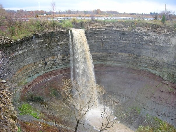
Dewitt Falls
Ontario • 10 m
By Armen Suny · Last verified Jun 2026
Difficulty
Drive Up
About Dewitt Falls
Dewitt Falls is one of the many small cascades tucked into the Niagara Escarpment near Hamilton, Ontario, a region famous for its concentration of waterfalls where escarpment geology creates ideal drop points. Though modest in scale, Dewitt Falls offers a pleasant, approachable scene for photographers and casual visitors who want a quick nature stop without a long backcountry trek. Many of Hamilton’s falls lie on or near the Bruce Trail, and Dewitt shares that same escarpment setting and easy-going character. According to available access data the site is classified as drive-up, so visitors should expect minimal hiking from roadside parking to a viewing spot. Because trail information for small, local falls is often limited, Dewitt Falls is best visited with modest expectations: short walk-in access, simple scenery, and a relaxed outing rather than a long hike or technical scramble.
The Setting
Dewitt Falls sits at 166 metres in the foothills of Ontario. The falls drop 10 metres.
Height: 32 feet
Nearby Falls Worth Visiting
Devil's Punchbowl Falls (37 m) lies 3.1 kilometres to the west. Also nearby: Vinemount East Falls (10 m, 2.6 km) and Vinemount West Falls (8 m, 2.4 km).
Trail & Hike Details
The Approach
No hiking required. Dewitt Falls is accessible by vehicle with a roadside viewing area.
Trail Description
Reliable, detailed trail descriptions are not readily verifiable for Dewitt Falls. Approaches to small regional waterfalls in the Hamilton/Niagara area are commonly short but can be on unmarked or minimally maintained footpaths with roots, rocks, and mud. Trails (if present) may be narrow, uneven, and involve short sections of descent to the stream bank. Expect limited or no formal trail signage and few built features (no boardwalks or railings unless the site is within an established conservation area).
What to Expect
The falls drop 10 metres.
Accessibility
This waterfall is viewable from a vehicle-accessible area. No hiking is required.
Frequently Asked Questions
🐶 Are Dogs Allowed at Dewitt Falls?
❌ Dogs are not allowed
Are There Any Fees or Permits Required?
🆖 No fees required
🏊 Is There Swimming at Dewitt Falls?
❌ Swimming is not allowed
When to Visit
Spring (late March–May) for highest flow from snowmelt and rain; early fall for pleasant temperatures and foliage. Winter can offer ice formations but is more hazardous due to ice and limited footing. Summer may have lower flows unless following rain.
Seasonal Access
The best time to visit is Spring, Summer, Fall, and Winter. Check with the managing park or local authority for current conditions.
Safety Information
Primary hazards: slippery and uneven terrain, steep or unstable banks, cold or fast-moving water after rain, falling from unprotected edges, and winter ice. Use caution near the water and avoid cliff edges. Tell someone your plan, carry a charged phone, and check weather forecasts. If the site is on or adjacent to private land, do not trespass.
Current Water Conditions
0.2 m³/s
Current discharge — how much water is flowing
About average for this time of year
Based on 40 years of record
11.27 m
Water depth at gauge
7-Day Discharge Trend
What does this mean for your visit?
Flow is about average for this time of year.
About This Gauge
7-Day Flow Outlook
Based on the WSC gauge REDHILL CREEK AT HAMILTON (6 km away).
Today
Moderate
0.2 m³/s
8/10Tomorrow
Moderate
0.2 m³/s
6/10Tue
Moderate
0.2 m³/s
6/10Wed
Moderate
0.2 m³/s
6/10Thu
Moderate
0.2 m³/s
8/10Fri
Moderate
0.2 m³/s
6/10Sat
Moderate
0.2 m³/s
6/10Best window: Today — moderate flow, mainly sunny (trip score 8/10).
Best time of year: this gauge typically runs highest from mid February to early May, peaking in April.
How we calculate this
This is a transparent outlook, not a precise forecast. We take the waterfall's current flow strength (how it ranks against its historical normal for today, from the nearest WSC stream gauge), carry that ranking forward along the gauge's seasonal curve, and nudge it for forecast rain. Confidence is highest for the next day or two and falls further out. Always check official conditions and your own judgment before visiting — high flows can be dangerous.
Know when to go.
Get a free email alert when waterfalls near Hamilton hit peak flow. We only send when conditions are worth the trip — no weekly newsletters, no spam.
Weather Forecast
Location & Access
Getting There
The waterfall is near 43.2067, -79.7184 and is roughly a 10–20 minute drive from the outskirts of Hamilton depending on your start point. Expect to reach the area via local paved roads; the final approach may require parking on a small roadside pullout or parking area associated with a nearby conservation authority or municipal park. Exact driving directions and the nearest public parking are not clearly documented here, confirm with local maps or a conservation authority before traveling.
Get Directions on Google MapsParking
Parking may be limited. There may be a small lot or roadside parking nearby, but formal parking, signage, or facilities are not confirmed. Do not block private driveways or road shoulders. Park only where permitted.
Elevation
166 metres above sea level
Coordinates
43.206680° N, -79.718448° W
Visitor Tips & Gear
• Check local maps and conservation authority websites for access rules before visiting. • Wear sturdy footwear with good traction; surfaces will be slippery. • Bring a map or use GPS coordinates; trails may be unmarked. • Do not cross fast-flowing water or climb near the edge of cliffs. • If parking roadside, be respectful of private property and local traffic. • Pack out what you pack in; no guaranteed trash facilities. • Consider avoiding visits immediately after heavy rain due to high flows and unstable banks.
Where to Stay
Browse vacation cabins and private rentals nearby
Unique outdoor stays — tents, yurts, and treehouses
Rent a campervan or RV for your waterfall road trip
Some links are affiliate links. We may earn a commission at no extra cost to you.
Nearby Campground
Cave Springs Camp
23.2 km away
Additional Information
Nearby Attractions
The Hamilton area is well known for numerous waterfalls and escarpment hikes; nearby cities and attractions include Hamilton and the broader Niagara region (including Niagara Falls, wineries, and conservation areas). Confirm which local parks or conservation areas are nearest to the given coordinates before planning an extended visit.
Wildlife
Typical southern Ontario wildlife: songbirds, waterfowl, eastern grey squirrels, white-tailed deer, raccoons, and smaller mammals. Be aware of ticks (Lyme disease risk in some areas) and poison ivy in riparian zones. No specific unusual wildlife is documented for this site.
Cities near Dewitt Falls
Nearby Waterfalls

Writing about Dewitt Falls? Embed this waterfall on your site for free.