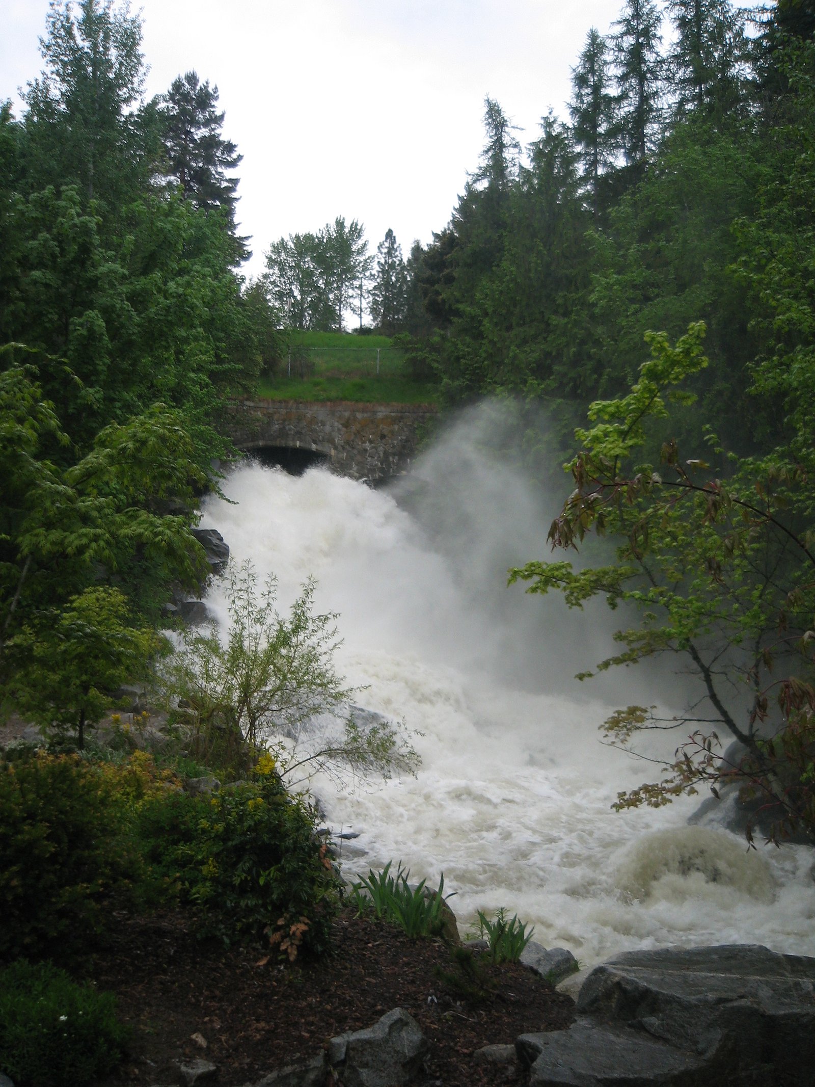
Cottonwood Falls
By Armen Suny · Last verified Jun 2026
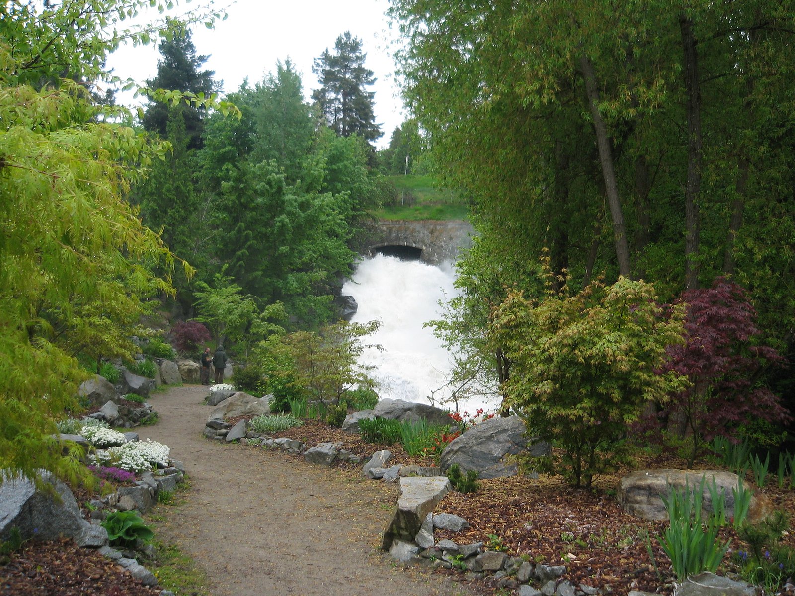
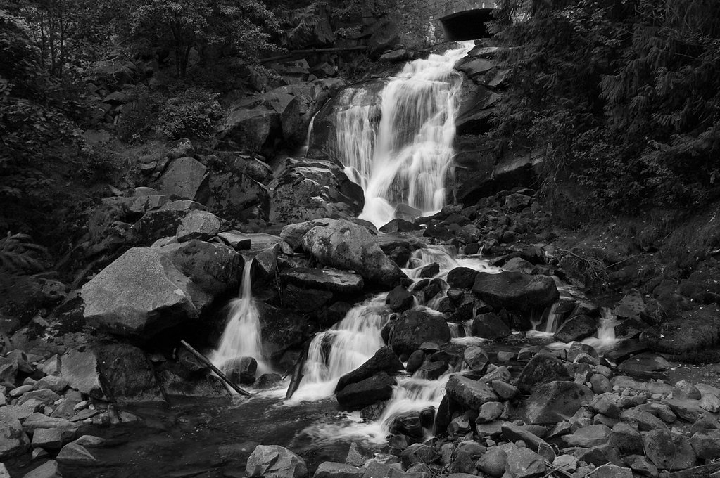
Photo Credits (3)
Difficulty
Easy
Trail Length
0.3 km
Trail Type
Out And Back
Elevation Gain
12 m
About Cottonwood Falls
Cottonwood Falls is a small to medium cascade located near Nelson, British Columbia (coordinates 49.4872, -117.2961). Reported references place it very close to Nelson (approximately 0.7 miles) and within driving distance of Metaline Falls/Metaline across the U.S. border. Flow is typically highest in spring during snowmelt and after heavy rains; summer and fall flows may be reduced. Specific published guidebook data for height and formal trail descriptions appear limited or inconsistent, so some details below are conservative or listed as unknown where confirmation is lacking.
Why This Waterfall Exists
Cottonwood Falls flows over hard intrusive rock laid down about 162-175 million years ago. These resistant rocks form a durable ledge that water cannot easily wear away, creating the falls where softer material downstream has already eroded.
Trail & Hike Details
The Approach
The easy 0.3-km out-and-back trail gains 12 metres of elevation on the way to the falls.
Trail Description
There is limited formal trail documentation for Cottonwood Falls at this exact coordinate. Approaches described by local visitors to similar small waterfalls near Nelson tend to be short but may follow unmarked footpaths over uneven, sometimes steep or brushy terrain. Trails (if present) may be narrow, rocky, and can include short sections of steep descent to view the falls. Signage and maintenance level may be minimal.
What to Expect
Expect a woodland setting with the waterfall on a creek or small river. Water flow will be seasonal, highest in spring and after heavy rain. The immediate area can be wet, muddy, and slippery; fallen trees, brush, and loose rock are common. Views may be limited from a single overlook; getting closer often requires scrambling on wet rocks or down a steep bank. Cell coverage may be spotty in some places around Nelson and in nearby valleys.
Accessibility
The trail is short and relatively flat, but the surface may be uneven. Contact the managing agency for accessibility details.
Frequently Asked Questions
🐶 Are Dogs Allowed at Cottonwood Falls?
❌ Dogs are not allowed
Are There Any Fees or Permits Required?
🆖 No fees required
🏊 Is There Swimming at Cottonwood Falls?
❌ Swimming is not allowed
When to Visit
Late spring for peak flow from snowmelt; early summer for good weather with decent flows; fall for lower crowds and fall colors. Winter visits are possible but may be icy and hazardous, many approaches can be unsafe when icy or covered in snow.
Seasonal Access
The best time to visit is Spring, Summer, and Fall. Winter access may be limited. Check with the managing park or local authority for current conditions.
Safety Information
Hazards may include slippery and unstable rocks, steep banks, fast cold water (especially in spring), falling trees or branches, limited signage, and possible private property boundaries. Cell service may be unreliable in some locations. If flow is high, keep a safe distance. Do not climb on wet rock ledges or undercut banks. Always tell someone your plans and expected return time. Check local conditions and land access rules before visiting.
Current Water Conditions
0.0 m³/s
Current discharge — how much water is flowing
Much lower than usual for this time of year
Based on 64 years of record
0.06 m
Water depth at gauge
7-Day Discharge Trend
What does this mean for your visit?
Flow is well below normal for this time of year, so the waterfall may be a trickle.
About This Gauge
7-Day Flow Outlook
Based on the WSC gauge ANDERSON CREEK NEAR NELSON (3 km away).
Today
Barely Flowing
0.0 m³/s
5/10Tomorrow
Barely Flowing
0.0 m³/s
4/10Tue
Barely Flowing
0.0 m³/s
4/10Wed
Barely Flowing
0.0 m³/s
4/10Thu
Barely Flowing
0.0 m³/s
3/10Fri
Low
0.0 m³/s
4/10Sat
Barely Flowing
0.0 m³/s
4/10Best window: Today — barely flowing flow, mainly sunny (trip score 5/10).
Best time of year: this gauge typically runs highest from early April to early July, peaking in May.
How we calculate this
This is a transparent outlook, not a precise forecast. We take the waterfall's current flow strength (how it ranks against its historical normal for today, from the nearest WSC stream gauge), carry that ranking forward along the gauge's seasonal curve, and nudge it for forecast rain. Confidence is highest for the next day or two and falls further out. Always check official conditions and your own judgment before visiting — high flows can be dangerous.
Know when to go.
Get a free email alert when waterfalls near Nelson hit peak flow. We only send when conditions are worth the trip — no weekly newsletters, no spam.
Weather Forecast
Location & Access
Getting There
The waterfall is located at approximately 49.4872, -117.2961, near the city of Nelson, BC. From downtown Nelson the site is reported to be roughly 0.7 miles away (check local maps for the precise access point). Access is likely via local roads and possibly short gravel or forestry roads; approaches may include informal pullouts or short footpaths rather than an established trailhead. If coming from the U.S. side, Metaline Falls (WA) is roughly 33–35 miles away. Visitors should consult local maps, municipal parks pages, or local hiking resources before visiting.
Get Directions on Google MapsParking
Parking may be limited to roadside pullouts or small informal lots. There may not be an established paved parking lot. Expect limited signage and possibly private driveways nearby, avoid blocking access. If unsure, park in legal designated spots in Nelson and approach on foot or check with local authorities.
Elevation
561 metres above sea level
Coordinates
49.487222° N, -117.296094° W
Visitor Tips & Gear
• Confirm exact access and any local restrictions with Nelson visitor resources or local hiking groups before you go. • Wear sturdy, waterproof footwear, rocks and routes near the falls can be slippery. • Bring a map or GPS with the provided coordinates; trail signage may be minimal. • Respect private property: some approaches to local falls cross private or leased land. • Avoid getting too close to the edge, wet rocks and undercut banks are hazardous. • If visiting in spring, expect higher flows and stronger currents; exercise extra caution.
As an Amazon Associate, we earn from qualifying purchases.
For this easy 0.3 km trail, lightweight trail shoes and a water bottle are usually sufficient. Sun exposure on the trail makes good sun protection a must in summer.

Polarized Sunglasses (Knockaround)
Cuts glare off the water so you actually see the falls — and your photos turn out better too.

Columbia Watertight II Rain Jacket
Packs into its own pocket, seam-sealed, and keeps you dry from spray and surprise rain.

Earth Pak Waterproof Dry Bag
Keeps your phone and gear dry when waterfall mist soaks everything else.

Waterproof Phone Pouch (AiRunTech)
Cheap insurance — take photos right next to the falls without killing your phone.

JOBY GorillaPod Starter Kit
Wraps around railings and rocks for long-exposure waterfall shots — no flat surface needed.

Osprey Daylite Daypack
Light, organized, and just the right size for a day hike — fits water, snacks, and layers.
Where to Stay
Browse vacation cabins and private rentals nearby
Unique outdoor stays — tents, yurts, and treehouses
Rent a campervan or RV for your waterfall road trip
Some links are affiliate links. We may earn a commission at no extra cost to you.
Nearby Campground
Nelson Camp Ground
1.3 km away
Additional Information
Nearby Attractions
Nelson (historic town with shops, galleries, and restaurants), Kootenay Lake shoreline and parks, local day hikes in the Nelson area. Kokanee Glacier and other high-elevation sites are accessible further afield but not immediate to this falls coordinate.
Wildlife
Typical southeastern British Columbia wildlife: deer, black bears, small mammals, various birds and waterfowl. Take standard wildlife precautions (store food securely, give animals space).
Cities near Cottonwood Falls
Other waterfalls named Cottonwood Falls
3 other waterfalls share this name across Canada.
Writing about Cottonwood Falls? Embed this waterfall on your site for free.