Photo Credits (1)
Difficulty
Easy
Trail Length
1.3 km
Trail Type
Out And Back
Elevation Gain
15 m
About Chutes de Shawinigan
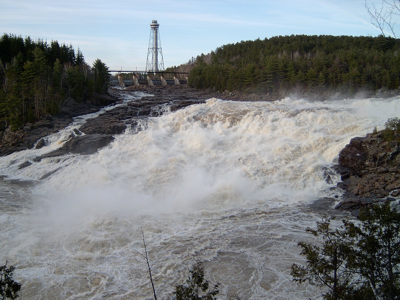
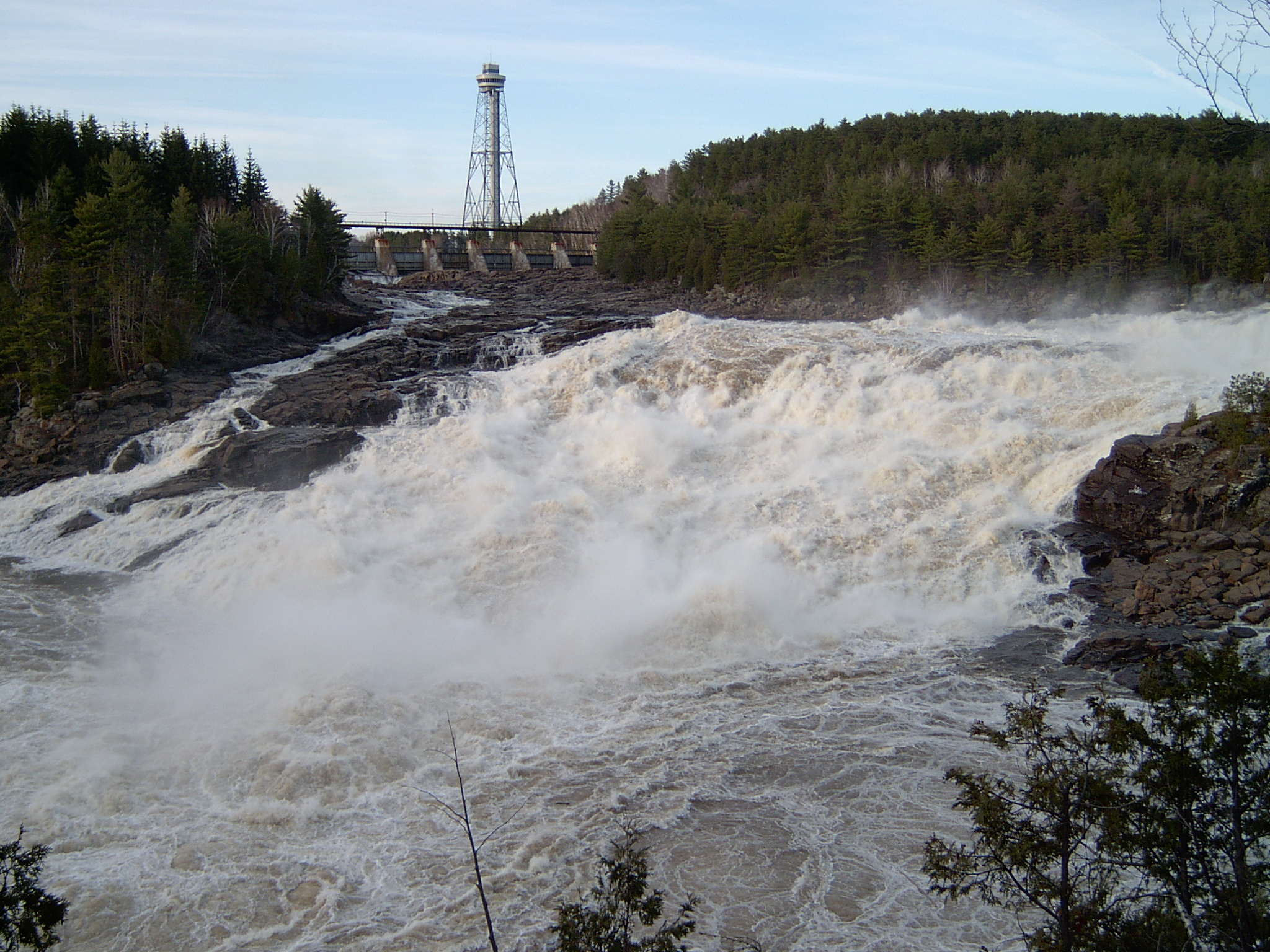
Shawinigan Falls are waterfalls located on the Saint-Maurice River in Shawinigan. With a height of 50 meters, their drops were used for the construction of five hydroelectric power stations.
The Setting
Chutes de Shawinigan sits at 57 metres in the coastal lowlands of Quebec. At 44 metres, it is among the taller waterfalls in Quebec.
Why This Waterfall Exists
Chutes de Shawinigan flows over hard banded metamorphic rock, primarily gneiss, laid down over 1.4-1.6 billion years ago. These resistant rocks form a durable ledge that water cannot easily wear away, creating a 145-foot drop where softer material downstream has already eroded.
Trail & Hike Details
The Approach
The easy 1.3-km out-and-back trail gains 15 metres of elevation on the way to the falls.
Trail Description
A short, mostly paved or well‑formed path connects parking/park areas to lookout platforms above the falls. There are established observation decks and stairs; some sections may include boardwalks or gravel paths. The primary experience is scenic viewing from designated platforms rather than a long backcountry trail.
What to Expect
The falls cascade 44 metres over hard banded metamorphic rock.
Accessibility
The trail is short and relatively flat, but the surface may be uneven. Contact the managing agency for accessibility details.
Frequently Asked Questions
🐶 Are Dogs Allowed at Chutes de Shawinigan?
❌ Dogs are not allowed
Are There Any Fees or Permits Required?
🆖 No fees required
🏊 Is There Swimming at Chutes de Shawinigan?
❌ Swimming is not allowed
When to Visit
Late spring for highest water flow (after snowmelt) and early fall for color and generally stable weather. Summer is good for easy access; winter offers ice formations but increased hazard and possible restricted access.
Seasonal Access
The best time to visit is Spring, Summer, Fall, and Winter. Check with the managing park or local authority for current conditions.
Safety Information
Hazards include slippery rocks, steep edges, fast currents, changing river levels, and winter ice. Stay on marked trails and behind railings. Do not attempt to climb on rocks near the water or enter the river near the falls. Check for seasonal warnings or temporary closures before visiting.
7-Day Flow Outlook
Based on the WSC gauge BATISCAN (RIVIERE) A 3,4 KM EN AVAL DE LA RIVIERE DES ENVIES (28 km away).
Best time of year: this gauge typically runs highest from early April to mid June, peaking in April.
How we calculate this
This is a transparent outlook, not a precise forecast. We take the waterfall's current flow strength (how it ranks against its historical normal for today, from the nearest WSC stream gauge), carry that ranking forward along the gauge's seasonal curve, and nudge it for forecast rain. Confidence is highest for the next day or two and falls further out. Always check official conditions and your own judgment before visiting — high flows can be dangerous.
Know when to go.
Get a free email alert when waterfalls near Shawinigan-Sud hit peak flow. We only send when conditions are worth the trip — no weekly newsletters, no spam.
Weather Forecast
Location & Access
Getting There
Located at approx. 46.5312, -72.7616 on the Saint‑Maurice River near downtown Shawinigan‑Sud. The falls are accessed from local city roads off Autoroute 55/Route 153 (follow signage to Parc de la Cité de l'Énergie / downtown Shawinigan). Distances to nearby towns: Shawinigan‑Sud ~0.6 miles, Trois‑Rivières ~17.8 miles, Drummondville ~43.4 miles.
Get Directions on Google MapsParking
Municipal parking areas and park lots are typically available near viewpoints; paid parking may apply at city/park facilities during special events. Park near official lots and follow signage, street parking is available in adjacent neighborhoods but obey local restrictions.
Elevation
57 metres above sea level
Coordinates
46.531230° N, -72.761591° W
Visitor Tips & Gear
• Use designated viewpoints and stay behind railings, rocks near the river are slippery and currents are strong. • Spring offers the largest flows and dramatic views; fall combines good flow with foliage color. • Wear sturdy, non‑slip shoes; bring layers and rain protection if you plan to linger near mist. • Check local park/municipal websites or phone lines for any temporary closures or parking fees. • If visiting in winter, bring traction devices and be prepared for closed/icy access points.
As an Amazon Associate, we earn from qualifying purchases.
For this easy 1.3 km trail, lightweight trail shoes and a water bottle are usually sufficient. Icy conditions are common in winter — traction cleats are a smart addition.

Columbia Watertight II Rain Jacket
Packs into its own pocket, seam-sealed, and keeps you dry from spray and surprise rain.

Polarized Sunglasses (Knockaround)
Cuts glare off the water so you actually see the falls — and your photos turn out better too.

Earth Pak Waterproof Dry Bag
Keeps your phone and gear dry when waterfall mist soaks everything else.

Waterproof Phone Pouch (AiRunTech)
Cheap insurance — take photos right next to the falls without killing your phone.

Kahtoola MICROspikes
Cult-favorite traction cleats that grip ice and wet rock — essential for winter waterfall hikes.

JOBY GorillaPod Starter Kit
Wraps around railings and rocks for long-exposure waterfall shots — no flat surface needed.
Where to Stay
Browse vacation cabins and private rentals nearby
Unique outdoor stays — tents, yurts, and treehouses
Rent a campervan or RV for your waterfall road trip
Some links are affiliate links. We may earn a commission at no extra cost to you.
Nearby Campground
Camping de l'Île-Melville
0.9 km away
Additional Information
Nearby Attractions
Parc de la Cité de l'Énergie and its interpretive centre, local downtown Shawinigan amenities, riverside parks. La Mauricie National Park and other Mauricie region attractions are within driving distance.
Wildlife
Typical southern Québec riparian and forest species, songbirds, waterfowl, beavers, small mammals, and occasional deer. Observe wildlife from a distance and do not feed animals.
Cities near Chutes de Shawinigan
Nearby Waterfalls
Writing about Chutes de Shawinigan? Embed this waterfall on your site for free.