Difficulty
Drive Up
Trail Length
0.2 km
About Chute à Madeleine
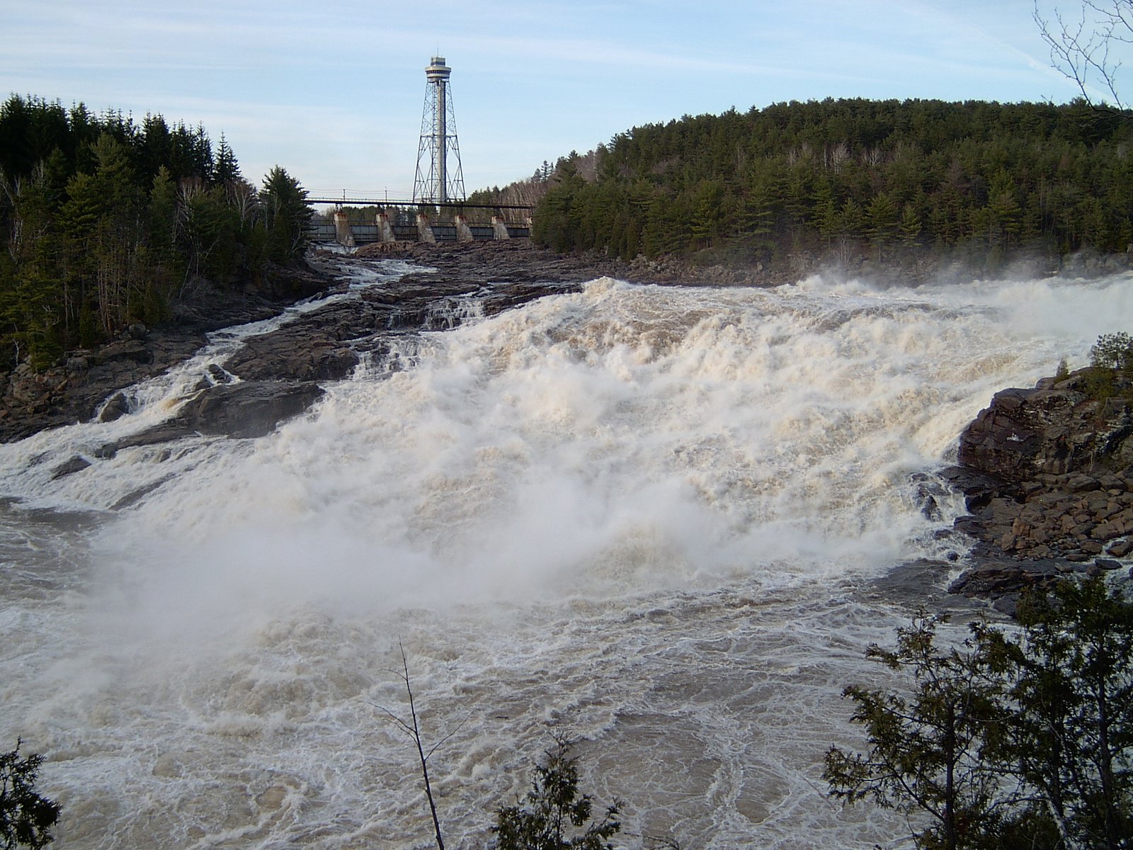
Chute à Madeleine is a local waterfall in the Mauricie region of Quebec near Shawinigan‑Sud (coordinates 46.4622, -72.7699). It is a riverside cascade/vertical drop that is most notable at higher flows in spring. Exact upstream drainage and official provincial park affiliation are not confirmed here, so visitors should treat this as a roadside/regional feature rather than a staffed park attraction.
Why This Waterfall Exists
Chute à Madeleine flows over layered sedimentary rock laid down about 458-470 million years ago. Over time, the stream has worn through these layers at different rates, creating the step that forms the waterfall.
Nearby Falls Worth Visiting
Chutes de Shawinigan (44 m) lies 7.7 kilometres to the north.
Trail & Hike Details
The Approach
No hiking required. Chute à Madeleine is accessible by vehicle with a roadside viewing area.
Trail Description
Reported visitor access appears to be via a short, possibly unmaintained footpath from a nearby roadside parking/pullout. Trails may be uneven, narrow and occasionally steep near the riverbank; there may not be built boardwalks, railings or formal viewpoints. Navigation may rely on local signage or GPS coordinates.
What to Expect
Expect a scenic riverside cascade that is most impressive during spring melt or after heavy rain. Surrounding terrain is typically mixed forest with exposed rocks and wet, slippery surfaces near the falls. There may be limited infrastructure (no visitor center, platforms or formal restrooms). Cell reception may be spotty in places.
Accessibility
This waterfall is viewable from a vehicle-accessible area. No hiking is required.
Frequently Asked Questions
🐶 Are Dogs Allowed at Chute à Madeleine?
❌ Dogs are not allowed
Are There Any Fees or Permits Required?
🆖 No fees required
🏊 Is There Swimming at Chute à Madeleine?
❌ Swimming is not allowed
When to Visit
Spring (high runoff) for strongest flow and dramatic appearance; fall for foliage colors and easier mosquito conditions than summer; summer for generally accessible trails; winter can produce ice formations but access may be hazardous and trails icy.
Seasonal Access
The best time to visit is Spring, Summer, Fall, and Winter. Check with the managing park or local authority for current conditions.
Safety Information
Hazards include slippery rocks, steep banks, cold swift water, and seasonally high flows. Ice in winter can be hazardous; do not walk on frozen water unless confirmed safe. Cell service may be limited. Always tell someone your plans, carry a means of navigation, and call emergency services (911) in Canada for serious incidents. When unsure about conditions, err on the side of caution.
7-Day Flow Outlook
Based on the WSC gauge MASKINONGE (RIVIERE) AU PONT DU C.N. PRES DE SAINTE-URSULE (31 km away).
Best time of year: this gauge typically runs highest from early April to early June, peaking in May.
How we calculate this
This is a transparent outlook, not a precise forecast. We take the waterfall's current flow strength (how it ranks against its historical normal for today, from the nearest WSC stream gauge), carry that ranking forward along the gauge's seasonal curve, and nudge it for forecast rain. Confidence is highest for the next day or two and falls further out. Always check official conditions and your own judgment before visiting — high flows can be dangerous.
Know when to go.
Get a free email alert when waterfalls near Shawinigan-Sud hit peak flow. We only send when conditions are worth the trip — no weekly newsletters, no spam.
Weather Forecast
Location & Access
Getting There
Access is by car from Shawinigan‑Sud (about 4 miles), Trois‑Rivières (~15 miles) or Drummondville (~40 miles). Use GPS coordinates 46.4622, -72.7699. The waterfall is reached via local roads and short forest/field access; signage and formal approach details are not confirmed and GPS/phone mapping is recommended.
Get Directions on Google MapsParking
Parking may be limited to a small roadside pullout or informal lot near the trailhead; there may not be a staffed or paved parking area. Expect seasonal or limited parking and obey any posted signs.
Elevation
36 metres above sea level
Coordinates
46.462220° N, -72.769873° W
Visitor Tips & Gear
Wear sturdy, grippy footwear and exercise caution on wet rocks. Stay back from the edge and avoid attempting to climb directly to the base unless a safe, established route exists. Check local weather and recent visitor reports for water levels and seasonal access. Bring a map or use GPS coordinates; parking may be informal. Respect private property and posted signs.
Where to Stay
Browse vacation cabins and private rentals nearby
Unique outdoor stays — tents, yurts, and treehouses
Rent a campervan or RV for your waterfall road trip
Some links are affiliate links. We may earn a commission at no extra cost to you.
Nearby Campground
Camping lac Blais
2.6 km away
Additional Information
Nearby Attractions
Shawinigan‑Sud and the city of Shawinigan offer viewpoints, regional parks and river access; Trois‑Rivières is the nearest larger city. There may be other small cascades and scenic river stops in the Mauricie region. For established parks in the region, check provincial park listings before travel.
Wildlife
Typical regional wildlife may include white‑tailed deer, beavers, small mammals, waterfowl and a variety of songbirds. Black bears are present in parts of Mauricie; practice standard wildlife precautions.
Cities near Chute à Madeleine
Nearby Waterfalls
Writing about Chute à Madeleine? Embed this waterfall on your site for free.