About Chute à Hélène
Chute à Hélène is a local waterfall feature near Shawinigan-Sud in Quebec. The site sits in a mixed forest / river valley setting typical of the Mauricie region and is most often visited by locals and regional hikers. Specific published data about the waterfall's vertical drop and formal facilities is limited; descriptions below use conservative language where details are not well documented.
Why This Waterfall Exists
Chute à Hélène flows over layered sedimentary rock laid down about 458-470 million years ago. Over time, the stream has worn through these layers at different rates, creating the step that forms the waterfall.
Nearby Falls Worth Visiting
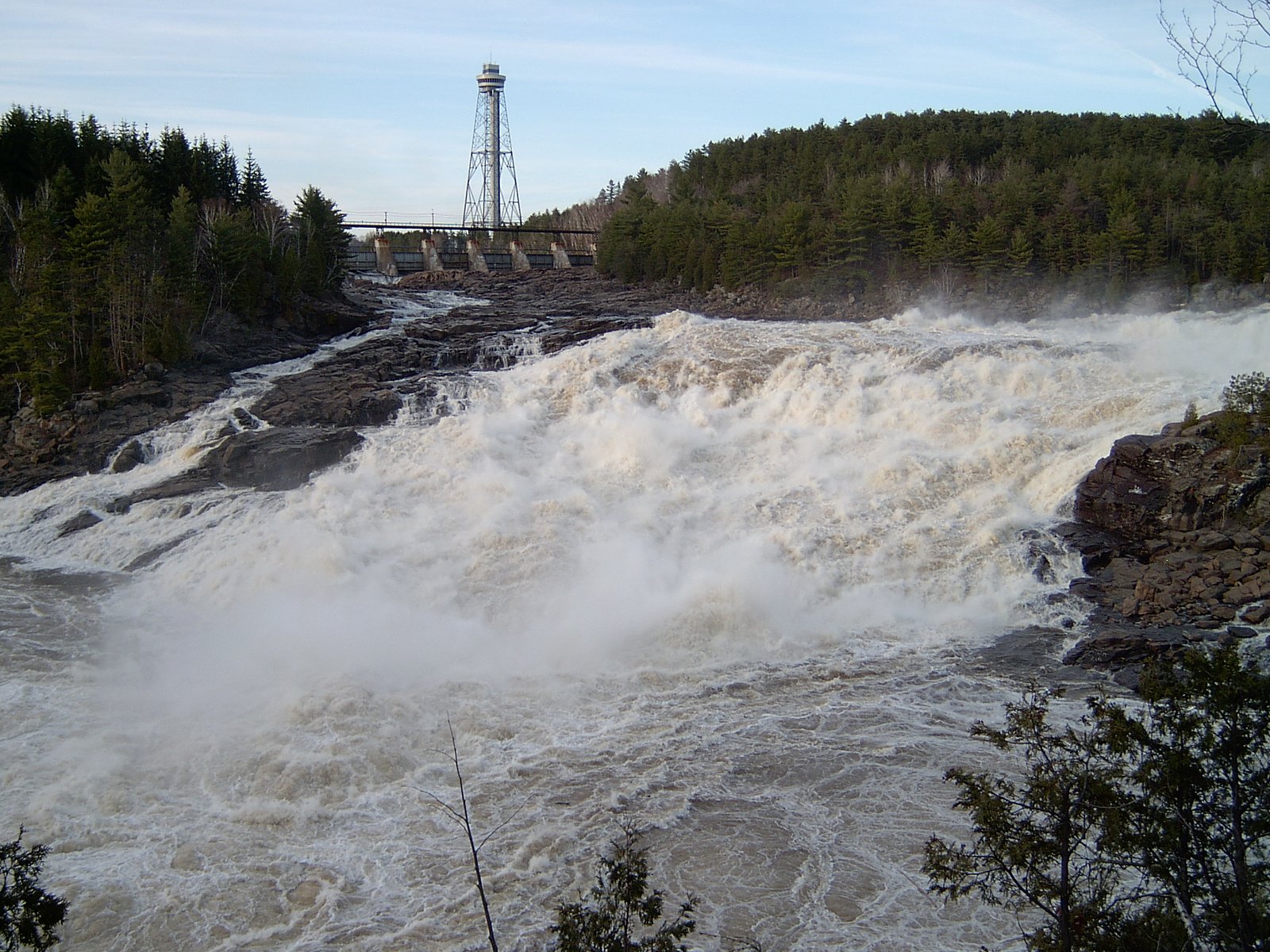
Chutes de Shawinigan (44 m) lies 7.9 kilometres to the north.
Trail & Hike Details
Trail Description
There is no widely published, maintained trail description available for Chute à Hélène. Access appears to be via informal footpaths or short bushwhacks from nearby parking or the roadside. Expect uneven, natural terrain with possible tree roots, rocks, and muddy sections in wet seasons. If a signed or maintained trail exists, it is not well documented in major trail databases.
What to Expect
A relatively small, natural waterfall set in a forested river valley. Expect natural scenery, trees, rock outcrops, and seasonal stream flow that is highest in spring runoff. Facilities (toilets, railings, viewing platforms) are likely absent. Cell service may be variable depending on carrier and exact location.
Accessibility
The site is likely not wheelchair accessible. Trails and viewing areas appear to be natural and uneven; individuals with limited mobility may find access difficult or impossible.
Frequently Asked Questions
🐶 Are Dogs Allowed at Chute à Hélène?
❌ Dogs are not allowed
Are There Any Fees or Permits Required?
🆖 No fees required
🏊 Is There Swimming at Chute à Hélène?
❌ Swimming is not allowed
When to Visit
Late spring (after breakup) and early summer typically provide higher flows and greener scenery; fall offers color. Winter access may be possible but expect snow and ice, only attempt with proper equipment and experience. Visit midweek or early morning for fewer visitors.
Seasonal Access
The best time to visit is Spring, Summer, Fall, and Winter. Check with the managing park or local authority for current conditions.
Safety Information
Hazards may include slippery and unstable rocks near the falls, steep or eroding banks, fast-flowing water (especially during spring runoff), cold water temperatures, and variable trail footing. Use caution near edges, supervise children closely, avoid alcohol near cliffs/water, and consider helmet use if scrambling. In winter, ice and hidden hazards increase risk, only attempt winter visits with appropriate gear and experience. If unsure about conditions, consult local authorities or recent trip reports.
7-Day Flow Outlook
Based on the WSC gauge MASKINONGE (RIVIERE) AU PONT DU C.N. PRES DE SAINTE-URSULE (31 km away).
Best time of year: this gauge typically runs highest from early April to early June, peaking in May.
How we calculate this
This is a transparent outlook, not a precise forecast. We take the waterfall's current flow strength (how it ranks against its historical normal for today, from the nearest WSC stream gauge), carry that ranking forward along the gauge's seasonal curve, and nudge it for forecast rain. Confidence is highest for the next day or two and falls further out. Always check official conditions and your own judgment before visiting — high flows can be dangerous.
Know when to go.
Get a free email alert when waterfalls near Shawinigan-Sud hit peak flow. We only send when conditions are worth the trip — no weekly newsletters, no spam.
Weather Forecast
Location & Access
Getting There
Coordinates: 46.4598, -72.7694. The waterfall is roughly 4.1 miles (6.6 km) from Shawinigan-Sud, about 14.7 miles (23.7 km) from Trois-Rivières, and 40.3 miles (64.8 km) from Drummondville. Use the provided coordinates in a GPS or mapping app to navigate to the closest roadside access. Local roads may be narrow and seasonal; confirm routing before travel.
Get Directions on Google MapsParking
Parking is likely informal and limited (small roadside turnout or nearby pullout). There is no confirmed official parking lot or developed trailhead; visitors should expect minimal facilities and use caution when parking on narrow shoulders.
Elevation
61 metres above sea level
Coordinates
46.459842° N, -72.769417° W
Visitor Tips & Gear
• Use the exact coordinates to locate the site; local signage may be limited. • Wear sturdy footwear; trails are likely rough and can be slippery when wet. • Park legally and safely off the roadway; avoid blocking shoulders. • Bring a map or download offline maps, GPS can drift in valleys and forests. • Leave no trace: pack out garbage and avoid disturbing vegetation and streambanks. • Respect private property, some nearby access points may cross or abut private land.
Where to Stay
Browse vacation cabins and private rentals nearby
Unique outdoor stays — tents, yurts, and treehouses
Rent a campervan or RV for your waterfall road trip
Some links are affiliate links. We may earn a commission at no extra cost to you.
Nearby Campground
Camping lac Blais
2.6 km away
Additional Information
Nearby Attractions
Shawinigan city amenities and viewpoints; the Saint-Maurice River corridor; nearby regional parks and recreational sites in the Mauricie area. Parc national de la Mauricie is in the broader region (confirm exact distance and access).
Wildlife
Typical regional wildlife may include white-tailed deer, beavers, waterfowl, songbirds, and small mammals. Black bears and moose occur in the broader region, practice standard wildlife awareness (store food securely, keep distance).
Cities near Chute à Hélène
Nearby Waterfalls
Writing about Chute à Hélène? Embed this waterfall on your site for free.