Difficulty
Moderate
Trail Length
8.4 km
Trail Type
Out And Back
Elevation Gain
250 m
About Chute à Clovis
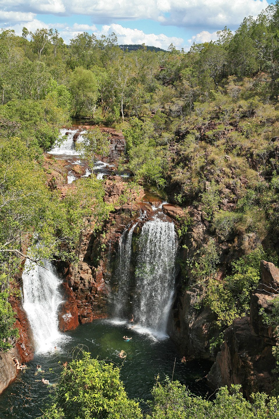
Chute à Clovis is a small forested waterfall located near Cap-Chat, Quebec (coordinates: 48.8435, -66.6948). It appears as a scenic cascade on a local stream surrounded by mixed boreal and coastal forest. Flow can be highly seasonal, higher after spring snowmelt and following heavy rain, lower in late summer. Facilities and formal infrastructure at the site are minimal or absent; access is typically via unpaved/forestry roads and short informal trails. Exact measurements and many facility details are not well-documented in major trail databases, so some specifics below are conservative or noted as uncertain.
The Setting
Chute à Clovis sits at 508 metres within Chic-Chocs Territorial reserve for protected area purposes, in the hills of Quebec.
Why This Waterfall Exists
Chute à Clovis flows over volcanic rock laid down about 485 million to 1.0 billion years ago. These resistant rocks form a durable ledge that water cannot easily wear away, creating the falls where softer material downstream has already eroded.
Trail & Hike Details
The Approach
The moderate 8.4-km out-and-back trail gains 250 metres of elevation on the way to the falls.
Trail Description
Access typically involves driving a secondary or forestry road followed by an informal footpath through mixed forest. Trails near the stream may be narrow, uneven, and not maintained. Approaches to the waterfall can include short steep or slippery sections near the banks. Signage and official trail markers are likely limited or absent, and creek crossings may be present depending on route and season.
What to Expect
A small to medium cascade set in a forested setting. Expect natural, undeveloped surroundings: no restrooms, no maintained viewpoints, and minimal safety features (no guardrails). Water flow varies seasonally; spring and early summer generally offer the most dramatic flow. Mosquitoes and black flies can be numerous in late spring/early summer. Cell coverage may be intermittent.
Accessibility
The trail is not wheelchair accessible. Uneven terrain and elevation changes require steady footing.
Frequently Asked Questions
🐶 Are Dogs Allowed at Chute à Clovis?
❌ Dogs are not allowed
Are There Any Fees or Permits Required?
🆖 No fees required
🏊 Is There Swimming at Chute à Clovis?
❌ Swimming is not allowed
When to Visit
Spring (late snowmelt through early summer) for highest flows and robust water volume; fall for foliage and fewer insects. Summer is fine for access but flow may be lower. Winter can offer frozen/icy scenery but is hazardous (ice, deep snow, and limited access) and requires winter hiking/snowshoe experience and caution.
Seasonal Access
The best time to visit is Spring, Summer, Fall, and Winter. Check with the managing park or local authority for current conditions.
Safety Information
Hazards include slippery rocks and roots, steep banks near the water, cold and fast-moving water, unstable or eroding edges, limited or no safety rails, variable flow depending on season, limited cell reception, and possible private property/forestry operations in the area. In winter expect ice, snow, and avalanche/slide risk on steep terrain in some areas. Always assess conditions, wear appropriate footwear, and avoid getting too close to water edges. If uncertain about access or landownership, check with local municipal authorities or park/forest service.
7-Day Flow Outlook
Based on the WSC gauge SAINTE-ANNE (RIVIERE) A 9,7 KM EN AMONT DU PONT-ROUTE 132 (28 km away).
Best time of year: this gauge typically runs highest from mid April to late June, peaking in May.
How we calculate this
This is a transparent outlook, not a precise forecast. We take the waterfall's current flow strength (how it ranks against its historical normal for today, from the nearest WSC stream gauge), carry that ranking forward along the gauge's seasonal curve, and nudge it for forecast rain. Confidence is highest for the next day or two and falls further out. Always check official conditions and your own judgment before visiting — high flows can be dangerous.
Know when to go.
Get a free email alert when waterfalls near Cap-Chat hit peak flow. We only send when conditions are worth the trip — no weekly newsletters, no spam.
Weather Forecast
Location & Access
Getting There
Approximately 12.2 miles (by road) from the town of Cap-Chat. Generally reached by driving on Route 132 and turning onto local/forestry roads that lead inland; final approach is likely on unpaved roads. Use a detailed map or GPS with the provided coordinates. Expect limited signage; verify land ownership (crown/private) before crossing private property.
Get Directions on Google MapsParking
Likely limited to a small roadside pullout or informal parking at the trailhead. No maintained parking lot or services are known. Parking conditions may be rough; a vehicle with reasonable ground clearance is advisable if using forestry roads.
Elevation
508 metres above sea level
Coordinates
48.843459° N, -66.694819° W
Land Management
Managed by Ministère de l'Environnement, de la Lutte contre les changements climatiques, de la Faune et des Parcs, Direction des aires protégées
Visitor Tips & Gear
• Wear sturdy, waterproof hiking shoes with good traction, rocks and roots are slippery. • Bring insect repellent for spring/summer. • Treat water as cold and potentially fast-moving, avoid getting too close to the edges. • Carry a map/GPS and let someone know your route; cell service may be limited. • Park only in safe, legal locations and avoid blocking access roads. • Leave no trace: pack out all trash and avoid disturbing vegetation or streambanks. • Check local land-ownership and access rules before crossing private property.
As an Amazon Associate, we earn from qualifying purchases.
With 8.4 km and 250 m of elevation gain, sturdy boots and trekking poles will help on this moderate trail. Icy conditions are common in winter — traction cleats are a smart addition.

Columbia Watertight II Rain Jacket
Packs into its own pocket, seam-sealed, and keeps you dry from spray and surprise rain.

Earth Pak Waterproof Dry Bag
Keeps your phone and gear dry when waterfall mist soaks everything else.

Waterproof Phone Pouch (AiRunTech)
Cheap insurance — take photos right next to the falls without killing your phone.

Timberland Euro Sprint Mid Waterproof
Trusted waterproof boot with premium leather and grippy rubber sole — reliable on rocky, wet trails.

TrailBuddy Trekking Poles
Lightweight aluminum, cork grips, and flip-locks that actually hold — a best-seller for good reason.

Kahtoola MICROspikes
Cult-favorite traction cleats that grip ice and wet rock — essential for winter waterfall hikes.
Where to Stay
Browse vacation cabins and private rentals nearby
Unique outdoor stays — tents, yurts, and treehouses
Rent a campervan or RV for your waterfall road trip
Some links are affiliate links. We may earn a commission at no extra cost to you.
Nearby Campground
Camping du Ruisseau-Bascon
1.3 km away
Additional Information
Nearby Attractions
Town of Cap-Chat (coastal scenery and services), scenic coastal drives along Route 132, other local rivers and small falls in the Gaspésie region. The broader Gaspésie area offers hiking and wildlife viewing opportunities.
Wildlife
Typical regional wildlife may include moose, black bear, white-tailed deer, foxes, small mammals, and a variety of birds. Insects such as black flies and mosquitoes can be abundant in warmer months. Always store food securely and follow wildlife-safety best practices.
Cities near Chute à Clovis
Nearby Waterfalls
Writing about Chute à Clovis? Embed this waterfall on your site for free.