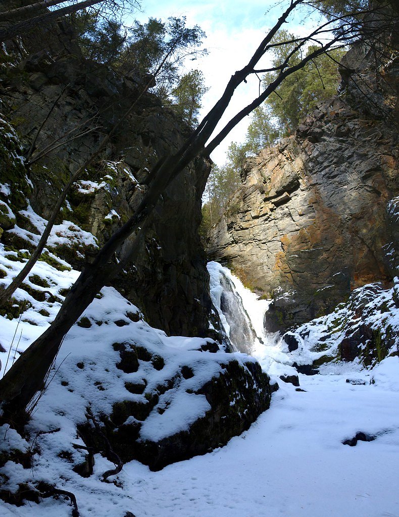
Cayuse Creek Falls
By Armen Suny · Last verified Jun 2026
Difficulty
Drive Up
Trail Length
0.2 km
Trail Type
Out And Back
About Cayuse Creek Falls
Cayuse Creek Falls is a forested, likely seasonal cascade on Cayuse Creek in southeastern British Columbia, located near the Canada–US border (coordinates 49.4064, -117.9931). The falls sit in a remote, wooded area and are most visible after spring snowmelt or periods of heavy rain. Public information about the site is limited; descriptions below are conservative and include typical conditions for small forest waterfalls in this region.
Why This Waterfall Exists
Cayuse Creek Falls flows over hard crystalline rock, primarily granite, laid down about 162-175 million years ago. These resistant rocks form a durable ledge that water cannot easily wear away, creating the falls where softer material downstream has already eroded.
Trail & Hike Details
The Approach
No hiking required. Cayuse Creek Falls is accessible by vehicle with a roadside viewing area.
Trail Description
From the nearest driveable access point (a forestry road pullout or small turnout), a short, unmaintained path typically leads downhill to the creek and the base/viewpoints for the falls. Trails in this area are often narrow, rooty, and may have loose rock or mud. There may be no constructed viewpoints, railings, or stairs; reaching the best vantage points can require scrambling over uneven ground and brush. Expect minimal trail maintenance.
What to Expect
A relatively small forest waterfall or cascade that can be more impressive in spring or after heavy rains. The creek and falls are surrounded by mixed coniferous forest and typical understory vegetation. Water flow may be reduced in late summer and during dry periods. There may be a shallow pool or rocky runout below the falls, but depth and safety are variable. Cell service is likely spotty or absent. Seasonal insects (mosquitoes, black flies) can be numerous in spring and early summer.
Accessibility
This waterfall is viewable from a vehicle-accessible area. No hiking is required.
Frequently Asked Questions
🐶 Are Dogs Allowed at Cayuse Creek Falls?
❌ Dogs are not allowed
Are There Any Fees or Permits Required?
🆖 No fees required
🏊 Is There Swimming at Cayuse Creek Falls?
❌ Swimming is not allowed
When to Visit
Late spring (snowmelt) for highest flows and dramatic appearance; early summer for good access with moderate flow; fall for lower crowds and fall color. Winter access may be limited by snow, ice, and closed forest roads and is not generally recommended unless you are experienced with winter backcountry travel.
Seasonal Access
The best time to visit is Spring, Summer, and Fall. Winter access may be limited. Check with the managing park or local authority for current conditions.
Safety Information
• Slippery rocks, steep banks, and unstable edges are common near the falls, keep a safe distance from the lip and from wet rocks. • Flow can increase rapidly after rain; avoid low spots and river crossings during storms. • Forestry roads may be gated, seasonally closed, or used by industrial traffic, exercise caution and obey posted signs. • Cell service may be unreliable; tell someone your plans and expected return time. • Hypothermia is a risk even in summer if you get wet; dress in layers and carry dry clothing. • If unfamiliar with backcountry travel, consider going with someone who knows the area or hiring a local guide.
Current Water Conditions
0.4 m³/s
Current discharge — how much water is flowing
About average for this time of year
Based on 67 years of record
0.17 m
Water depth at gauge
7-Day Discharge Trend
What does this mean for your visit?
Flow is about average for this time of year.
About This Gauge
7-Day Flow Outlook
Based on the WSC gauge DEER CREEK AT DEER PARK (6 km away).
Today
Low
0.4 m³/s
6/10Tomorrow
Low
0.4 m³/s
5/10Tue
Low
0.4 m³/s
5/10Wed
Low
0.4 m³/s
5/10Thu
Moderate
0.4 m³/s
5/10Fri
Moderate
0.4 m³/s
5/10Sat
Moderate
0.3 m³/s
8/10Best window: Sat — moderate flow, mainly sunny (trip score 8/10).
Best time of year: this gauge typically runs highest from mid April to mid July, peaking in June.
How we calculate this
This is a transparent outlook, not a precise forecast. We take the waterfall's current flow strength (how it ranks against its historical normal for today, from the nearest WSC stream gauge), carry that ranking forward along the gauge's seasonal curve, and nudge it for forecast rain. Confidence is highest for the next day or two and falls further out. Always check official conditions and your own judgment before visiting — high flows can be dangerous.
Know when to go.
Get a free email alert when waterfalls near Nelson hit peak flow. We only send when conditions are worth the trip — no weekly newsletters, no spam.
Weather Forecast
Location & Access
Getting There
The falls are in a remote area of southeastern British Columbia near the towns referenced (Northport ~33.0 miles, Nelson ~33.8 miles, Orient ~35.5 miles). Use the provided coordinates (49.4064, -117.9931) for GPS navigation. Access typically requires driving on secondary/forestry roads off the nearest paved highways; some roads may be unpaved, rough, and seasonally closed. A high-clearance vehicle may be required depending on conditions. Expect limited or no signage; the last portion is often a short unmaintained footpath from the nearest road or pullout.
Get Directions on Google MapsParking
There is likely no formal parking lot. Parking is typically roadside at a pullout along a forestry road. Space is limited and conditions may be muddy; park well off the driving surface and avoid blocking gates or drainage.
Elevation
571 metres above sea level
Coordinates
49.406400° N, -117.993066° W
Visitor Tips & Gear
• Use the provided GPS coordinates rather than relying on signage. • Travel a high-clearance vehicle if you plan to use forestry roads; check local road conditions and closures beforehand. • Wear sturdy, waterproof footwear with good traction, rocks and roots near the creek are slippery. • Expect limited or no facilities; bring water, snacks, and a basic first-aid kit. • Respect private property and forestry operations, do not block gates or drive past closed signs. • Leave no trace: pack out all trash and minimize impact on vegetation and stream banks. • Check recent trip reports or local resources for up-to-date access information before you go.
Where to Stay
Browse vacation cabins and private rentals nearby
Unique outdoor stays — tents, yurts, and treehouses
Rent a campervan or RV for your waterfall road trip
Some links are affiliate links. We may earn a commission at no extra cost to you.
Nearby Campground
Bighorn Campground
8.9 km away
Additional Information
Nearby Attractions
Nearby towns and areas (for services and other recreation) include Nelson (regional services and attractions), local provincial forest recreation areas, and river systems in the Kootenay/Columbia basin. Exact nearby trailheads and named attractions should be confirmed with local tourism or parks resources.
Wildlife
Typical regional wildlife may include deer, elk, black bear, cougar, small mammals, and a variety of birds. Take standard precautions for wildlife: store food securely, keep dogs under control, and be bear-aware in spring–fall.
Cities near Cayuse Creek Falls
Nearby Waterfalls
Writing about Cayuse Creek Falls? Embed this waterfall on your site for free.