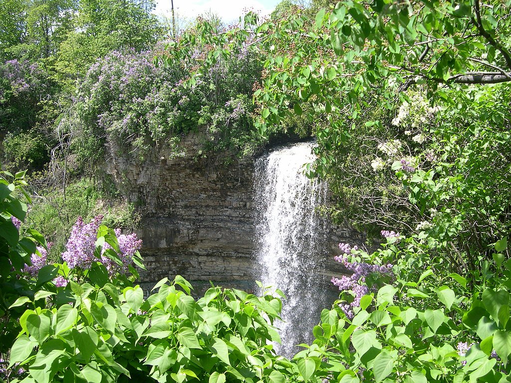
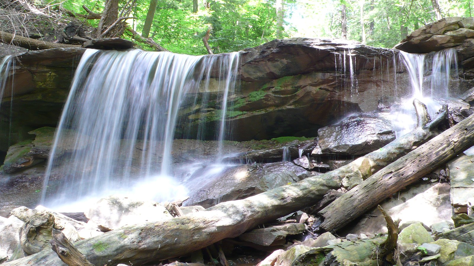
Borer's Falls
Ontario • 15 m
By Armen Suny · Last verified Jun 2026
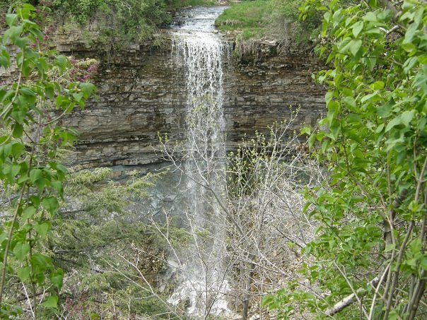
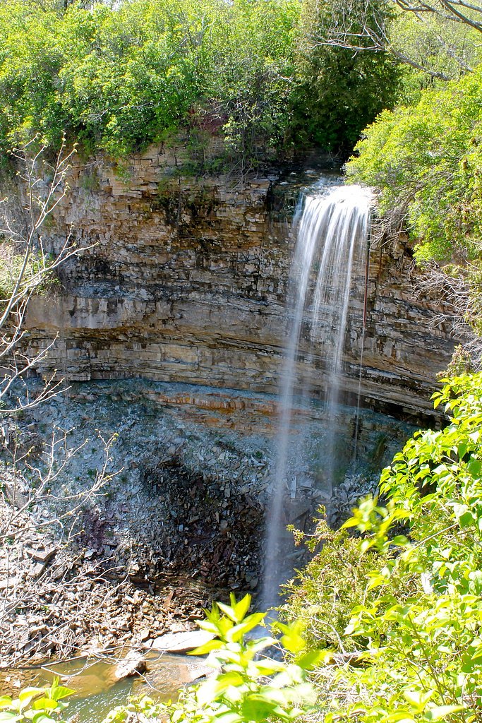
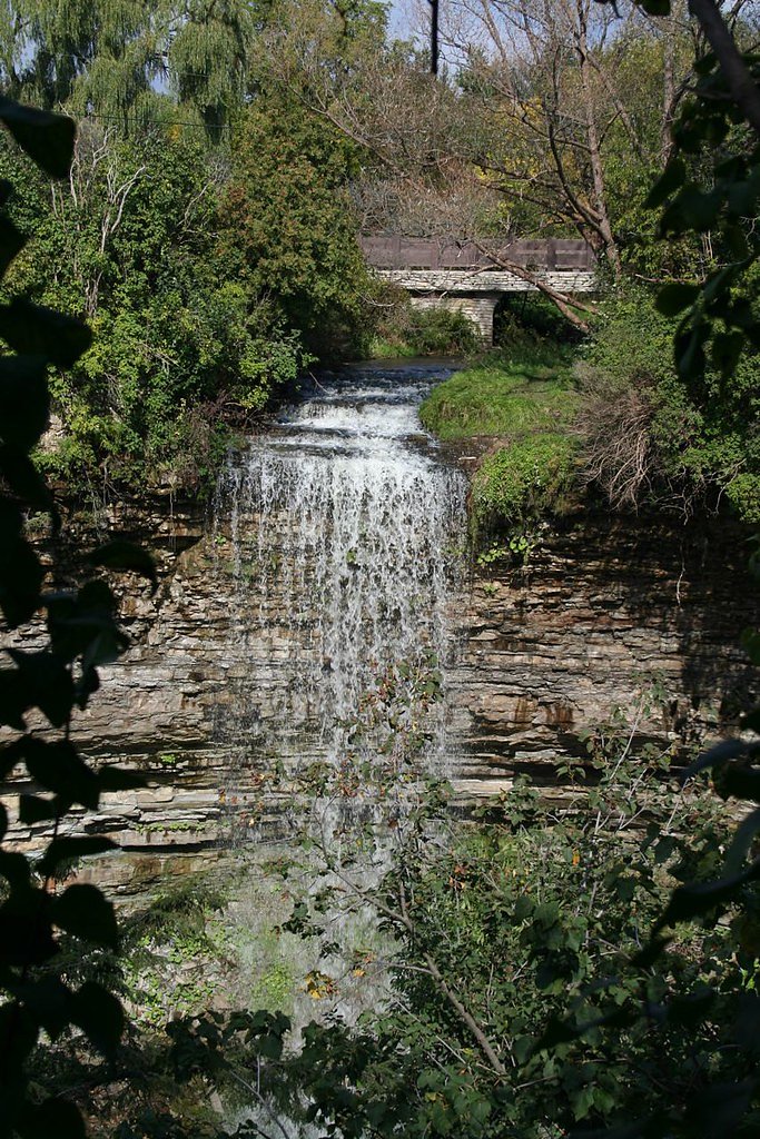
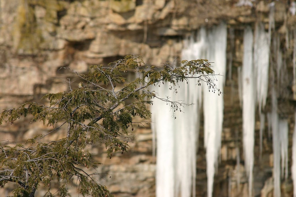

Photo Credits (5)
Difficulty
Moderate
Trail Length
4.3 km
Trail Type
Out And Back
Elevation Gain
35 m
About Borer's Falls
Borer's Falls is a 15-metre-high (49 ft) ribbon-style waterfall found along the trails of Royal Botanical Gardens Rock Chapel trail system in Dundas, Hamilton, Ontario, Canada. A road side walk along the gorge from the parking lot is required to reach it. Its source is Borer's Creek. A very picturesque waterfall featured on many Hamilton waterfall postcards over the years. Named after the Borer family who ran a sawmill for over a century. This mill was the lifeblood of the village of Rock Chapel. Also known as Rock Chapel Falls. The area is a hiker's haven and also an ice-climbing destination in the winter when the weather is cold enough to freeze the Falls.
The Setting
Borer's Falls sits at 213 metres in the foothills of Ontario. The falls drop 15 metres.
Height: 49 feet
Nearby Falls Worth Visiting
Tew's Falls (41 m) lies 3.7 kilometres to the west. Also nearby: Lower Princess Falls (39 m, 5.3 km) and Scenic Falls (20 m, 5.5 km).
Trail & Hike Details
The Approach
The moderate 4.3-km out-and-back trail gains 35 metres of elevation on the way to the falls.
Trail Description
A short out-and-back trail leads from the parking area to one or more viewpoints along the escarpment rim and down toward the gorge. Trails are natural surface, can include roots, rocks and some short steep sections, and may have informal goat paths near viewpoints. There are distinct upper-rim viewpoints; reaching the base or river channel may require scrambling and is not recommended without experience. Trails can be muddy in wet seasons and icy in winter.
What to Expect
The falls drop 15 metres.
Accessibility
The trail is not wheelchair accessible. Uneven terrain and elevation changes require steady footing.
Frequently Asked Questions
🐶 Are Dogs Allowed at Borer's Falls?
❌ Dogs are not allowed
Are There Any Fees or Permits Required?
🆖 No fees required
🏊 Is There Swimming at Borer's Falls?
❌ Swimming is not allowed
When to Visit
Spring for peak flow; fall for foliage and photography; winter can offer dramatic icy formations but presents higher hazards and slippery conditions that require caution and traction devices.
Seasonal Access
The best time to visit is Spring, Summer, Fall, and Winter. Check with the managing park or local authority for current conditions.
Safety Information
Hazards include steep cliffs, loose or slippery rock, sudden changes in water flow, and icy conditions in winter. Stay on marked trails, keep a safe distance from edges, supervise children closely, and avoid cliff edges. Consider traction devices in winter and check local conditions before visiting. Cell service can be spotty, tell someone your plans and expected return time.
Current Water Conditions
0.4 m³/s
Current discharge — how much water is flowing
About average for this time of year
Based on 42 years of record
6.02 m
Water depth at gauge
7-Day Discharge Trend
What does this mean for your visit?
Flow is about average for this time of year.
About This Gauge
7-Day Flow Outlook
Based on the WSC gauge SPENCER CREEK AT DUNDAS (4 km away).
Today
Moderate
0.5 m³/s
9/10Tomorrow
Moderate
0.6 m³/s
8/10Tue
Moderate
0.5 m³/s
6/10Wed
Moderate
0.5 m³/s
8/10Thu
Moderate
0.4 m³/s
8/10Fri
Moderate
0.5 m³/s
6/10Sat
Moderate
0.4 m³/s
6/10Best window: Today — moderate flow, mainly sunny (trip score 9/10).
Best time of year: this gauge typically runs highest from mid February to early May, peaking in April.
How we calculate this
This is a transparent outlook, not a precise forecast. We take the waterfall's current flow strength (how it ranks against its historical normal for today, from the nearest WSC stream gauge), carry that ranking forward along the gauge's seasonal curve, and nudge it for forecast rain. Confidence is highest for the next day or two and falls further out. Always check official conditions and your own judgment before visiting — high flows can be dangerous.
Know when to go.
Get a free email alert when waterfalls near Hamilton hit peak flow. We only send when conditions are worth the trip — no weekly newsletters, no spam.
Weather Forecast
Location & Access
Getting There
Located on the Niagara Escarpment near Hamilton/Burlington (coordinates 43.2938, -79.9368). Access is from a small parking area and local access roads off the escarpment; expect a short walk from parking to the main viewpoints. Use a reliable map or GPS to reach the parking area and follow posted signs and trails to viewpoints. Check local conservation authority pages or recent visitor reports for up-to-date access notes.
Get Directions on Google MapsParking
Small parking area near the trailhead; spaces may be limited and can fill on weekends or peak foliage/flow days. Street parking or nearby lots may be restricted, follow signage. Parking area may be unpaved.
Elevation
213 metres above sea level
Coordinates
43.293837° N, -79.936789° W
Visitor Tips & Gear
1) Wear sturdy, traction-capable footwear, rocks and trails can be slippery. 2) Stay on designated trails and behind guard rails where present; avoid getting too close to precipices. 3) Parking is limited, arrive early on weekends. 4) Check recent trip reports or the local conservation authority for trail and parking conditions. 5) Bring insect repellent in warm months and traction devices (microspikes) in winter.
As an Amazon Associate, we earn from qualifying purchases.
With 4.3 km and 35 m of elevation gain, sturdy boots and trekking poles will help on this moderate trail. Icy conditions are common in winter — traction cleats are a smart addition.

Columbia Watertight II Rain Jacket
Packs into its own pocket, seam-sealed, and keeps you dry from spray and surprise rain.

Polarized Sunglasses (Knockaround)
Cuts glare off the water so you actually see the falls — and your photos turn out better too.

Earth Pak Waterproof Dry Bag
Keeps your phone and gear dry when waterfall mist soaks everything else.

Waterproof Phone Pouch (AiRunTech)
Cheap insurance — take photos right next to the falls without killing your phone.

Timberland Euro Sprint Mid Waterproof
Trusted waterproof boot with premium leather and grippy rubber sole — reliable on rocky, wet trails.

TrailBuddy Trekking Poles
Lightweight aluminum, cork grips, and flip-locks that actually hold — a best-seller for good reason.
Where to Stay
Browse vacation cabins and private rentals nearby
Unique outdoor stays — tents, yurts, and treehouses
Rent a campervan or RV for your waterfall road trip
Some links are affiliate links. We may earn a commission at no extra cost to you.
Nearby Campground
Lost Forest Park & Camping Resort
9.8 km away
Additional Information
Nearby Attractions
The Hamilton/Burlington area hosts many Niagara Escarpment waterfalls and conservation areas (e.g., Spencer Gorge/Webster’s Falls/Tews Falls, Dundas Valley), making the region popular for waterfall touring.
Wildlife
Typical escarpment woodland wildlife: songbirds, raptors, small mammals (squirrels, raccoons), and white-tailed deer. Ticks and mosquitoes may be present seasonally.
Cities near Borer's Falls
Nearby Waterfalls
Writing about Borer's Falls? Embed this waterfall on your site for free.