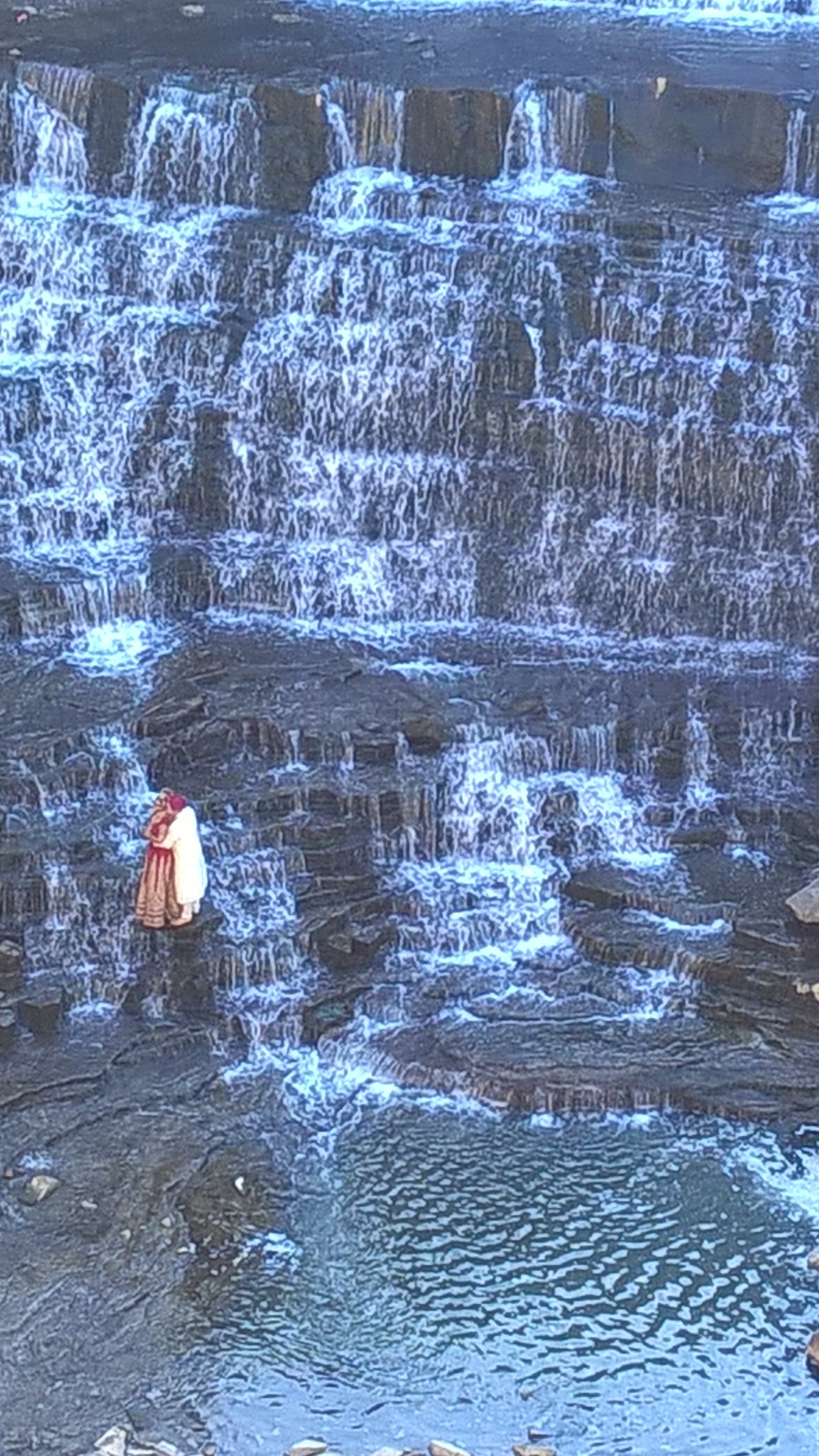
Woonsocket Falls
By Armen Suny · Last verified May 2026
Difficulty
Moderate
Trail Length
2.4 miles
Trail Type
Out And Back
Elevation Gain
350 ft
About Woonsocket Falls
Woonsocket Falls sits in the heart of Woonsocket, Rhode Island, where the Blackstone River drops through the city and anchors a compact, historic industrial landscape. The falls have long been a focal point of the downtown — framed by bridges, riverwalks and urban development — and make for an accessible, scenic stop for visitors exploring the city. While the site lacks a wilderness trail, local walkers and history-minded visitors frequently combine street-level viewpoints and short riverfront paths to take in multiple angles of the falls. A commonly used route in the area is a roughly 2.4-mile out-and-back loop that gains about 350 feet and is typically rated moderate; it’s a pleasant urban hike that ties together overlooks, bridges and nearby historic features.
The Setting
Woonsocket Falls sits at 144 feet along the Blackstone River, in the coastal lowlands of Rhode Island.
Trail & Hike Details
The Approach
The moderate 2.4-mile out and back trail gains 350 feet of elevation on the way to the falls.
Trail Description
There is no USFS-managed trail or designated backcountry route to Woonsocket Falls — the falls are accessed from city streets, bridges and short riverfront paths. However, a popular local outing is a 2.4-mile out-and-back route with approximately 350 feet of elevation gain, usually rated moderate in difficulty. No USFS trail name or trail number applies to this site, and no USFS surface/grade/class data are available for the urban viewing route.
What to Expect
Expect an urban waterfall surrounded by historic mill buildings and city infrastructure. The falls are part of the Blackstone River and may vary in flow depending on the season and rainfall.
Accessibility
The trail is not wheelchair accessible. Uneven terrain and elevation changes require steady footing.
Frequently Asked Questions
🐶 Are Dogs Allowed at Woonsocket Falls?
❌ Dogs are not allowed
Are There Any Fees or Permits Required?
🆖 No fees required
🏊 Is There Swimming at Woonsocket Falls?
❌ Swimming is not allowed
When to Visit
Spring and after periods of heavy rain are ideal for viewing the falls at their fullest.
Seasonal Access
The best time to visit is Spring, Summer, Fall, and Winter.
Safety Information
Be cautious of traffic when viewing the falls from bridges or streets. Avoid getting too close to the river's edge, as the water can be fast-moving and dangerous.
Current Water Conditions
145 ft³/s
Current discharge — how much water is flowing
Lower than usual for this time of year
Based on 97 years of record
0.89 ft
Water depth at gauge
7-Day Discharge Trend
What does this mean for your visit?
Flow is lower than usual for this time of year.
About This Gauge
7-Day Flow Outlook
Based on the USGS gauge BLACKSTONE RIVER AT WOONSOCKET, RI (2 km away).
Today
Barely Flowing
147 cfs
5/10Tomorrow
Low
168 cfs
3/10Sun
Low
157 cfs
6/10Mon
Barely Flowing
147 cfs
5/10Tue
Low
168 cfs
3/10Wed
Low
169 cfs
4/10Thu
Low
165 cfs
4/10Best window: Sun — low flow, sunny (trip score 6/10).
How we calculate this
This is a transparent outlook, not a precise forecast. We take the waterfall's current flow strength (how it ranks against its historical normal for today, from the nearest USGS stream gauge), carry that ranking forward along the gauge's seasonal curve, and nudge it for forecast rain. Confidence is highest for the next day or two and falls further out. Always check official conditions and your own judgment before visiting — high flows can be dangerous.
Know when to go.
Get a free email alert when waterfalls near Woonsocket hit peak flow. We only send when conditions are worth the trip — no weekly newsletters, no spam.
Weather Forecast
Location & Access
Getting There
Woonsocket Falls is located in downtown Woonsocket, Rhode Island, and can be accessed via local roads. The falls are visible from several vantage points near the Main Street Bridge and Market Square.
Get Directions on Google MapsParking
There is limited street parking available near Market Square and nearby public lots. Visitors should check for parking signs and restrictions.
Hours
Elevation
144 feet above sea level
Coordinates
41.999167° N, -71.517778° W
Visitor Tips & Gear
Visit during the spring or after heavy rains for the most impressive water flow. Be cautious of traffic when viewing the falls from bridges or streets.
As an Amazon Associate, we earn from qualifying purchases.
With 2.4 miles and 350 ft of elevation gain, sturdy boots and trekking poles will help on this moderate trail. Icy conditions are common in winter — traction cleats are a smart addition.

Columbia Watertight II Rain Jacket
Packs into its own pocket, seam-sealed, and keeps you dry from spray and surprise rain.

Earth Pak Waterproof Dry Bag
Keeps your phone and gear dry when waterfall mist soaks everything else.

Waterproof Phone Pouch (AiRunTech)
Cheap insurance — take photos right next to the falls without killing your phone.

Timberland Euro Sprint Mid Waterproof
Trusted waterproof boot with premium leather and grippy rubber sole — reliable on rocky, wet trails.

TrailBuddy Trekking Poles
Lightweight aluminum, cork grips, and flip-locks that actually hold — a best-seller for good reason.

Kahtoola MICROspikes
Cult-favorite traction cleats that grip ice and wet rock — essential for winter waterfall hikes.
Where to Stay

Holiday Inn Express Hotel & Suites Providence-Woonsocket by IHG

Courtyard by Marriott Providence Lincoln

Hampton Inn & Suites Providence / Smithfield

Hampton Inn Franklin
Browse vacation cabins and private rentals nearby
Unique outdoor stays — tents, yurts, and treehouses
Rent a campervan or RV for your waterfall road trip
Some links are affiliate links. We may earn a commission at no extra cost to you.
Nearby Campground
WEST HILL PARK
8.9 miles away · 3 sites
Overview On a quiet back road and across an old fieldstone bridge lies West Hill Park, where the West River widens to form a large, natural pool. The park and its many services and activities, including a swimming beach, accessible playground, nature trails and calm, clean water, attract visitors of all ages. Three group shelters, one near the dam, are ideal facilities for hosting graduation parties, family reunions and church or other organization events. The recreation area can be reserved duri
Book on Recreation.govAdditional Information
Nearby Attractions
Nearby attractions include the Museum of Work and Culture, Blackstone River Bikeway, and historic mill buildings in downtown Woonsocket.
Wildlife
Urban wildlife such as birds and small mammals may be observed in the area.
Cities near Woonsocket Falls
Nearby Waterfalls
Writing about Woonsocket Falls? Embed this waterfall on your site for free.