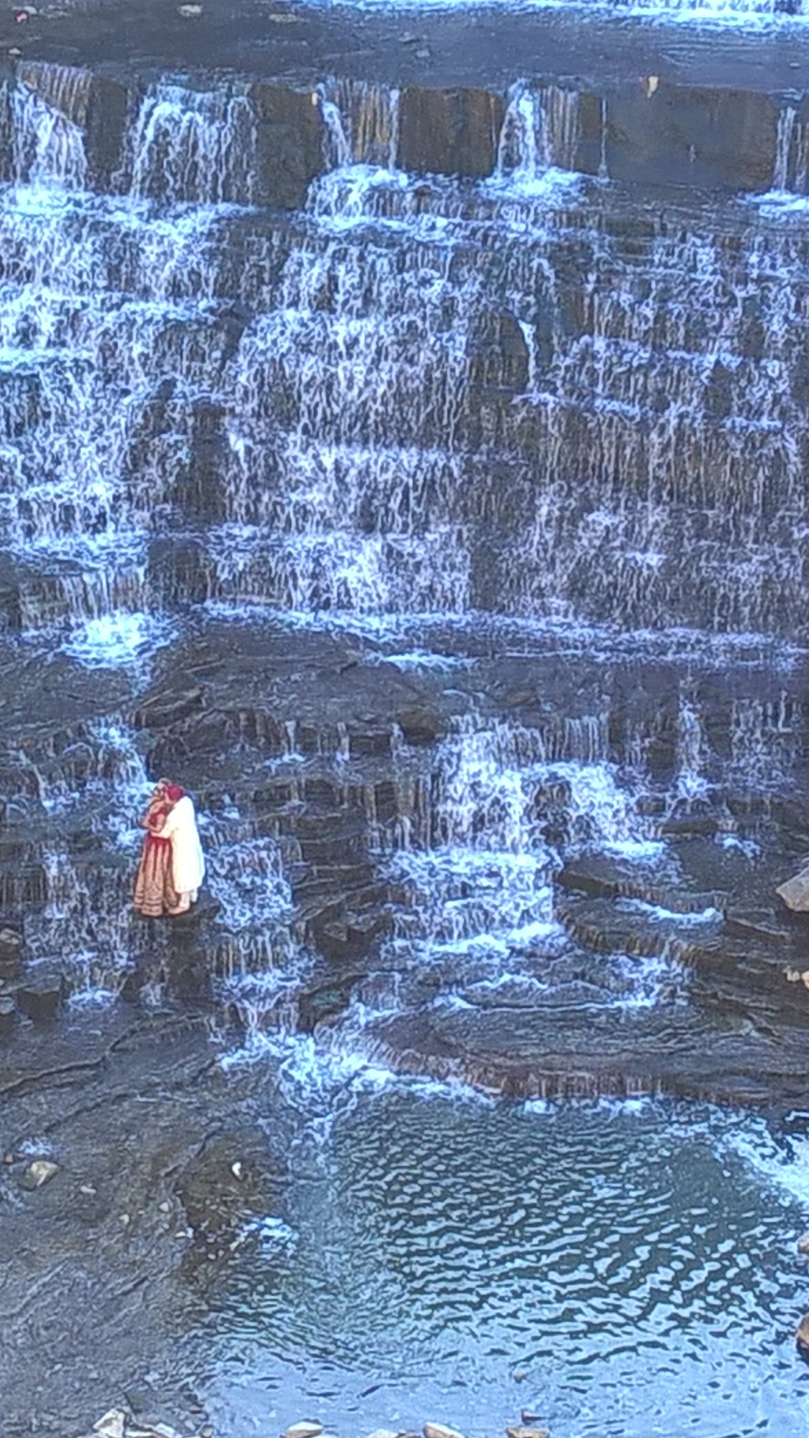
Pawtucket Falls
By Armen Suny · Last verified May 2026
Photo Credits (1)
Difficulty
Drive Up
Trail Length
0.1 miles
Trail Type
Out And Back
Elevation Gain
10 ft
About Pawtucket Falls
Pawtucket Falls sits on the Blackstone River in Pawtucket, Rhode Island, and is a key feature of the Blackstone River Valley’s industrial landscape. Rather than a single tall drop, the falls present a series of cascading rapids whose flow and character change with river levels; these rapids helped power mills during the American Industrial Revolution and remain an evocative reminder of the region’s history. The falls are easily seen from nearby roads and designated observation points, making them a compact, history-rich stop for a short visit. There’s no long backcountry approach here — most visitors view the falls from short walkways and roadside vantage points. A very short 0.1-mile route with about 10 feet of elevation gain provides access to the best viewpoints; the feature is essentially a drive-up sight with only a brief walk required. The nearest established campground is West Hill Park, roughly 31.9 km away, so plan overnight stays accordingly if you’re coming from farther away.
Trail & Hike Details
The Approach
No hiking required. Pawtucket Falls is accessible by vehicle with a roadside viewing area.
Trail Description
There is no formal USFS trail to Pawtucket Falls; instead the site is accessed from nearby roads and short walkways. Available route data lists a 0.1-mile length with approximately 10 feet of elevation gain and a difficulty described as “drive_up,” indicating vehicle access with only a brief on-foot approach. Trail type is recorded as unknown and no official USFS trail name/number, surface, grade, or technical trail class is listed for the viewing route, so expect a very short, low-grade stroll from parking or roadside observation points rather than a maintained hiking trail.
What to Expect
Visitors can expect to see a series of cascading rapids rather than a traditional tall waterfall. The falls are surrounded by urban infrastructure, and the area provides a mix of natural and industrial scenery. The flow of the falls may vary depending on the season and water levels in the Blackstone River.
Accessibility
This waterfall is viewable from a vehicle-accessible area. No hiking is required.
Frequently Asked Questions
🐶 Are Dogs Allowed at Pawtucket Falls?
❌ Dogs are not allowed
Are There Any Fees or Permits Required?
🆖 No fees required
🏊 Is There Swimming at Pawtucket Falls?
❌ Swimming is not allowed
When to Visit
Spring and fall are ideal times to visit due to pleasant weather and potentially higher water levels in the river.
Seasonal Access
The best time to visit is Spring, Summer, Fall, and Winter.
Safety Information
Exercise caution near the river, as the water can be fast-moving and the surrounding rocks may be slippery. Avoid entering the water.
Current Water Conditions
154 ft³/s
Current discharge — how much water is flowing
Much lower than usual for this time of year
Based on 21 years of record
0.75 ft
Water depth at gauge
7-Day Discharge Trend
What does this mean for your visit?
Flow is well below normal for this time of year, so the waterfall may be a trickle.
About This Gauge
7-Day Flow Outlook
Based on the USGS gauge BLACKSTONE R AT ROOSEVELT ST AT PAWTUCKET RI (1 km away).
Today
Barely Flowing
155 cfs
5/10Tomorrow
Low
189 cfs
3/10Sun
Low
185 cfs
4/10Mon
Barely Flowing
151 cfs
5/10Tue
Low
175 cfs
3/10Wed
Low
157 cfs
4/10Thu
Low
146 cfs
4/10Best window: Today — barely flowing flow, sunny (trip score 5/10).
Best time of year: this gauge typically runs highest from mid March to early May, peaking in April.
How we calculate this
This is a transparent outlook, not a precise forecast. We take the waterfall's current flow strength (how it ranks against its historical normal for today, from the nearest USGS stream gauge), carry that ranking forward along the gauge's seasonal curve, and nudge it for forecast rain. Confidence is highest for the next day or two and falls further out. Always check official conditions and your own judgment before visiting — high flows can be dangerous.
Know when to go.
Get a free email alert when waterfalls near Pawtucket hit peak flow. We only send when conditions are worth the trip — no weekly newsletters, no spam.
Weather Forecast
Location & Access
Getting There
Pawtucket Falls is located near downtown Pawtucket, Rhode Island, and is easily accessible by car. The falls are situated near the intersection of Roosevelt Avenue and Main Street, close to the Slater Mill Historic Site.
Get Directions on Google MapsParking
There is limited parking available near the falls, including street parking and parking lots near the Slater Mill Historic Site.
Hours
Elevation
3 feet above sea level
Coordinates
41.876489° N, -71.383389° W
Visitor Tips & Gear
Visit during the spring or after heavy rains for the most impressive water flow. Combine your visit with a trip to the nearby Slater Mill Historic Site to learn more about the area's industrial history.
As an Amazon Associate, we earn from qualifying purchases.
For this easy 0.1 miles trail, lightweight trail shoes and a water bottle are usually sufficient. Icy conditions are common in winter — traction cleats are a smart addition.

Columbia Watertight II Rain Jacket
Packs into its own pocket, seam-sealed, and keeps you dry from spray and surprise rain.

Polarized Sunglasses (Knockaround)
Cuts glare off the water so you actually see the falls — and your photos turn out better too.

Earth Pak Waterproof Dry Bag
Keeps your phone and gear dry when waterfall mist soaks everything else.

Waterproof Phone Pouch (AiRunTech)
Cheap insurance — take photos right next to the falls without killing your phone.

Kahtoola MICROspikes
Cult-favorite traction cleats that grip ice and wet rock — essential for winter waterfall hikes.

JOBY GorillaPod Starter Kit
Wraps around railings and rocks for long-exposure waterfall shots — no flat surface needed.
Where to Stay

Bally's Twin River Lincoln Casino & Hotel

Hampton Inn North Attleboro, Ma

Courtyard by Marriott Providence Lincoln

Hilton Garden Inn Providence
Browse vacation cabins and private rentals nearby
Unique outdoor stays — tents, yurts, and treehouses
Rent a campervan or RV for your waterfall road trip
Some links are affiliate links. We may earn a commission at no extra cost to you.
Nearby Campground
WEST HILL PARK
19.8 miles away · 3 sites
Overview On a quiet back road and across an old fieldstone bridge lies West Hill Park, where the West River widens to form a large, natural pool. The park and its many services and activities, including a swimming beach, accessible playground, nature trails and calm, clean water, attract visitors of all ages. Three group shelters, one near the dam, are ideal facilities for hosting graduation parties, family reunions and church or other organization events. The recreation area can be reserved duri
Book on Recreation.govAdditional Information
Nearby Attractions
Slater Mill Historic Site, Blackstone River Valley National Historical Park, and local shops and restaurants in downtown Pawtucket.
Wildlife
The area is urban, so wildlife sightings are limited, but visitors may see birds such as ducks and geese near the river.
Cities near Pawtucket Falls
Nearby Waterfalls
Other waterfalls named Pawtucket Falls
1 other waterfall shares this name across the U.S.
Writing about Pawtucket Falls? Embed this waterfall on your site for free.