
Photo Credits (1)
Difficulty
Moderate
Trail Length
2.0 miles
Trail Type
Out And Back
Elevation Gain
300 ft
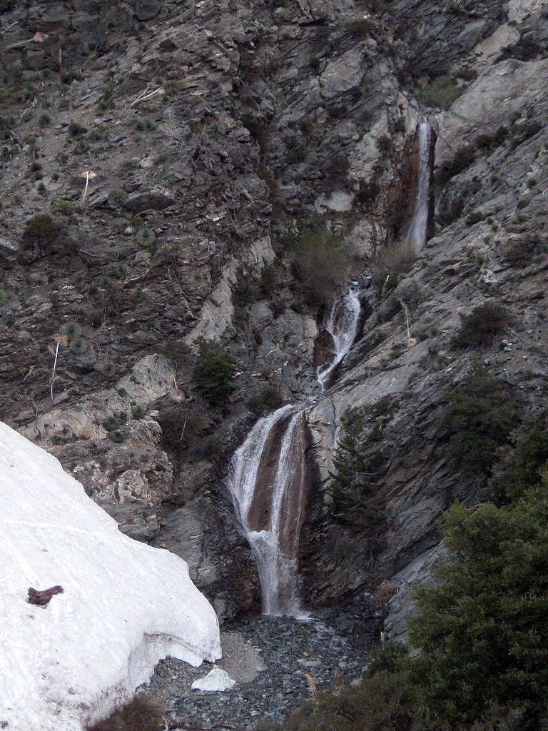
About Wolfskill Falls
Tucked into the Angeles National Forest and managed by the U.S. Forest Service, Wolfskill Falls is a quiet, lesser-known cascade that offers a peaceful retreat amid riparian vegetation and canyon scenery. Its modest size and secluded setting make it a rewarding short outing for hikers who want a scenic destination without the crowds. The approach is a moderate, 2.0-mile out-and-back that climbs roughly 300 feet, so it’s well suited to anyone comfortable with moderate terrain and a short hike. Because the falls and access trail lie on USFS land, conditions and access can change seasonally—check with the Angeles National Forest for current trail status before you go.
The Setting
Wolfskill Falls sits at 2,028 feet within Angeles National Forest, in the hills of California.
Nearby Falls Worth Visiting
San Antonio Falls (75 ft) lies 9.3 miles to the northeast.
Trail & Hike Details
The Approach
The moderate 2.0-mile out-and-back trail gains 300 feet of elevation on the way to the falls.
Trail Description
Distance: 2.0 miles (out-and-back). Elevation gain: approximately 300 feet. Difficulty: Moderate. Land unit/manager: Angeles National Forest, managed by the U.S. Forest Service. USFS trail surface, grade, and technical class are not specified in the available USFS data; hikers should expect a moderate, short canyon route and consult the Forest Service for the latest trail conditions and any advisories.
What to Expect
Visitors can expect a peaceful hike with beautiful natural surroundings, including native plants and occasional wildlife sightings. The waterfall itself is a tranquil spot, ideal for relaxation and photography.
Accessibility
The trail is not wheelchair accessible. Uneven terrain and elevation changes require steady footing.
Frequently Asked Questions
🐶 Are Dogs Allowed at Wolfskill Falls?
❌ Dogs are not allowed
Are There Any Fees or Permits Required?
🆖 No fees required
🏊 Is There Swimming at Wolfskill Falls?
❌ Swimming is not allowed
When to Visit
Spring is the best time to visit, as the waterfall is likely to have the most water flow due to seasonal rains. Summer and fall may also be good, but water levels could be lower.
Seasonal Access
The best time to visit is Spring, Summer, and Fall. Winter access may be limited. Check with Angeles National Forest for seasonal road closures.
Safety Information
The trail may have loose rocks and narrow sections, so proper footwear and caution are essential. Check weather conditions before visiting, as rain can make the trail slippery.
Current Water Conditions
5 ft³/s
Current discharge — how much water is flowing
About average for this time of year
Based on 47 years of record
16.72 ft
Water depth at gauge
7-Day Discharge Trend
What does this mean for your visit?
Flow is about average for this time of year.
About This Gauge
This gauge is on a nearby waterway and may not reflect exact conditions at the falls.
7-Day Flow Outlook
Based on the USGS gauge CUCAMONGA C NR UPLAND CA (11 km away).
Today
Roaring
5 cfs
9/10Tomorrow
Roaring
5 cfs
9/10Tue
Roaring
5 cfs
9/10Wed
Roaring
4 cfs
9/10Thu
Roaring
4 cfs
9/10Fri
Roaring
4 cfs
9/10Sat
Roaring
4 cfs
9/10Best window: Today — roaring flow, partly sunny (trip score 9/10).
Best time of year: this gauge typically runs highest from early February to early May, peaking in February.
How we calculate this
This is a transparent outlook, not a precise forecast. We take the waterfall's current flow strength (how it ranks against its historical normal for today, from the nearest USGS stream gauge), carry that ranking forward along the gauge's seasonal curve, and nudge it for forecast rain. Confidence is highest for the next day or two and falls further out. Always check official conditions and your own judgment before visiting — high flows can be dangerous.
Know when to go.
Get a free email alert when waterfalls near La Verne hit peak flow. We only send when conditions are worth the trip — no weekly newsletters, no spam.
Weather Forecast
Location & Access
Getting There
Wolfskill Falls is located in the Wolfskill Canyon area of California. Access typically involves driving to a trailhead near the canyon, but specific directions may vary depending on the starting point.
Get Directions on Google MapsParking
Parking availability is uncertain, but visitors may find parking near the trailhead. It is recommended to arrive early, especially during weekends or peak seasons.
Elevation
2,028 feet above sea level
Coordinates
34.175840° N, -117.749502° W
Land Management
Managed by USFS
Visitor Tips & Gear
Wear sturdy hiking shoes and bring plenty of water, especially during warmer months. Check trail conditions before visiting, as the area may be affected by seasonal weather or maintenance.
As an Amazon Associate, we earn from qualifying purchases.
With 2.0 miles and 300 ft of elevation gain, sturdy boots and trekking poles will help on this moderate trail. Sun exposure on the trail makes good sun protection a must in summer.

Polarized Sunglasses (Knockaround)
Cuts glare off the water so you actually see the falls — and your photos turn out better too.

Columbia Watertight II Rain Jacket
Packs into its own pocket, seam-sealed, and keeps you dry from spray and surprise rain.

Earth Pak Waterproof Dry Bag
Keeps your phone and gear dry when waterfall mist soaks everything else.

Waterproof Phone Pouch (AiRunTech)
Cheap insurance — take photos right next to the falls without killing your phone.

Timberland Euro Sprint Mid Waterproof
Trusted waterproof boot with premium leather and grippy rubber sole — reliable on rocky, wet trails.

TrailBuddy Trekking Poles
Lightweight aluminum, cork grips, and flip-locks that actually hold — a best-seller for good reason.
Where to Stay

La Quinta Inn & Suites by Wyndham Ontario Airport

Holiday Inn Ontario Airport - California by IHG

DoubleTree by Hilton Claremont

Country Inn & Suites by Radisson, Ontario at Ontario Mills, CA
Browse vacation cabins and private rentals nearby
Unique outdoor stays — tents, yurts, and treehouses
Rent a campervan or RV for your waterfall road trip
Some links are affiliate links. We may earn a commission at no extra cost to you.
Nearby Campground
San Gabriel Mountains National Monument
7 miles away · 0 sites
San Gabriel Mountains National Monument Office is located at 110 N. Wabash Ave., Glendora, CA 91741(626) 335-1251, Ext. 221CRS (800) 735-2922 (Voice) CRS (800) 735-2929 (TDD/TTY)FAX (626) 914-3790
Book on Recreation.govNearby Hot Springs
Hot springs near La Verne, California

Tylers Bath Spring
Tyler's Bath Spring emerges at 92 degrees in the San Bernardino National Forest, producing water 30 degrees warmer than the amb...

Arrowhead Springs, Waterman Hot Spr
Arrowhead Springs and Waterman Hot Springs discharge at 194°F (90°C) in the San Bernardino Mountains, among Southern California...
Radium Sulphur Springs
Radium Sulphur Springs occupies a remarkable position immediately alongside Melrose Avenue in Hollywood, emerging virtually roa...
Unnamed Spring San Bernardino County
Deep in the San Bernardino National Forest near Mentone, this 90-degree spring flows 26 degrees above ambient in mountains wher...
Glen Ivy Hot Springs
Glen Ivy Hot Springs emerges at 131 degrees Fahrenheit, the warmest feature among these Riverside County springs and displaying...
Fairview Hot Spring
Fairview Hot Spring represents a unique geothermal oddity in Orange County: an artesian well that tapped heated groundwater and...
Looking for a soak after your hike? Explore more hot springs near La Verne, California on SoakingSprings.
Explore California springsAdditional Information
Nearby Attractions
The surrounding Wolfskill Canyon area offers additional hiking opportunities and scenic views.
Wildlife
The area may feature local wildlife such as birds, deer, and small mammals. Be cautious of potential encounters with snakes.
Cities near Wolfskill Falls
Nearby Waterfalls
Writing about Wolfskill Falls? Embed this waterfall on your site for free.