Waternomee Falls
By Armen Suny · Last verified May 2026
Difficulty
Moderate
Trail Length
3.2 miles
Trail Type
Out And Back
Elevation Gain
600 ft
About Waternomee Falls
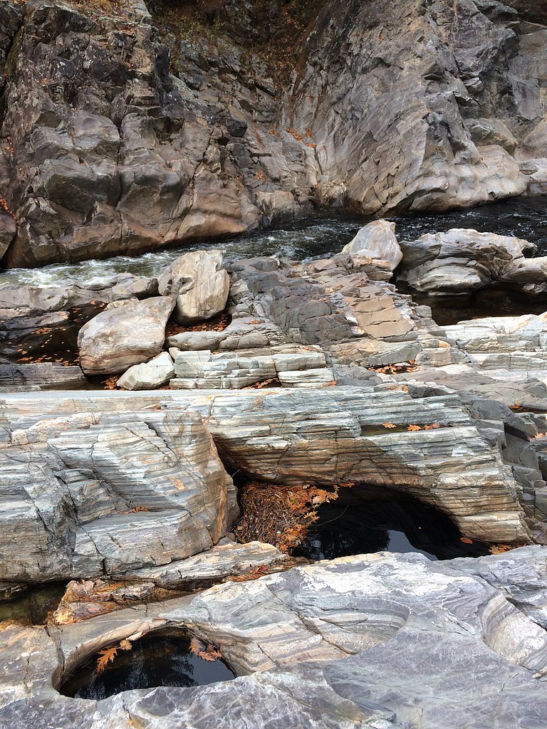
Waternomee Falls is a picturesque series of cascades located in the White Mountains of New Hampshire. It is part of the scenic White Mountain National Forest and is a popular destination for hikers seeking a moderate trail with rewarding views.
The Setting
Waternomee Falls sits at 1,575 feet within White Mountain National Forest, fed by the Baker River, in the hills of New Hampshire.
Trail & Hike Details
The Approach
The moderate hike follows Carr Mtn Trail Spur A (#32160A), a 3.2-mile out-and-back trail over natural surface. Expect 600 feet of elevation gain with grades of 0-5%. The trail is developed (Class 3).
USFS Trail
CARR MTN TRAIL SPUR A #32160A
Trail Class
Developed
Surface
Avg Grade
USFS Segment
0.11 miTrail Description
The trail to Waternomee Falls is a moderately challenging hike through a forested area. The path includes some rocky and root-filled sections, with a steady incline leading to the falls. The trail is well-shaded and offers a peaceful experience surrounded by nature.
What to Expect
Dogs are welcome.
Accessibility
The trail is not wheelchair accessible. Uneven terrain and elevation changes require steady footing.
Frequently Asked Questions
🐶 Are Dogs Allowed at Waternomee Falls?
✅ Dogs are allowed
Are There Any Fees or Permits Required?
🆖 No fees required
🏊 Is There Swimming at Waternomee Falls?
❌ Swimming is not allowed
When to Visit
Spring and early summer are the best times to visit, as the falls are typically at their fullest due to snowmelt and rainfall.
Seasonal Access
The best time to visit is Spring, Summer, and Fall. Winter access may be limited. Check with White Mountain National Forest for seasonal road closures.
Safety Information
The trail can be slippery near the falls, especially after rain. Wear appropriate footwear and exercise caution. Cell service may be limited, so inform someone of your plans before heading out.
Current Water Conditions
304 ft³/s
Current discharge — how much water is flowing
Higher than usual for this time of year
Based on 73 years of record
1.55 ft
Water depth at gauge
7-Day Discharge Trend
What does this mean for your visit?
The water is flowing higher than usual for this time of year.
About This Gauge
This gauge is on a nearby waterway and may not reflect exact conditions at the falls.
7-Day Flow Outlook
Based on the USGS gauge BAKER RIVER NEAR RUMNEY, NH (11 km away).
Today
Barely Flowing
308 cfs
5/10Tomorrow
Barely Flowing
319 cfs
3/10Tue
Low
367 cfs
3/10Wed
Low
335 cfs
3/10Thu
Low
340 cfs
4/10Fri
Low
302 cfs
3/10Sat
Low
280 cfs
4/10Best window: Today — barely flowing flow, sunny (trip score 5/10).
Best time of year: this gauge typically runs highest from mid March to early June, peaking in April.
How we calculate this
This is a transparent outlook, not a precise forecast. We take the waterfall's current flow strength (how it ranks against its historical normal for today, from the nearest USGS stream gauge), carry that ranking forward along the gauge's seasonal curve, and nudge it for forecast rain. Confidence is highest for the next day or two and falls further out. Always check official conditions and your own judgment before visiting — high flows can be dangerous.
Know when to go.
Get a free email alert when waterfalls near North Woodstock hit peak flow. We only send when conditions are worth the trip — no weekly newsletters, no spam.
Weather Forecast
Location & Access
Getting There
The trailhead for Waternomee Falls is located off Walker Brook Road in Woodstock, New Hampshire. Access may require driving on unpaved roads, and the trailhead is typically marked but can be easy to miss.
Get Directions on Google MapsParking
Parking is available near the trailhead, but spaces are limited. Arrive early, especially during peak seasons, to secure a spot.
Elevation
1,575 feet above sea level
Coordinates
43.895069° N, -71.856472° W
Land Management
Managed by USFS
Visitor Tips & Gear
Wear sturdy hiking shoes, as the trail can be uneven and muddy in places. Bring bug spray during the summer months, and consider visiting in the morning to avoid crowds. Check weather conditions before your trip, as rain can make the trail more challenging.
As an Amazon Associate, we earn from qualifying purchases.
With 3.2 miles and 600 ft of elevation gain, sturdy boots and trekking poles will help on this moderate trail. Sun exposure on the trail makes good sun protection a must in summer.

Columbia Watertight II Rain Jacket
Packs into its own pocket, seam-sealed, and keeps you dry from spray and surprise rain.

Earth Pak Waterproof Dry Bag
Keeps your phone and gear dry when waterfall mist soaks everything else.

Waterproof Phone Pouch (AiRunTech)
Cheap insurance — take photos right next to the falls without killing your phone.

Timberland Euro Sprint Mid Waterproof
Trusted waterproof boot with premium leather and grippy rubber sole — reliable on rocky, wet trails.

TrailBuddy Trekking Poles
Lightweight aluminum, cork grips, and flip-locks that actually hold — a best-seller for good reason.

Sawyer Squeeze Water Filter
The backcountry standard — filters 99.9% of bacteria and weighs just 3 oz.
Where to Stay

Inn 32

Holiday Inn Express & Suites - Lincoln East - White Mountains by IHG

Bluegreen Vacations South Mountain, an Ascend Collection Resort

The Lakeview Inn & Cottages
Browse vacation cabins and private rentals nearby
Unique outdoor stays — tents, yurts, and treehouses
Rent a campervan or RV for your waterfall road trip
Some links are affiliate links. We may earn a commission at no extra cost to you.
Nearby Campground
CAMPTON CAMPGROUND
11.5 miles away · 91 sites
Overview Campton Campground is a large and accommodating facility near the southern edge of White Mountain National Forest in New Hampshire. With many kid-friendly activities nearby such as hiking and nature programs, the campground is especially popular with families. It is convenient to U.S. Highway 93, which travels through the middle of the state, and is just two hours from Boston. The White Mountains boast pristine forests, clear mountain streams and rivers and the tallest peaks in the North
Book on Recreation.govAdditional Information
Nearby Attractions
Nearby attractions include Franconia Notch State Park, the Flume Gorge, and the Kancamagus Highway, which offers stunning scenic drives.
Wildlife
The area is home to a variety of wildlife, including birds, deer, and small mammals. Be cautious of black bears, which are occasionally spotted in the region.
Cities near Waternomee Falls
Nearby Waterfalls
Writing about Waternomee Falls? Embed this waterfall on your site for free.