
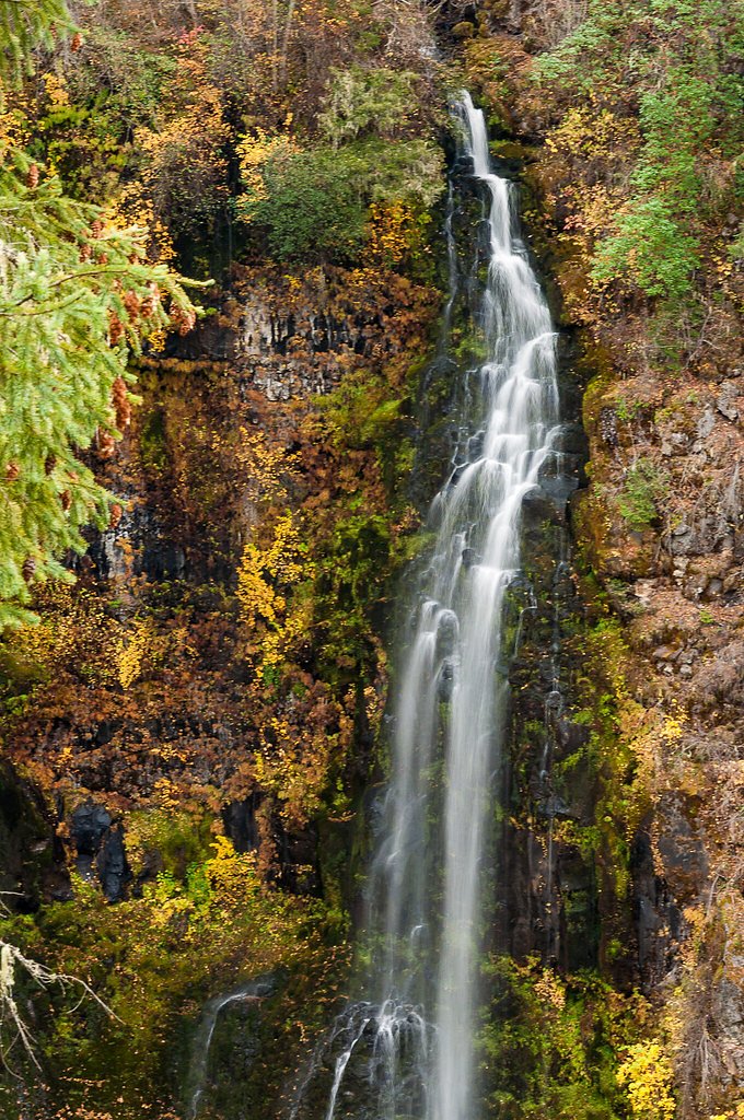
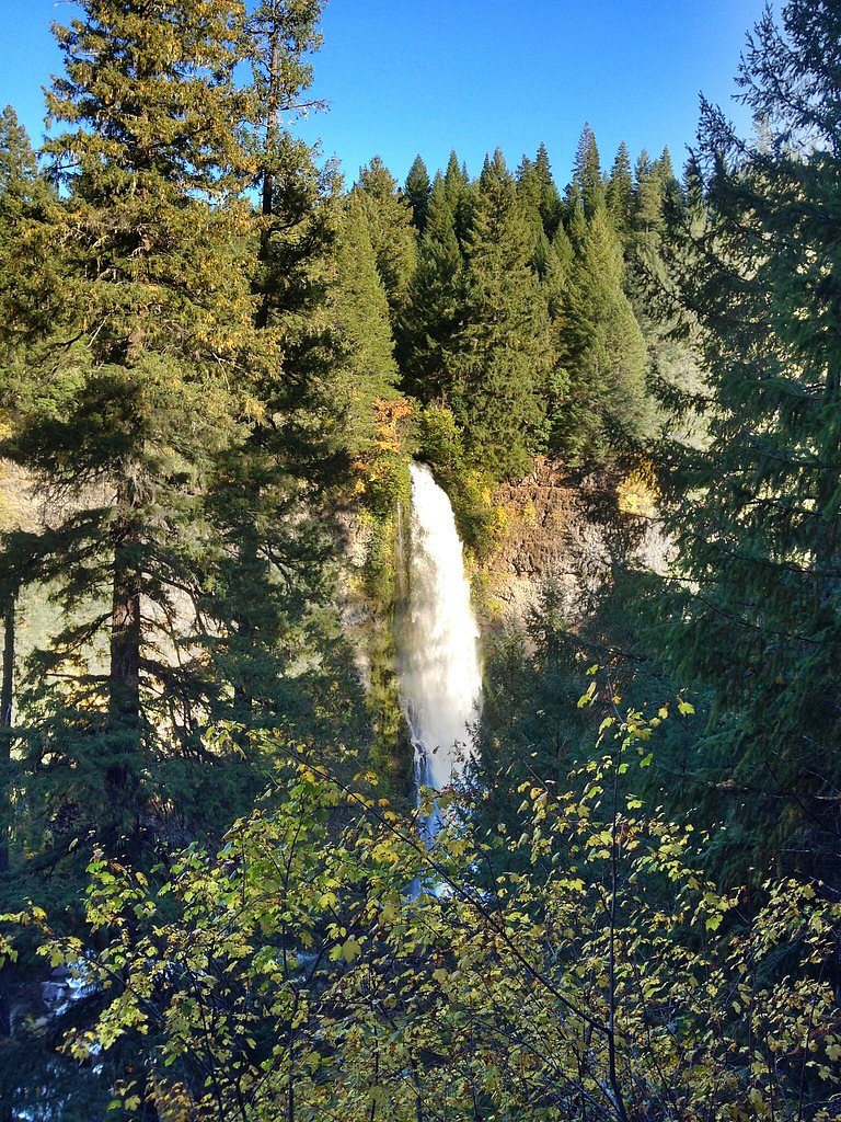
Turner Drop
Oregon • Crater Lake National Park
By Armen Suny · Last verified May 2026
Difficulty
Moderate
Trail Length
2.4 miles
Trail Type
Out And Back
Elevation Gain
350 ft
About Turner Drop
Turner Drop is a tucked-away cascade on the Little North Santiam River tucked within the Rogue River National Forest and managed by the U.S. Forest Service. Surrounded by dense, mixed-conifer forest, the falls are a quiet reward for hikers willing to leave the busier corridors; the nearest developed camping is the Jim Creek Group Campground, just 0.88 km away, making this a convenient option for an overnight outing. Access follows a mix of forest track and singletrack rather than a paved walkway, so the experience feels remote and forested rather than heavily developed. Most approaches use the USFS MOTOCROSS TRACK OHV (Trail #1P) as part of the route. The outing is commonly done as a 2.4-mile out-and-back with about 350 feet of elevation gain and is rated moderate in difficulty—an inviting half-day hike for hikers comfortable with native-surface trails and shared OHV corridors. Because the primary access includes an OHV-designated track, expect rugged tread and occasional motorized traffic; plan accordingly and enjoy the leafy, low-key setting the Rogue River NF offers.
The Setting
Turner Drop sits at 2,976 feet within Crater Lake National Park, fed by the Rogue River, in the hills of Oregon.
Nearby Falls Worth Visiting
Barr Creek Falls (240 ft) lies 8.2 miles to the south. Also nearby: Mill Creek Falls (173 ft, 8.7 mi).
Trail & Hike Details
The Approach
The moderate hike follows Motocross Track Ohv (#1P), a 2.4-mile out-and-back trail over natural surface. Expect 350 feet of elevation gain. The trail is developed (Class 3).
USFS Trail
MOTOCROSS TRACK OHV #1P
Trail Class
Developed
Surface
USFS Segment
0.68 miTrail Description
The primary approach uses the USFS MOTOCROSS TRACK OHV (Trail #1P). That OHV track is classified as Class 3 with a native-material surface and is mapped at roughly 0.68 GIS miles along the initial portion of the route. The complete route to Turner Drop is typically described as a 2.4-mile out-and-back with about 350 feet of elevation gain and a moderate difficulty rating. Trail surface is native material—expect dirt, roots, and occasional ruts from motorized use rather than boardwalks or paved tread. The Class 3 designation and OHV designation mean the path can be rough and shared with off-highway vehicles; hikers should be prepared for variable footing and brief, steeper sections within the overall moderate grade. Jim Creek Group Campground sits about 0.88 km from the falls for nearby overnight camping.
What to Expect
Expect a serene and remote waterfall surrounded by dense forest. The area may be less crowded compared to more popular waterfalls in Oregon, offering a peaceful experience.
Accessibility
The trail is not wheelchair accessible. Uneven terrain and elevation changes require steady footing.
Frequently Asked Questions
🐶 Are Dogs Allowed at Turner Drop?
❌ Dogs are not allowed
Are There Any Fees or Permits Required?
🆖 No fees required
🏊 Is There Swimming at Turner Drop?
❌ Swimming is not allowed
When to Visit
Spring and early summer are ideal for visiting Turner Drop, as the waterfall is likely to have a stronger flow due to snowmelt and seasonal rains.
Seasonal Access
The best time to visit is Spring, Summer, and Fall. Winter access may be limited. Check with Crater Lake National Park for current conditions.
Safety Information
Trails may be unmarked and slippery, especially after rain. Be cautious of stream crossings and steep sections. Cell service may be limited, so inform someone of your plans before visiting.
Current Water Conditions
688 ft³/s
Current discharge — how much water is flowing
Much lower than usual for this time of year
Based on 74 years of record
1.53 ft
Water depth at gauge
53°F
ColdBracing — limit time in water
7-Day Discharge Trend
What does this mean for your visit?
Flow is well below normal for this time of year, so the waterfall may be a trickle. Water temperature is a bracing 53 degrees F, limit your time in the water.
About This Gauge
This gauge is on a nearby waterway and may not reflect exact conditions at the falls.
7-Day Flow Outlook
Based on the USGS gauge ROGUE RIVER BELOW PROSPECT, OR (15 km away).
Today
Moderate
743 cfs
6/10Tomorrow
Moderate
805 cfs
6/10Sun
Moderate
764 cfs
6/10Mon
Moderate
685 cfs
9/10Tue
Moderate
652 cfs
9/10Wed
Moderate
641 cfs
9/10Thu
Moderate
641 cfs
9/10Best window: Mon — moderate flow, mostly sunny (trip score 9/10).
Best time of year: this gauge typically runs highest from early March to early June, peaking in May.
How we calculate this
This is a transparent outlook, not a precise forecast. We take the waterfall's current flow strength (how it ranks against its historical normal for today, from the nearest USGS stream gauge), carry that ranking forward along the gauge's seasonal curve, and nudge it for forecast rain. Confidence is highest for the next day or two and falls further out. Always check official conditions and your own judgment before visiting — high flows can be dangerous.
Know when to go.
Get a free email alert when waterfalls near Prospect hit peak flow. We only send when conditions are worth the trip — no weekly newsletters, no spam.
Weather Forecast
Location & Access
Getting There
Turner Drop is located in the Little North Santiam River area, near the Opal Creek Wilderness. Access may require navigating forest roads, and specific directions should be verified before visiting.
Get Directions on Google MapsParking
Parking availability is unclear, but visitors may need to park along forest roads or at nearby trailheads. Ensure to follow posted signs and avoid blocking access.
Elevation
2,976 feet above sea level
Coordinates
42.865278° N, -122.501111° W
Land Management
Managed by USFS
Visitor Tips & Gear
Bring a detailed map or GPS device as trails may be unmarked. Wear sturdy footwear and prepare for uneven terrain. Check weather conditions before visiting, as rain can make trails slippery.
As an Amazon Associate, we earn from qualifying purchases.
With 2.4 miles and 350 ft of elevation gain, sturdy boots and trekking poles will help on this moderate trail. Sun exposure on the trail makes good sun protection a must in summer.

Polarized Sunglasses (Knockaround)
Cuts glare off the water so you actually see the falls — and your photos turn out better too.

Columbia Watertight II Rain Jacket
Packs into its own pocket, seam-sealed, and keeps you dry from spray and surprise rain.

Earth Pak Waterproof Dry Bag
Keeps your phone and gear dry when waterfall mist soaks everything else.

Waterproof Phone Pouch (AiRunTech)
Cheap insurance — take photos right next to the falls without killing your phone.

Timberland Euro Sprint Mid Waterproof
Trusted waterproof boot with premium leather and grippy rubber sole — reliable on rocky, wet trails.

TrailBuddy Trekking Poles
Lightweight aluminum, cork grips, and flip-locks that actually hold — a best-seller for good reason.
Where to Stay

Union Creek Resort

Rustic Cabin Rental in a Wild Meadow near Crater Lake National Park, Oregon

Luxury Cabin Rental in the Cascade Mountains near Crater Lake, Southern Oregon

Pet-Friendly House w/ Deck: Near Crater Lake!
Browse vacation cabins and private rentals nearby
Unique outdoor stays — tents, yurts, and treehouses
Rent a campervan or RV for your waterfall road trip
Some links are affiliate links. We may earn a commission at no extra cost to you.
Nearby Campground
JIM CREEK GROUP CAMPGROUND
0.5 miles away · 1 sites
Overview Jim Creek Group Campground provides your group with a peaceful camping experience in the Rogue River-Siskiyou National Forest. Recreation Woodruff Bridge picnic area is nearby and provides access to the Upper Rogue River Trail. The Upper Rogue River Trail (USFS #1034) mostly parallels the Rogue River for about 47 miles from near the river’s headwaters at Boundary Springs in Crater Lake National Park to the North Fork Dam outside Prospect, Oregon. A managed off-highway vehicle (OHV) trai
Book on Recreation.govNearby Hot Springs
Hot springs near Prospect, Oregon

Annie Spring
Annie Spring flows at 77°F within Crater Lake National Park at 5,983 feet elevation, discharging 1.71 cubic feet per second at ...

Umpqua Hot Springs
Umpqua Hot Springs flows at 117°F from multiple geothermal sources along the North Umpqua River in Lane County, forming cascadi...
Jackson Hot Springs
Jackson Hot Springs registers 95°F with highly alkaline chemistry, posting pH 9.3 in sodium-dominated waters containing 95 mg/L...
Eagle Point Spring
Eagle Point Spring flows at 95°F in Klamath County, emerging 45.6°F above the 49.4°F ambient temperature in a climate receiving...
Howard Holiday
Howard Holiday flows at 77°F in Klamath County near Klamath Falls, emerging at 4,107 feet elevation approximately 157 meters fr...
Hardboard Spring
Hardboard Spring flows at 70°F from roadside terrain 36 meters from the nearest road in Klamath County near Klamath Falls, emer...
Looking for a soak after your hike? Explore more hot springs near Prospect, Oregon on SoakingSprings.
Explore Oregon springsAdditional Information
Nearby Attractions
Nearby attractions include Opal Creek Wilderness and other waterfalls in the Little North Santiam River area.
Wildlife
The area is home to a variety of wildlife, including birds, deer, and small mammals. Be cautious of potential encounters with bears or other larger animals.
Cities near Turner Drop
Nearby Waterfalls
Writing about Turner Drop? Embed this waterfall on your site for free.