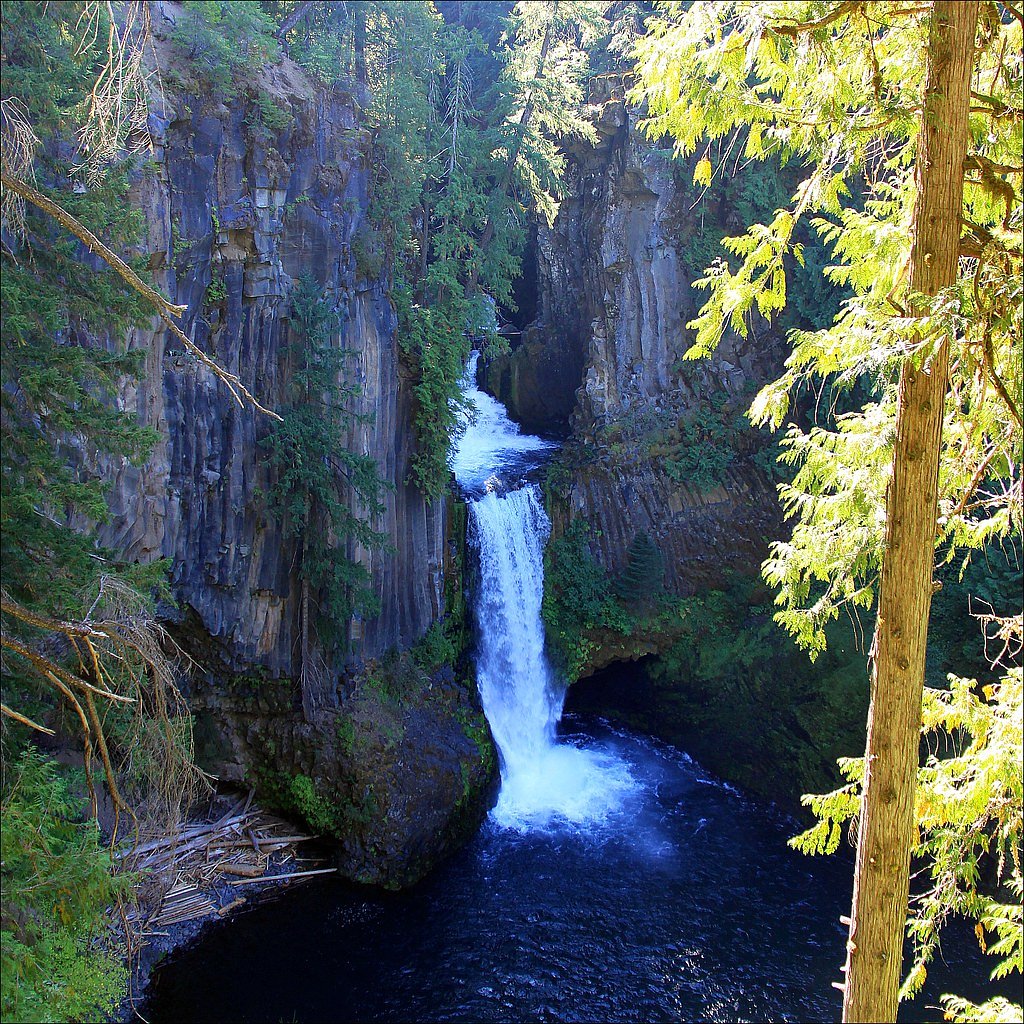
Toketee Falls
Oregon • 113 ft
By Armen Suny · Last verified Mar 2026
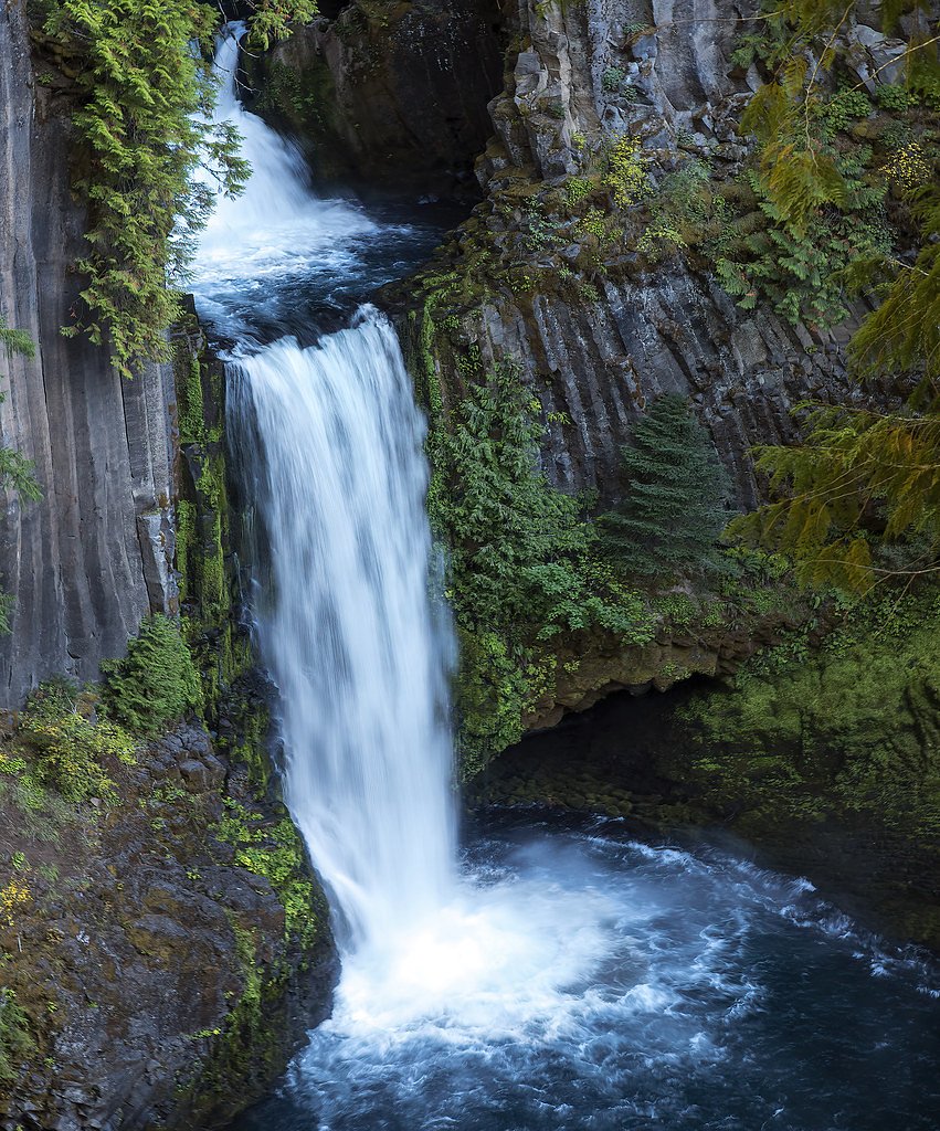
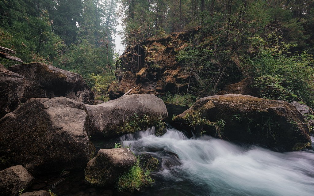
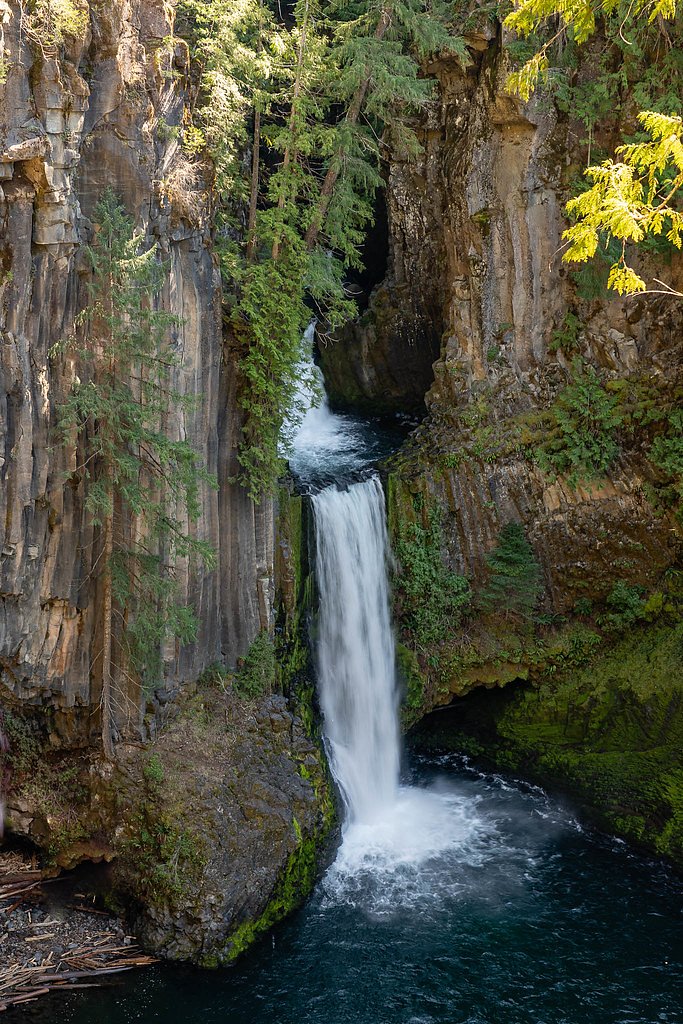
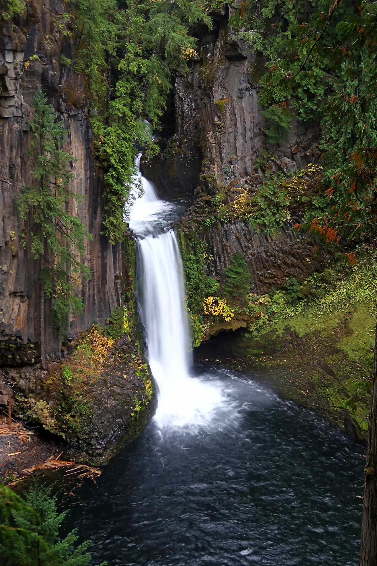
Photo Credits (5)
Difficulty
Easy
Trail Length
0.8 miles
Trail Type
Out And Back
Elevation Gain
200 ft
About Toketee Falls
Toketee Falls is a stunning two-tiered waterfall located in the Umpqua National Forest in Oregon. It is renowned for its unique basalt column formations and consistent water flow, fed by the North Umpqua River. The upper tier drops approximately 28 feet, while the lower tier plunges 85 feet into a deep, picturesque pool.
The Setting
Toketee Falls sits at 2,326 feet within Umpqua National Forest, fed by the North Umpqua River, in the hills of Oregon. At 113 feet, it is among the taller waterfalls in Oregon.
Height: 113 feet
Nearby Falls Worth Visiting
Watson Falls (272 ft) lies 2.6 miles to the southeast. Also nearby: Whitehorse Falls (15 ft, 6.5 mi).
Trail & Hike Details
The Approach
The easy hike follows Toketee Lake (#1447), a 0.8-mile out-and-back trail over natural surface. Expect 200 feet of elevation gain with grades of 12-20%. The trail is developed (Class 3).
USFS Trail
TOKETEE LAKE #1447
Trail Class
Developed
Surface
Avg Grade
USFS Segment
0.36 miTrail Description
The trail to Toketee Falls is a short and well-maintained path that winds through a lush forest. It includes a series of wooden stairs and a viewing platform at the end, offering a spectacular view of the falls. The trail is suitable for most visitors, though the stairs may be challenging for some.
What to Expect
The falls cascade 113 feet. Dogs are welcome.
Accessibility
The trail is not wheelchair accessible. Uneven terrain and elevation changes require steady footing.
Frequently Asked Questions
🐶 Are Dogs Allowed at Toketee Falls?
✅ Dogs are allowed
Are There Any Fees or Permits Required?
🆖 No fees required
🏊 Is There Swimming at Toketee Falls?
❌ Swimming is not allowed
When to Visit
Toketee Falls is beautiful year-round, but spring and early summer offer the best water flow and vibrant greenery. Fall provides colorful foliage, while winter may bring snow, adding a magical touch to the scenery.
Seasonal Access
The best time to visit is Spring, Summer, Fall, and Winter. Check with Umpqua National Forest for seasonal road closures.
Safety Information
Stay on the designated trail and observation platform. The area around the falls can be slippery and dangerous. Do not attempt to climb down to the base of the falls.
Current Water Conditions
89 ft³/s
Current discharge — how much water is flowing
About average for this time of year
Based on 22 years of record
3.28 ft
Water depth at gauge
7-Day Discharge Trend
What does this mean for your visit?
Flow is about average for this time of year.
About This Gauge
7-Day Flow Outlook
Based on the USGS gauge NORTH UMPQUA RIVER AT TOKETEE FALLS, OR (1 km away).
Today
Moderate
102 cfs
6/10Tomorrow
Moderate
108 cfs
6/10Thu
Moderate
95 cfs
8/10Fri
Moderate
89 cfs
8/10Sat
Moderate
89 cfs
8/10Sun
Moderate
89 cfs
8/10Mon
Moderate
89 cfs
8/10Best window: Thu — moderate flow, patchy fog then sunny (trip score 8/10).
Best time of year: this gauge typically runs highest from early August to early October, peaking in June.
How we calculate this
This is a transparent outlook, not a precise forecast. We take the waterfall's current flow strength (how it ranks against its historical normal for today, from the nearest USGS stream gauge), carry that ranking forward along the gauge's seasonal curve, and nudge it for forecast rain. Confidence is highest for the next day or two and falls further out. Always check official conditions and your own judgment before visiting — high flows can be dangerous.
Know when to go.
Get a free email alert when waterfalls near Oakridge hit peak flow. We only send when conditions are worth the trip — no weekly newsletters, no spam.
Weather Forecast
Location & Access
Getting There
Toketee Falls is located off Highway 138 in the Umpqua National Forest. From Roseburg, Oregon, drive east on Highway 138 for about 58 miles. Look for signs for Toketee Falls and turn onto Forest Road 34. The trailhead is well-marked and has a small parking area.
Get Directions on Google MapsParking
There is a small parking lot at the trailhead, which can fill up quickly during peak seasons. Arrive early to secure a spot.
Elevation
2,326 feet above sea level
Coordinates
43.263169° N, -122.433310° W
Land Management
Managed by USFS
Visitor Tips & Gear
Arrive early to avoid crowds, especially during summer weekends. Wear sturdy shoes as the trail can be muddy after rain. Bring a camera to capture the stunning views from the observation platform.
As an Amazon Associate, we earn from qualifying purchases.
For this easy 0.8 miles trail, lightweight trail shoes and a water bottle are usually sufficient. Icy conditions are common in winter — traction cleats are a smart addition.

Columbia Watertight II Rain Jacket
Packs into its own pocket, seam-sealed, and keeps you dry from spray and surprise rain.

Polarized Sunglasses (Knockaround)
Cuts glare off the water so you actually see the falls — and your photos turn out better too.

Earth Pak Waterproof Dry Bag
Keeps your phone and gear dry when waterfall mist soaks everything else.

Waterproof Phone Pouch (AiRunTech)
Cheap insurance — take photos right next to the falls without killing your phone.

Kahtoola MICROspikes
Cult-favorite traction cleats that grip ice and wet rock — essential for winter waterfall hikes.

JOBY GorillaPod Starter Kit
Wraps around railings and rocks for long-exposure waterfall shots — no flat surface needed.
Where to Stay

Shelter Cove Resort & Marina

Umpqua's Last Resort - Wilderness Cabins, RV Park & Glamping
Browse vacation cabins and private rentals nearby
Unique outdoor stays — tents, yurts, and treehouses
Rent a campervan or RV for your waterfall road trip
Some links are affiliate links. We may earn a commission at no extra cost to you.
Nearby Campground
HORSESHOE BEND CAMPGROUND (OR)
9.9 miles away · 25 sites
Overview Horseshoe Bend Campground is situated in a stand of old growth Douglas fir, sugar pine, and deciduous trees, on the banks of the Wild & Scenic North Umpqua River. The campground offers the perfect setting for families, anglers, whitewater enthusiasts, and anyone who wants to escape and relax in their natural surroundings. Recreation Horseshoe Bend Campground is in a prime location for many outdoor activities including hiking, fly fishing, mountain biking, swimming, and whitewater rafting
Book on Recreation.govNearby Hot Springs
Hot springs near Oakridge, Oregon

Umpqua Hot Springs
Umpqua Hot Springs flows at 117°F from multiple geothermal sources along the North Umpqua River in Lane County, forming cascadi...
Kitson Hot Springs
Kitson Hot Springs flows at 109°F within Willamette National Forest at 1,664 feet elevation, positioned just 17 meters from For...

Mccredie Springs
McCredie Springs flows at 163°F along Salt Creek in the Willamette National Forest, creating one of western Oregon's most popul...

Annie Spring
Annie Spring flows at 77°F within Crater Lake National Park at 5,983 feet elevation, discharging 1.71 cubic feet per second at ...
Wall Creek Warm Springs
Wall Creek Warm Springs flows at 106°F deep within Willamette National Forest at 2,362 feet elevation on the western Cascades s...
Looking for a soak after your hike? Explore more hot springs near Oakridge, Oregon on SoakingSprings.
Explore Oregon springsAdditional Information
Nearby Attractions
Nearby attractions include Watson Falls, Umpqua Hot Springs, and the North Umpqua Trail.
Wildlife
The area is home to a variety of wildlife, including deer, birds, and small mammals. Keep an eye out for native species while hiking.
Cities near Toketee Falls
Nearby Waterfalls

Writing about Toketee Falls? Embed this waterfall on your site for free.