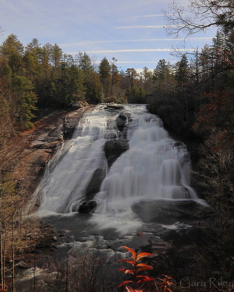
Thurston Hatcher Falls
By Armen Suny · Last verified May 2026
Difficulty
Moderate
Trail Length
2.4 miles
Trail Type
Out And Back
Elevation Gain
350 ft
About Thurston Hatcher Falls
Thurston Hatcher Falls is a tucked-away waterfall in North Carolina that rewards visitors with a quiet, forested setting and a peaceful plunge framed by mature hardwoods. It’s a great choice for hikers who want a less-crowded nature stop — the falls feel like a discovery after a short walk through the woods, and the seclusion makes it a nice spot for photography or a restful break. The most common approach to the falls is a moderate 2.4-mile out-and-back hike with about 350 feet of elevation gain. The route follows a forested tread with some uneven footing and short climbs; hikers comfortable with moderate grades and natural trails will find it accessible. There isn’t USFS trail name/number data provided for this route, so bring a map or GPS, sturdy shoes, and be prepared for basic route-finding in places.
The Setting
Thurston Hatcher Falls sits at 2,927 feet along the Tuckasegee River, in the hills of North Carolina.
Trail & Hike Details
The Approach
The moderate 2.4-mile out-and-back trail gains 350 feet of elevation on the way to the falls.
Trail Description
Out-and-back, 2.4 miles total with roughly 350 feet of elevation gain. Difficulty: moderate. The trail passes through forested terrain and includes uneven footing and short climbs—expect natural tread and some roots/rocks underfoot. No USFS trail surface/grade/class data are available for this approach, so plan for minimal infrastructure and basic wayfinding. Suitable for day hikers comfortable with moderate, unpaved trails.
What to Expect
Visitors can expect a peaceful and natural setting with a waterfall surrounded by forest. The area may be less crowded due to its lesser-known status.
Accessibility
The trail is not wheelchair accessible. Uneven terrain and elevation changes require steady footing.
Frequently Asked Questions
🐶 Are Dogs Allowed at Thurston Hatcher Falls?
❌ Dogs are not allowed
Are There Any Fees or Permits Required?
🆖 No fees required
🏊 Is There Swimming at Thurston Hatcher Falls?
❌ Swimming is not allowed
When to Visit
Spring and fall are typically the best times to visit, as the waterfall may have higher flow during these seasons.
Seasonal Access
The best time to visit is Spring, Summer, and Fall. Winter access may be limited.
Safety Information
Visitors should be cautious of slippery rocks near the waterfall and uneven terrain on the trail. Check weather conditions before visiting.
Current Water Conditions
75 ft³/s
Current discharge — how much water is flowing
Much lower than usual for this time of year
Based on 21 years of record
4.07 ft
Water depth at gauge
7-Day Discharge Trend
What does this mean for your visit?
Flow is well below normal for this time of year, so the waterfall may be a trickle.
About This Gauge
This gauge is on a nearby waterway and may not reflect exact conditions at the falls.
7-Day Flow Outlook
Based on the USGS gauge TUCKASEGEE RIVER AT SR 1172 NR CULLOWHEE, NC (9 km away).
Today
Moderate
86 cfs
6/10Tomorrow
Moderate
91 cfs
6/10Wed
Moderate
90 cfs
6/10Thu
Moderate
96 cfs
6/10Fri
Moderate
107 cfs
6/10Sat
Moderate
103 cfs
6/10Sun
Moderate
98 cfs
6/10Best window: Today — moderate flow, chance showers and thunderstorms (trip score 6/10).
Best time of year: this gauge typically runs highest from late December to late January, peaking in January.
How we calculate this
This is a transparent outlook, not a precise forecast. We take the waterfall's current flow strength (how it ranks against its historical normal for today, from the nearest USGS stream gauge), carry that ranking forward along the gauge's seasonal curve, and nudge it for forecast rain. Confidence is highest for the next day or two and falls further out. Always check official conditions and your own judgment before visiting — high flows can be dangerous.
Know when to go.
Get a free email alert when waterfalls near Glenville hit peak flow. We only send when conditions are worth the trip — no weekly newsletters, no spam.
Weather Forecast
Location & Access
Getting There
The exact location of Thurston Hatcher Falls is not well-documented. Visitors may need to consult local guides or hiking resources for directions.
Get Directions on Google MapsParking
Parking availability is unclear. Visitors should plan to park in nearby designated areas or along the road if permitted.
Elevation
2,927 feet above sea level
Coordinates
35.205931° N, -83.165145° W
Visitor Tips & Gear
Bring a map or GPS device as the trail may not be well-marked. Wear sturdy footwear and be prepared for potential muddy or uneven paths.
As an Amazon Associate, we earn from qualifying purchases.
With 2.4 miles and 350 ft of elevation gain, sturdy boots and trekking poles will help on this moderate trail. Sun exposure on the trail makes good sun protection a must in summer.

Columbia Watertight II Rain Jacket
Packs into its own pocket, seam-sealed, and keeps you dry from spray and surprise rain.

Earth Pak Waterproof Dry Bag
Keeps your phone and gear dry when waterfall mist soaks everything else.

Waterproof Phone Pouch (AiRunTech)
Cheap insurance — take photos right next to the falls without killing your phone.

Timberland Euro Sprint Mid Waterproof
Trusted waterproof boot with premium leather and grippy rubber sole — reliable on rocky, wet trails.

TrailBuddy Trekking Poles
Lightweight aluminum, cork grips, and flip-locks that actually hold — a best-seller for good reason.

Polarized Sunglasses (Knockaround)
Cuts glare off the water so you actually see the falls — and your photos turn out better too.
Where to Stay

Private Mtn Love Shack w/ fast wifi, BBQ & view

Chalet at Peek's Creek

The Lodge Nantahala River

Riverside Relaxer w/Hot Tub+Fire Pit +Wifi & view
Browse vacation cabins and private rentals nearby
Unique outdoor stays — tents, yurts, and treehouses
Rent a campervan or RV for your waterfall road trip
Some links are affiliate links. We may earn a commission at no extra cost to you.
Nearby Campground
BALSAM LAKE LODGE
9.3 miles away · 1 sites
Overview Balsam Lake Lodge is nestled in the center of the 39,000-acre Roy Taylor Forest within the Nantahala National Forest. The lodge overlooks Balsam Lake and offers spectacular mountain views.The lodge opened its doors to the public when the Forest Service acquired the dwelling and lake in 1982. Since then groups have rented the lodge for meetings, recreation and environmental activities. NOTE: Balsam Lake Lodge is not a campground and has no campsites available for sewer, water, or electric
Book on Recreation.govNearby Hot Springs
Hot springs near Glenville, North Carolina

Looking for a soak after your hike? Explore more hot springs near Glenville, North Carolina on SoakingSprings.
Explore North Carolina springsAdditional Information
Nearby Attractions
Other waterfalls and hiking trails in North Carolina may be nearby, but specific attractions are not documented.
Wildlife
The area may feature typical North Carolina wildlife such as birds, deer, and small mammals.
Cities near Thurston Hatcher Falls
Nearby Waterfalls

Writing about Thurston Hatcher Falls? Embed this waterfall on your site for free.