Difficulty
Easy
Trail Length
2.2 miles
Trail Type
Out And Back
Elevation Gain
200 ft
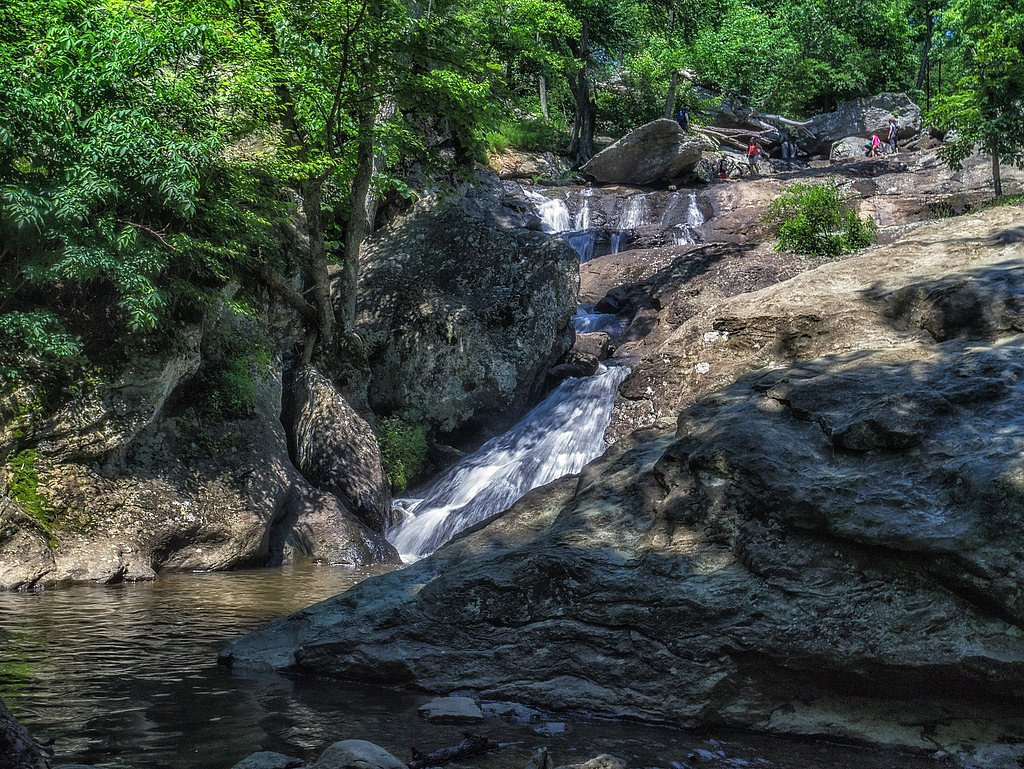
About The Cascade
The Cascade tumbles through a shaded gorge in Patapsco Valley State Park, offering a sequence of small, photogenic drops over moss-covered rocks and ledges. Nestled within the state park managed by the Maryland Department of Natural Resources, the falls are framed by mature hardwood forest and make a refreshing stop on a longer Patapsco Valley outing — popular with hikers, photographers, and families looking for an easy nature escape. Access to The Cascade is straightforward: a short hike brings you to the rock-strewn pools and stepped cascades where you can linger on exposed ledges to enjoy the sound of falling water. The setting feels intimate rather than remote, making it a great half-day destination from nearby trailheads and park facilities.
The Setting
The Cascade sits at 968 feet along the Catoctin Creek, in the foothills of Maryland.
Nearby Falls Worth Visiting
Cunningham Falls, the tallest waterfall in Maryland at 78 feet, lies 8.4 miles to the northeast.
Trail & Hike Details
The Approach
The easy 2.2-mile out-and-back trail gains 200 feet of elevation on the way to the falls.
Trail Description
Cascade Falls Trail (out-and-back, 2.2 miles round trip) is rated easy with roughly 200 feet of elevation gain. The path is generally well-maintained natural surface with some rocky sections and short, gentle inclines — suitable for most visitors including families. Expect a modest grade and an easy-to-follow route that leads directly to the cascade; while not a technical climb, parts of the approach can be uneven underfoot, so sturdy shoes are recommended.
What to Expect
Dogs are welcome.
Accessibility
The trail is not wheelchair accessible. Uneven terrain and elevation changes require steady footing.
Frequently Asked Questions
🐶 Are Dogs Allowed at The Cascade?
✅ Dogs are allowed
Are There Any Fees or Permits Required?
🤑 Fee: $3.00
🏊 Is There Swimming at The Cascade?
❌ Swimming is not allowed
When to Visit
Spring and early summer are the best times to visit, as the waterfall tends to have the most water flow during these seasons.
Seasonal Access
The best time to visit is Spring, Summer, and Fall. Winter access may be limited.
Safety Information
Exercise caution on wet or slippery rocks near the waterfall. Stay on marked trails to avoid getting lost or damaging the environment.
Current Water Conditions
18 ft³/s
Current discharge — how much water is flowing
About average for this time of year
Based on 78 years of record
1.68 ft
Water depth at gauge
7-Day Discharge Trend
What does this mean for your visit?
Flow is about average for this time of year.
About This Gauge
This gauge is on a nearby waterway and may not reflect exact conditions at the falls.
7-Day Flow Outlook
Based on the USGS gauge CATOCTIN CREEK NEAR MIDDLETOWN, MD (10 km away).
Today
Barely Flowing
18 cfs
4/10Tomorrow
Barely Flowing
17 cfs
5/10Tue
Barely Flowing
17 cfs
5/10Wed
Barely Flowing
17 cfs
5/10Thu
Barely Flowing
16 cfs
5/10Fri
Barely Flowing
16 cfs
5/10Sat
Low
16 cfs
3/10Best window: Tomorrow — barely flowing flow, sunny (trip score 5/10).
Best time of year: this gauge typically runs highest from mid February to late April, peaking in March.
How we calculate this
This is a transparent outlook, not a precise forecast. We take the waterfall's current flow strength (how it ranks against its historical normal for today, from the nearest USGS stream gauge), carry that ranking forward along the gauge's seasonal curve, and nudge it for forecast rain. Confidence is highest for the next day or two and falls further out. Always check official conditions and your own judgment before visiting — high flows can be dangerous.
Know when to go.
Get a free email alert when waterfalls near Myersville hit peak flow. We only send when conditions are worth the trip — no weekly newsletters, no spam.
Weather Forecast
Location & Access
Getting There
The Cascade is located within the Orange Grove area of Patapsco Valley State Park. Visitors can access the trailhead from the park's main entrance near Catonsville, Maryland. Follow signs for the Cascade Falls Trail.
Get Directions on Google MapsParking
Parking is available at the Orange Grove parking lot within Patapsco Valley State Park. Parking may fill up quickly on weekends and holidays.
Elevation
968 feet above sea level
Coordinates
39.517443° N, -77.524786° W
Visitor Tips & Gear
Arrive early to secure parking, especially on weekends. Wear sturdy shoes as the trail may have rocky or muddy sections. Bring water and snacks, and consider visiting during the spring or after rainfall for the best water flow.
As an Amazon Associate, we earn from qualifying purchases.
This easy 2.2 miles hike is straightforward — comfortable trail shoes and plenty of water should do. Sun exposure on the trail makes good sun protection a must in summer.

Columbia Watertight II Rain Jacket
Packs into its own pocket, seam-sealed, and keeps you dry from spray and surprise rain.

Earth Pak Waterproof Dry Bag
Keeps your phone and gear dry when waterfall mist soaks everything else.

Waterproof Phone Pouch (AiRunTech)
Cheap insurance — take photos right next to the falls without killing your phone.

Polarized Sunglasses (Knockaround)
Cuts glare off the water so you actually see the falls — and your photos turn out better too.

Osprey Daylite Daypack
Light, organized, and just the right size for a day hike — fits water, snacks, and layers.

OR Sombriolet Sun Hat
UPF 50+ sun protection with vents so your head doesn't cook on exposed trail sections.
Where to Stay

SpringHill Suites By Marriott Frederick

Country Inn & Suites by Radisson, Frederick, MD

Best Western Historic Frederick

Holiday Inn Express & Suites Brunswick-Harpers Ferry Area by IHG
Browse vacation cabins and private rentals nearby
Unique outdoor stays — tents, yurts, and treehouses
Rent a campervan or RV for your waterfall road trip
Some links are affiliate links. We may earn a commission at no extra cost to you.
Nearby Campground
Adirondack Shelters
9 miles away · 2 sites
Overview The Adirondack Shelters, located near the northern most point of Catoctin Mountain Park, provide a destination for true nature immersion and an alternative to drive-up camping. A moderate three-mile uphill hike over rocky but generally gently rolling terrain leads to the three-sided shelters similar to those found on the Appalachian Trail. Please plan to pack out everything you bring to the site. At Catoctin Mountain Park, the beauty and solitude of nearly 6,000 acres (2428 ha) of mature
Book on Recreation.govNearby Hot Springs
Hot springs near Myersville, Maryland

Swan Pond Spring
Swan Pond Spring emerges at 72°F from a low-elevation site at just 460 feet in Jefferson County, West Virginia. Located 66.9 me...

Berkeley Springs
Berkeley Springs flows at 72 degrees Fahrenheit in the historic spa town of the same name in Morgan County, West Virginia, repr...
Looking for a soak after your hike? Explore more hot springs near Myersville, Maryland on SoakingSprings.
Explore Maryland springsAdditional Information
Nearby Attractions
Other attractions in Patapsco Valley State Park include the Swinging Bridge, the Grist Mill Trail, and the Avalon area.
Wildlife
Visitors may encounter deer, squirrels, and a variety of bird species along the trail.
Cities near The Cascade
Nearby Waterfalls
Other waterfalls named The Cascade
1 other waterfall shares this name across the U.S.
Writing about The Cascade? Embed this waterfall on your site for free.