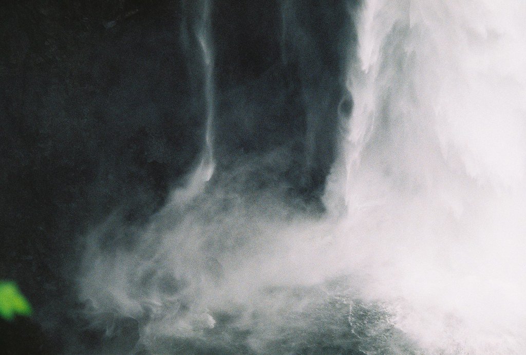
Teepee Falls
By Armen Suny · Last verified May 2026
Difficulty
Moderate
Trail Length
2.4 miles
Trail Type
Out And Back
Elevation Gain
350 ft
About Teepee Falls
Teepee Falls is a tucked-away cascade set amid dense, forested slopes in a Washington State Department of Natural Resources State Resource Management Area, managed by the SDNR. The waterfall drops into a small plunge pool beneath a leafy canopy, giving the site a quiet, secluded feel that makes it a favorite for hikers looking to escape the busier recreation spots. The falls are reached via a moderately rated out-and-back route: the round trip is 2.4 miles with roughly 350 feet of elevation gain. The established forest path leads to a clear viewing area where you can enjoy the cascade and photograph the pool below—plan for a short, worthwhile hike and respect posted SRMA guidelines while visiting.
The Setting
Teepee Falls sits at 801 feet within Washington State Department of Natural Resources (WADNR) State Resource Management Area, fed by the Sauk River, in the foothills of Washington.
Trail & Hike Details
The Approach
The moderate 2.4-mile out-and-back trail gains 350 feet of elevation on the way to the falls.
Trail Description
Trail type: out-and-back; length: 2.4 miles round trip; elevation gain: ~350 feet; difficulty: moderate. The route follows an established forest path through dense timber within WADNR-managed SRMA land and terminates at a viewing area above the falls and its small plunge pool. (No USFS trail number or additional surface/grade/class data provided in the available information.)
What to Expect
Dogs are welcome.
Accessibility
The trail is not wheelchair accessible. Uneven terrain and elevation changes require steady footing.
Frequently Asked Questions
🐶 Are Dogs Allowed at Teepee Falls?
✅ Dogs are allowed
Are There Any Fees or Permits Required?
🤑 Fee: $0.00
🏊 Is There Swimming at Teepee Falls?
❌ Swimming is not allowed
When to Visit
Spring and early summer are the best times to visit, as the waterfall is typically at its fullest due to snowmelt and rainfall.
Seasonal Access
The best time to visit is Spring, Summer, and Fall. Winter access may be limited.
Safety Information
Be cautious of slippery rocks near the waterfall. Check weather conditions before visiting, as heavy rain can make the trail muddy and more challenging. Carry a map or GPS device as cell service may be unreliable.
Current Water Conditions
3,820 ft³/s
Current discharge — how much water is flowing
Much lower than usual for this time of year
Based on 97 years of record
4.67 ft
Water depth at gauge
55°F
ColdBracing — limit time in water
7-Day Discharge Trend
What does this mean for your visit?
Flow is well below normal for this time of year, so the waterfall may be a trickle. Water temperature is a bracing 55 degrees F, limit your time in the water.
About This Gauge
This gauge is on a nearby waterway and may not reflect exact conditions at the falls.
7-Day Flow Outlook
Based on the USGS gauge SAUK RIVER NEAR SAUK, WA (13 km away).
Today
Moderate
4126 cfs
6/10Tomorrow
Moderate
4540 cfs
6/10Sat
Moderate
3999 cfs
6/10Sun
Moderate
4029 cfs
6/10Mon
Moderate
3859 cfs
6/10Tue
Moderate
3737 cfs
6/10Wed
Moderate
3743 cfs
6/10Best window: Today — moderate flow, slight chance light rain (trip score 6/10).
Best time of year: this gauge typically runs highest from late April to late July, peaking in June.
How we calculate this
This is a transparent outlook, not a precise forecast. We take the waterfall's current flow strength (how it ranks against its historical normal for today, from the nearest USGS stream gauge), carry that ranking forward along the gauge's seasonal curve, and nudge it for forecast rain. Confidence is highest for the next day or two and falls further out. Always check official conditions and your own judgment before visiting — high flows can be dangerous.
Know when to go.
Get a free email alert when waterfalls near Marblemount hit peak flow. We only send when conditions are worth the trip — no weekly newsletters, no spam.
Weather Forecast
Location & Access
Getting There
Teepee Falls is located in the Colville National Forest in northeastern Washington. Access typically involves driving on forest service roads, which may be unpaved and require a high-clearance vehicle during certain seasons.
Get Directions on Google MapsParking
Parking is available near the trailhead, but spaces may be limited. Visitors should plan to arrive early, especially during weekends or peak seasons.
Elevation
801 feet above sea level
Coordinates
48.343725° N, -121.440677° W
Land Management
Managed by SDNR
Visitor Tips & Gear
Wear sturdy shoes as the trail may be muddy, especially after rain. Bring insect repellent during the summer months. Cell service may be limited, so download maps or directions in advance.
As an Amazon Associate, we earn from qualifying purchases.
With 2.4 miles and 350 ft of elevation gain, sturdy boots and trekking poles will help on this moderate trail. Sun exposure on the trail makes good sun protection a must in summer.

Columbia Watertight II Rain Jacket
Packs into its own pocket, seam-sealed, and keeps you dry from spray and surprise rain.

Earth Pak Waterproof Dry Bag
Keeps your phone and gear dry when waterfall mist soaks everything else.

Waterproof Phone Pouch (AiRunTech)
Cheap insurance — take photos right next to the falls without killing your phone.

Timberland Euro Sprint Mid Waterproof
Trusted waterproof boot with premium leather and grippy rubber sole — reliable on rocky, wet trails.

TrailBuddy Trekking Poles
Lightweight aluminum, cork grips, and flip-locks that actually hold — a best-seller for good reason.

Polarized Sunglasses (Knockaround)
Cuts glare off the water so you actually see the falls — and your photos turn out better too.
Where to Stay

Glacier Peak Resort and RV Park

PNW River Cabin

New Sauk River Retreat Concrete Wa

Cozy Darrington Cottage w/ Grill, Near Trails
Browse vacation cabins and private rentals nearby
Unique outdoor stays — tents, yurts, and treehouses
Rent a campervan or RV for your waterfall road trip
Some links are affiliate links. We may earn a commission at no extra cost to you.
Nearby Campground
BUCK CREEK CAMPGROUND
7.3 miles away · 29 sites
Overview Situated on the banks of Buck Creek in Mt. Baker-Snoqualmie National Forest, Buck Creek campground offers stunning scenery and access to numerous recreational activities popular in the Northern Cascade Range in Washington. Scattered beneath a towering canopy of old-growth forest, the sites in this campground are secluded and within walking distance to the waterfront, making it an ideal setting for visitors wanting to camp in a private, rustic setting.Recreation Situated along Buck Creek
Book on Recreation.govNearby Hot Springs
Hot springs near Marblemount, Washington
Sulphur Creek Hot Springs
Sulphur Creek Hot Springs flows at 99 degrees Fahrenheit at 2,973 feet elevation in Mount Baker National Forest's remote backco...
Kennedy Hot Spring
Kennedy Hot Spring flows at 100 degrees at 3,520 feet elevation in the Mt. Baker National Forest, emerging 58.7 degrees above a...
Gamma Hot Springs
Gamma Hot Springs produces 140-degree water at 5,397 feet elevation in the Mt. Baker National Forest, emerging 104.6 degrees ab...
Garland Mineral Springs
Garland Mineral Springs flows at 84 degrees in the Snoqualmie National Forest, producing water 39.6 degrees above ambient tempe...
Baker Hot Spring
Baker Hot Spring emerges at 108 degrees Fahrenheit on US Forest Service land in Mt. Baker National Forest, flowing 59.5 degrees...

Sherman Crater Fumaroles
Sherman Crater Fumaroles register 266 degrees Fahrenheit at 9,463 feet elevation within the active volcanic crater atop Mount B...
Looking for a soak after your hike? Explore more hot springs near Marblemount, Washington on SoakingSprings.
Explore Washington springsAdditional Information
Nearby Attractions
Other attractions in the Colville National Forest include Sherman Pass Scenic Byway and Sullivan Lake.
Wildlife
The area is home to a variety of wildlife, including deer, birds, and occasionally black bears. Visitors should practice caution and store food securely.
Cities near Teepee Falls
Nearby Waterfalls
Writing about Teepee Falls? Embed this waterfall on your site for free.