Photo Credits (1)
Difficulty
Moderate
Trail Length
2.4 miles
Trail Type
Out And Back
Elevation Gain
350 ft
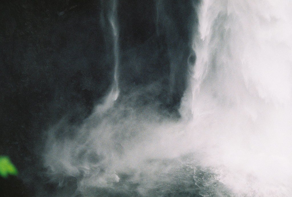
About Gibson Falls
Gibson Falls tumbles into a fern-lined canyon within the Mt. Baker National Forest, offering a peaceful, less-crowded waterfall experience. The approach follows the U.S. Forest Service Huckleberry Mountain Trail (Trail #780) and winds through classic Cascade forest on native tread; because the site is managed by the USFS, signage and the trail corridor are maintained to Forest Service standards. The hike is commonly done as an out-and-back and rewards visitors with a quiet, photogenic cascade framed by old-growth trees. The route is moderately rated and features some steeper pitches, so hikers should arrive prepared for uneven, native-surface footing. If you’re camping, the Suiattle Guard Station campground sits about 1.26 km from the falls, making Gibson Falls an easy addition to an overnight trip. Bring sturdy shoes and expect a tranquil forest setting rather than a heavily developed viewpoint.
The Setting
Gibson Falls sits at 1,171 feet within Mt. Baker National Forest, fed by the Downey Creek, in the foothills of Washington.
Trail & Hike Details
The Approach
The moderate hike follows Huckleberry Mtn (#780), a 2.4-mile out-and-back trail over natural surface. Expect 350 feet of elevation gain with grades of 12-20%. The trail is developed (Class 3).
USFS Trail
HUCKLEBERRY MTN #780
Trail Class
Developed
Surface
Avg Grade
USFS Segment
0.64 miTrail Description
USFS Trail: HUCKLEBERRY MTN (Trail #780). Trail type: out-and-back; total route length: 2.4 miles; elevation gain: ~350 feet; difficulty: moderate. USFS GIS mapped segment: 0.64 miles. Surface: NAT (native material). Typical grade: 12–20%. Class: 3. The tread is primarily native forest floor with moderate to steep pitches and short sections of class-3 terrain—expect uneven footing, roots, and rock; suitable for hikers comfortable with moderate grades and occasional scrambling.
What to Expect
Visitors can expect a peaceful and scenic waterfall surrounded by dense forest. The area may be less crowded compared to more popular waterfalls in Washington.
Accessibility
The trail is not wheelchair accessible. Uneven terrain and elevation changes require steady footing.
Frequently Asked Questions
🐶 Are Dogs Allowed at Gibson Falls?
❌ Dogs are not allowed
Are There Any Fees or Permits Required?
🆖 No fees required
🏊 Is There Swimming at Gibson Falls?
❌ Swimming is not allowed
When to Visit
Spring and early summer are typically the best times to visit, as the waterfall may have higher flow due to snowmelt.
Seasonal Access
The best time to visit is Spring, Summer, and Fall. Winter access may be limited. Check with Mt. Baker National Forest for seasonal road closures.
Safety Information
Visitors should be cautious of slippery rocks, uneven terrain, and changing weather conditions. Cell service may be limited in the area.
Current Water Conditions
96.51 ft
Water depth at gauge
About This Gauge
7-Day Flow Outlook
Based on the USGS gauge DOWNEY CREEK AT MOUTH NEAR DARRINGTON, WA (8 km away).
Today
Low
233 cfs
3/10Tomorrow
Low
270 cfs
4/10Sun
Low
239 cfs
4/10Mon
Low
224 cfs
4/10Tue
Low
235 cfs
4/10Wed
Low
220 cfs
4/10Thu
Low
196 cfs
4/10Best window: Tomorrow — low flow, light rain likely (trip score 4/10).
Best time of year: this gauge typically runs highest from late May to mid July, peaking in May.
How we calculate this
This is a transparent outlook, not a precise forecast. We take the waterfall's current flow strength (how it ranks against its historical normal for today, from the nearest USGS stream gauge), carry that ranking forward along the gauge's seasonal curve, and nudge it for forecast rain. Confidence is highest for the next day or two and falls further out. Always check official conditions and your own judgment before visiting — high flows can be dangerous.
Know when to go.
Get a free email alert when waterfalls near Darrington hit peak flow. We only send when conditions are worth the trip — no weekly newsletters, no spam.
Weather Forecast
Location & Access
Getting There
The exact location and access details for Gibson Falls are not well-documented. Visitors may need to consult local hiking resources or maps for directions.
Get Directions on Google MapsParking
Parking availability is unclear. It is recommended to check with local resources or visitor centers for updated information.
Elevation
1,171 feet above sea level
Coordinates
48.255112° N, -121.332612° W
Land Management
Managed by USFS
Visitor Tips & Gear
Check local conditions and trail reports before visiting. Bring a map or GPS device as the trail may not be well-marked.
As an Amazon Associate, we earn from qualifying purchases.
With 2.4 miles and 350 ft of elevation gain, sturdy boots and trekking poles will help on this moderate trail. Sun exposure on the trail makes good sun protection a must in summer.

Polarized Sunglasses (Knockaround)
Cuts glare off the water so you actually see the falls — and your photos turn out better too.

Columbia Watertight II Rain Jacket
Packs into its own pocket, seam-sealed, and keeps you dry from spray and surprise rain.

Earth Pak Waterproof Dry Bag
Keeps your phone and gear dry when waterfall mist soaks everything else.

Waterproof Phone Pouch (AiRunTech)
Cheap insurance — take photos right next to the falls without killing your phone.

Timberland Euro Sprint Mid Waterproof
Trusted waterproof boot with premium leather and grippy rubber sole — reliable on rocky, wet trails.

TrailBuddy Trekking Poles
Lightweight aluminum, cork grips, and flip-locks that actually hold — a best-seller for good reason.
Where to Stay

Glacier Peak Resort and RV Park

Riverside Retreat on Skagit River

PNW River Cabin

New Sauk River Retreat Concrete Wa
Browse vacation cabins and private rentals nearby
Unique outdoor stays — tents, yurts, and treehouses
Rent a campervan or RV for your waterfall road trip
Some links are affiliate links. We may earn a commission at no extra cost to you.
Nearby Campground
SUIATTLE GUARD STATION
0.8 miles away · 1 sites
Overview Set near the Suiattle River and surrounded by mountain peaks and old-growth forest, the Suiattle Guard Station (pronounced "Sue-attle") is a historic log cabin that was constructed in 1913 by Tommy Thompson, Assistant Ranger of the Suiattle-Finney District, to house a forest guard. Because of budget limitations at that time, the Forest Service often relied upon rangers to construct their own stations. It is a testament to Ranger Thompson’s skill that the cabin survives to this day as one
Book on Recreation.govNearby Hot Springs
Hot springs near Darrington, Washington
Sulphur Creek Hot Springs
Sulphur Creek Hot Springs flows at 99 degrees Fahrenheit at 2,973 feet elevation in Mount Baker National Forest's remote backco...
Kennedy Hot Spring
Kennedy Hot Spring flows at 100 degrees at 3,520 feet elevation in the Mt. Baker National Forest, emerging 58.7 degrees above a...
Gamma Hot Springs
Gamma Hot Springs produces 140-degree water at 5,397 feet elevation in the Mt. Baker National Forest, emerging 104.6 degrees ab...
Garland Mineral Springs
Garland Mineral Springs flows at 84 degrees in the Snoqualmie National Forest, producing water 39.6 degrees above ambient tempe...
Scenic Hot Springs
Scenic Hot Springs delivers genuinely hot water at 122 degrees Fahrenheit at 2,246 feet elevation in the Cascade Mountains near...
Baker Hot Spring
Baker Hot Spring emerges at 108 degrees Fahrenheit on US Forest Service land in Mt. Baker National Forest, flowing 59.5 degrees...
Looking for a soak after your hike? Explore more hot springs near Darrington, Washington on SoakingSprings.
Explore Washington springsAdditional Information
Nearby Attractions
Other waterfalls and hiking trails in the region may be worth exploring.
Wildlife
The area may feature typical Pacific Northwest wildlife such as birds, deer, and small mammals.
Cities near Gibson Falls
Nearby Waterfalls
Writing about Gibson Falls? Embed this waterfall on your site for free.