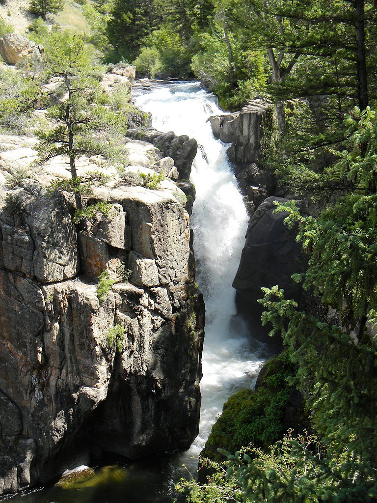
Sweetwater Creek Falls
By Armen Suny · Last verified May 2026
Difficulty
Moderate
Trail Length
2.0 miles
Trail Type
Out And Back
Elevation Gain
300 ft
About Sweetwater Creek Falls
Sweetwater Creek Falls is a secluded cascade tucked into Wyoming’s Shoshone National Forest, managed by the U.S. Forest Service. Nestled in a less-traveled stretch of Sweetwater Creek, the falls offer a quiet, scenic reward for visitors—ideal for photographers, birdwatchers, or anyone looking to escape the crowds and soak in mossy boulder-lined creek scenery. The approach is a short, invigorating outing: roughly a 2.0-mile out-and-back with about 300 feet of elevation gain and a moderate overall difficulty. The route follows the creek through forested terrain with rocky, sometimes rugged sections and may be unmarked in places, so hikers comfortable with uneven footing and basic navigation will get the most from the trip. Spring wildflowers and autumn foliage add seasonal highlights to the journey.
The Setting
Sweetwater Creek Falls sits at 8,337 feet within Shoshone National Forest, fed by the North Fork Shoshone River, in the high alpine of Wyoming.
Trail & Hike Details
The Approach
The moderate 2.0-mile out-and-back trail gains 300 feet of elevation on the way to the falls.
Trail Description
Out-and-back, approximately 2.0 miles round trip with ~300 feet of elevation gain; rated moderate. The trail runs along Sweetwater Creek on U.S. Forest Service land in Shoshone National Forest and features a rugged, sometimes rocky tread with short climbs and uneven footing. Portions of the route may be unmarked, so bring a map or GPS and be prepared for basic route-finding; trail surface is natural/primitive with mixed grade consistent with creekside forest terrain.
What to Expect
Visitors can expect a peaceful hike through a remote area with scenic views of Sweetwater Creek and the surrounding landscape. The falls themselves are a rewarding sight, cascading over rocks into a tranquil pool below.
Accessibility
The trail is not wheelchair accessible. Uneven terrain and elevation changes require steady footing.
Frequently Asked Questions
🐶 Are Dogs Allowed at Sweetwater Creek Falls?
❌ Dogs are not allowed
Are There Any Fees or Permits Required?
🆖 No fees required
🏊 Is There Swimming at Sweetwater Creek Falls?
❌ Swimming is not allowed
When to Visit
Spring and early summer are ideal for visiting, as the falls are typically at their fullest due to snowmelt. Fall offers cooler temperatures and beautiful foliage.
Seasonal Access
The best time to visit is Spring, Summer, and Fall. Access roads and trails may close during winter due to snow. Check with Shoshone National Forest for seasonal road closures.
Safety Information
The trail can be slippery after rain, and the remote location means cell service may be limited. Visitors should inform someone of their plans and carry a first aid kit. Be cautious of wildlife and avoid leaving food unattended.
Current Water Conditions
Based on a USGS gauge 18.1 miles away
2,340 ft³/s
Current discharge — how much water is flowing
About average for this time of year
Based on 36 years of record
5.31 ft
Water depth at gauge
7-Day Discharge Trend
What does this mean for your visit?
Flow is about average for this time of year.
About This Gauge
This gauge is on a regional waterway. Conditions at the falls may differ, especially after local rain.
7-Day Flow Outlook
Based on the USGS gauge NORTH FORK SHOSHONE RIVER AT WAPITI, WY (29 km away).
Today
Low
2668 cfs
3/10Tomorrow
Moderate
2953 cfs
4/10Fri
Moderate
2909 cfs
4/10Sat
Moderate
2676 cfs
4/10Sun
Moderate
2362 cfs
5/10Mon
Low
2380 cfs
4/10Tue
Low
2069 cfs
6/10Best window: Tue — low flow, sunny (trip score 6/10).
Best time of year: this gauge typically runs highest from late April to late July, peaking in June.
How we calculate this
This is a transparent outlook, not a precise forecast. We take the waterfall's current flow strength (how it ranks against its historical normal for today, from the nearest USGS stream gauge), carry that ranking forward along the gauge's seasonal curve, and nudge it for forecast rain. Confidence is highest for the next day or two and falls further out. Always check official conditions and your own judgment before visiting — high flows can be dangerous.
Know when to go.
Get a free email alert when waterfalls near Cooke City hit peak flow. We only send when conditions are worth the trip — no weekly newsletters, no spam.
Weather Forecast
Location & Access
Getting There
Sweetwater Creek Falls is located in a remote area of Wyoming. Access typically involves driving on unpaved roads, and a high-clearance vehicle may be recommended. Exact directions should be verified with local resources or maps.
Get Directions on Google MapsParking
Parking is limited and may be informal, typically along the roadside or at small pullouts near the trailhead.
Elevation
8,337 feet above sea level
Coordinates
44.592148° N, -109.745265° W
Land Management
Managed by USFS
Visitor Tips & Gear
Wear sturdy hiking shoes, as the trail can be rocky and uneven. Bring plenty of water and snacks, as there are no facilities nearby. Check weather conditions before visiting, as the area can become muddy or slippery after rain.
This trail sits at 8,337 ft — the air is noticeably thinner
High AltitudeSome visitors experience headaches, fatigue, or shortness of breath at this elevation. Take it slow, stay hydrated, and consider supplemental oxygen if you're coming from a lower altitude.
As an Amazon Associate, we earn from qualifying purchases.

Coppertone Sport SPF 50 Sunscreen
UV intensity jumps ~4% per 1,000 ft — at this elevation you can burn in half the time.

Sun Bum SPF 30 Lip Balm (3-Pack)
Lips have almost no natural UV protection and burn fast in thin, dry mountain air.

Liquid I.V. Electrolyte Packets
You lose moisture ~2x faster at elevation — electrolytes help you absorb water efficiently.

ROCKNIGHT Polarized UV400 Sunglasses
High-altitude glare off rock and water is intense — UV400 lenses block 99%+ of UVA/UVB.

Boost Oxygen 10L Canister (2-Pack)
Portable supplemental oxygen for quick relief from headaches and shortness of breath.

Altitude Rx OxyBoost Complex
Antioxidant formula designed to support your body's natural altitude acclimation.
As an Amazon Associate, we earn from qualifying purchases.
With 2.0 miles and 300 ft of elevation gain, sturdy boots and trekking poles will help on this moderate trail. Sun exposure on the trail makes good sun protection a must in summer.

Columbia Watertight II Rain Jacket
Packs into its own pocket, seam-sealed, and keeps you dry from spray and surprise rain.

Earth Pak Waterproof Dry Bag
Keeps your phone and gear dry when waterfall mist soaks everything else.

Waterproof Phone Pouch (AiRunTech)
Cheap insurance — take photos right next to the falls without killing your phone.

Timberland Euro Sprint Mid Waterproof
Trusted waterproof boot with premium leather and grippy rubber sole — reliable on rocky, wet trails.

TrailBuddy Trekking Poles
Lightweight aluminum, cork grips, and flip-locks that actually hold — a best-seller for good reason.

Polarized Sunglasses (Knockaround)
Cuts glare off the water so you actually see the falls — and your photos turn out better too.
Where to Stay

Pure Heart Retreat

Yellowstone Valley Inn

Green Creek Inn and RV Park

Trail Shop Inn
Browse vacation cabins and private rentals nearby
Unique outdoor stays — tents, yurts, and treehouses
Rent a campervan or RV for your waterfall road trip
Some links are affiliate links. We may earn a commission at no extra cost to you.
Nearby Campground
REX HALE
9.4 miles away · 29 sites
Overview Rex Hale Campground is located along the Buffalo Bill Scenic Byway about 36 miles west of Cody, in northwestern Wyoming. It is just over 16 miles east of Yellowstone National Park's east entrance. The surrounding area offers many outdoor recreational opportunities, including fishing, hiking and viewing local wildlife. The campground is named after Rex Hale, one of 15 firefighters who died in the 1937 Blackwater Fire, which burned more than 1,700 acres of Forest Service lands within the S
Book on Recreation.govNearby Hot Springs
Hot springs near Cooke City, Wyoming
Hot Springs
Perched at 8,683 feet in Yellowstone's alpine backcountry, this warm spring sits 12.2 miles from Hoodoo Basin Trail, making it ...
Hot Springs
This warm spring emerges at 7,948 feet elevation in Yellowstone's northeastern wilderness, 11.5 miles from Northeast Entrance R...

Unnamed Spring Gallatin County 1
This unnamed thermal feature flows at 95°F in Yellowstone's remote eastern backcountry at 7,895 feet elevation, located over 5....
Hot Springs In Pelican Valley
Hot Springs in Pelican Valley emerges at 156°F at 7,900 feet elevation, discharging thermal water 122 degrees above ambient tem...
The Mushpots
The Mushpots steam at 8,093 feet elevation in Yellowstone's remote eastern backcountry, sitting nearly 11 kilometers from the E...
The Mudkettles
The Mudkettles bubble at 8,028 feet elevation in Yellowstone's eastern backcountry, requiring a trek of more than 10.5 kilomete...
Looking for a soak after your hike? Explore more hot springs near Cooke City, Wyoming on SoakingSprings.
Explore Wyoming springsAdditional Information
Nearby Attractions
The Sweetwater River and surrounding wilderness areas offer additional opportunities for hiking, fishing, and exploring.
Wildlife
The area is home to a variety of wildlife, including deer, birds, and small mammals. Visitors should be aware of the potential presence of bears and take appropriate precautions.
Cities near Sweetwater Creek Falls
Nearby Waterfalls
Writing about Sweetwater Creek Falls? Embed this waterfall on your site for free.