Swans Falls
By Armen Suny · Last verified May 2026
Difficulty
Moderate
Trail Length
2.4 miles
Trail Type
Out And Back
Elevation Gain
350 ft
About Swans Falls
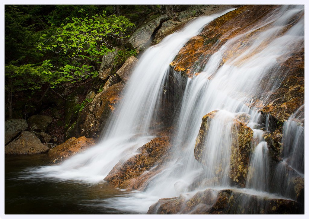
Swans Falls is a small, scenic cascade on the Saco River in Fryeburg, Maine. Rather than a dramatic plunge, the falls spread into a gentle, rocky drop and broad rapids that attract paddlers and visitors looking for a peaceful riverside stop. The surrounding woodlands frame the water with seasonal color, and the mellow sound of moving water makes this a great spot for photos, a picnic, or a short nature break while paddling the Saco.
The Setting
Swans Falls sits at 381 feet along the Saco River, in the coastal lowlands of Maine.
Trail & Hike Details
The Approach
The moderate 2.4-mile out-and-back trail gains 350 feet of elevation on the way to the falls.
Trail Description
Access is via a 2.4-mile out-and-back route with roughly 350 feet of elevation gain and a moderate difficulty rating. The trail follows the river corridor and includes some short, steeper pitches—suitable for hikers comfortable with uneven footing and a moderate grade. There’s no USFS trail number provided here; for current conditions or any campground info, check with the nearby Saco Ranger District (the nearest USFS campground is about 13.7 km away).
What to Expect
Swimming is permitted. Dogs are welcome.
Accessibility
The trail is not wheelchair accessible. Uneven terrain and elevation changes require steady footing.
Frequently Asked Questions
🐶 Are Dogs Allowed at Swans Falls?
✅ Dogs are allowed
Are There Any Fees or Permits Required?
🤑 Fee: $5.00
🏊 Is There Swimming at Swans Falls?
✅ Swimming is allowed
When to Visit
Spring and summer are the best times to visit Swans Falls, as the water levels are typically higher, and the surrounding area is lush and green.
Seasonal Access
The best time to visit is Spring, Summer, and Fall. Winter access may be limited.
Safety Information
Be cautious of slippery rocks near the falls and along the riverbank. Always supervise children and pets near the water. Check water levels and currents before swimming or engaging in water activities.
Current Water Conditions
Based on a USGS gauge 18.8 miles away
4,310 ft³/s
Current discharge — how much water is flowing
Much higher than usual for this time of year
Based on 110 years of record
5.41 ft
Water depth at gauge
7-Day Discharge Trend
What does this mean for your visit?
The water is flowing much higher than usual, expect an impressive display.
About This Gauge
This gauge is on a regional waterway. Conditions at the falls may differ, especially after local rain.
7-Day Flow Outlook
Based on the USGS gauge Saco River at Cornish, Maine (30 km away).
Today
Barely Flowing
4655 cfs
3/10Tomorrow
Barely Flowing
4307 cfs
4/10Sun
Low
4785 cfs
3/10Mon
Barely Flowing
4551 cfs
5/10Tue
Barely Flowing
4594 cfs
3/10Wed
Low
4764 cfs
4/10Thu
Low
4787 cfs
3/10Best window: Mon — barely flowing flow, mostly sunny (trip score 5/10).
Best time of year: this gauge typically runs highest from mid March to early June, peaking in April.
How we calculate this
This is a transparent outlook, not a precise forecast. We take the waterfall's current flow strength (how it ranks against its historical normal for today, from the nearest USGS stream gauge), carry that ranking forward along the gauge's seasonal curve, and nudge it for forecast rain. Confidence is highest for the next day or two and falls further out. Always check official conditions and your own judgment before visiting — high flows can be dangerous.
Know when to go.
Get a free email alert when waterfalls near North Conway hit peak flow. We only send when conditions are worth the trip — no weekly newsletters, no spam.
Weather Forecast
Location & Access
Getting There
Swans Falls is located near Fryeburg, Maine, and can be accessed via Swans Falls Road. The area is managed by the Saco River Recreational Council, and there is a small parking area near the Swans Falls Campground.
Get Directions on Google MapsParking
There is a small parking lot available near the Swans Falls Campground. Parking may be limited during peak seasons.
Elevation
381 feet above sea level
Coordinates
44.038125° N, -70.982569° W
Visitor Tips & Gear
Arrive early during peak seasons to secure parking. Bring bug spray during the summer months, as mosquitoes can be present. If you plan to kayak or canoe, check water levels and conditions beforehand.
As an Amazon Associate, we earn from qualifying purchases.
With 2.4 miles and 350 ft of elevation gain, sturdy boots and trekking poles will help on this moderate trail. Sun exposure on the trail makes good sun protection a must in summer.

Columbia Watertight II Rain Jacket
Packs into its own pocket, seam-sealed, and keeps you dry from spray and surprise rain.

Earth Pak Waterproof Dry Bag
Keeps your phone and gear dry when waterfall mist soaks everything else.

Waterproof Phone Pouch (AiRunTech)
Cheap insurance — take photos right next to the falls without killing your phone.

Timberland Euro Sprint Mid Waterproof
Trusted waterproof boot with premium leather and grippy rubber sole — reliable on rocky, wet trails.

TrailBuddy Trekking Poles
Lightweight aluminum, cork grips, and flip-locks that actually hold — a best-seller for good reason.

Polarized Sunglasses (Knockaround)
Cuts glare off the water so you actually see the falls — and your photos turn out better too.
Where to Stay

Admiral Peary Inn

Comfort Inn & Suites North Conway

Home2 Suites By Hilton North Conway, NH

Cambria Hotel North Conway
Browse vacation cabins and private rentals nearby
Unique outdoor stays — tents, yurts, and treehouses
Rent a campervan or RV for your waterfall road trip
Some links are affiliate links. We may earn a commission at no extra cost to you.
Nearby Campground
Saco Ranger District
8.5 miles away · 0 sites
Located on the south eastern part of the forest, the District offers a variety of different recreational opportunities. Journey across the Kancamagus Scenic Byway; experience the famous Mt Chocorua area; find solitude in the Presidential Range-Dry River or Sandwich Wildernesses; or discover the beauty along Scenic Route 113. Recreational opportunities are endless: hiking, camping, hiking, biking, fishing, skiing (alpine, cross country, and backcountry), snowmobiling, snowshoeing and much more.
Book on Recreation.govAdditional Information
Nearby Attractions
Nearby attractions include the Fryeburg Fairgrounds, Jockey Cap Rock, and other scenic spots along the Saco River.
Wildlife
The area around Swans Falls is home to various bird species, including herons and eagles, as well as small mammals and fish in the river.
Cities near Swans Falls
Nearby Waterfalls
Writing about Swans Falls? Embed this waterfall on your site for free.