Superior Falls
Michigan • 90 ft
By Armen Suny · Last verified Mar 2026
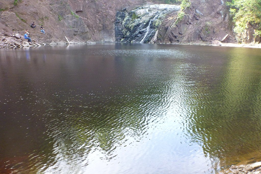
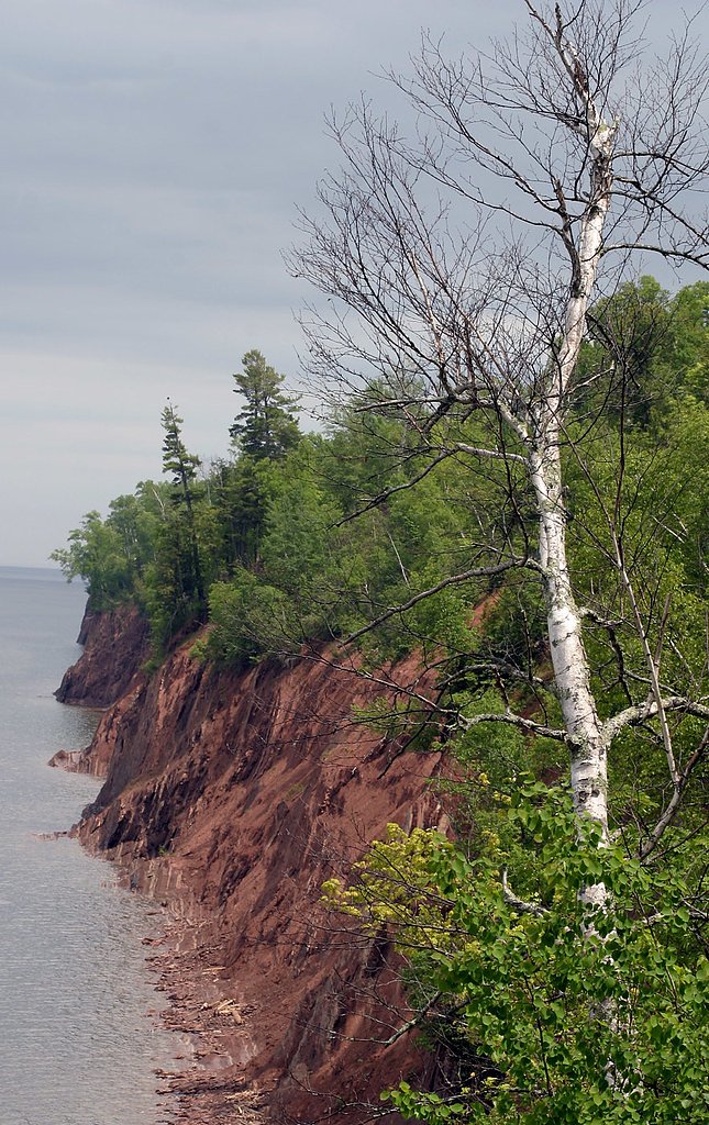
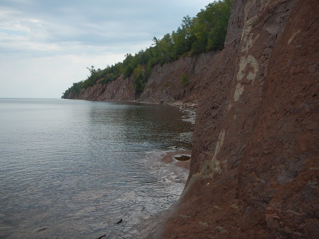
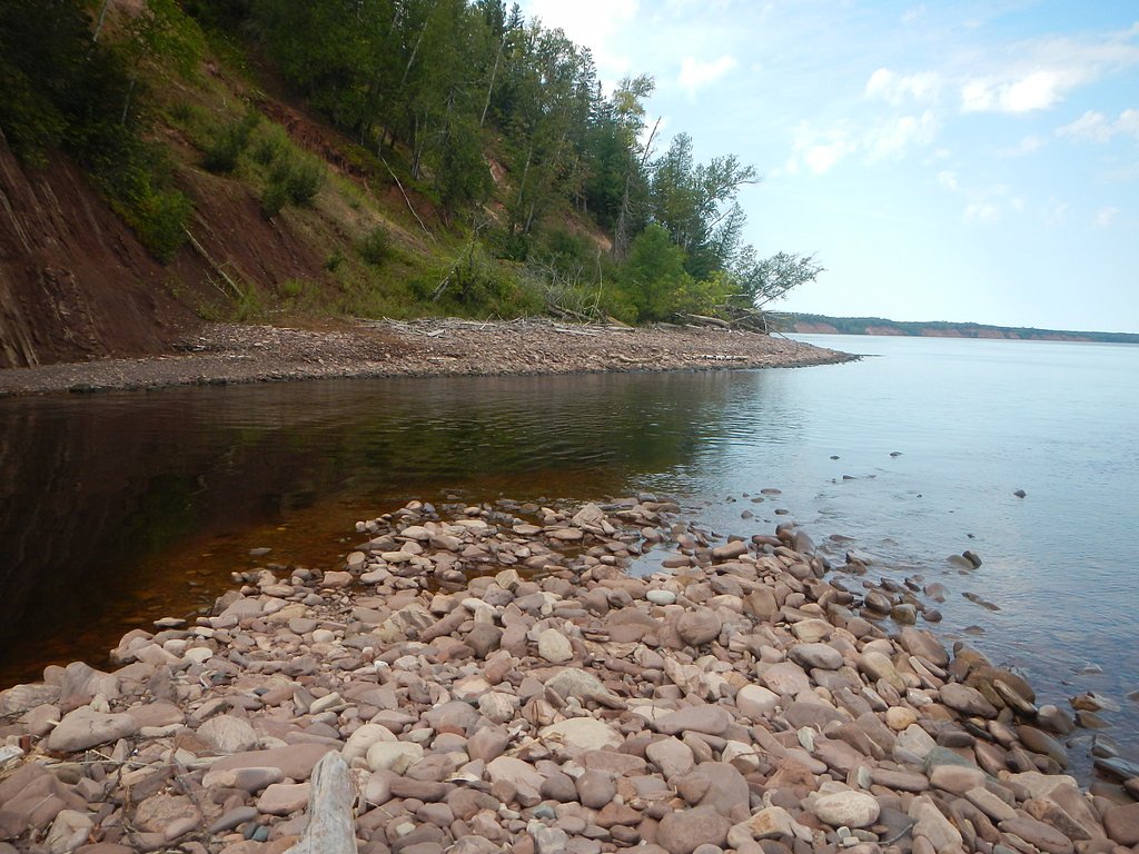
Photo Credits (5)
Difficulty
Moderate
Trail Length
2.4 miles
Trail Type
Out And Back
Elevation Gain
350 ft
About Superior Falls
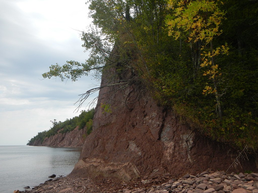
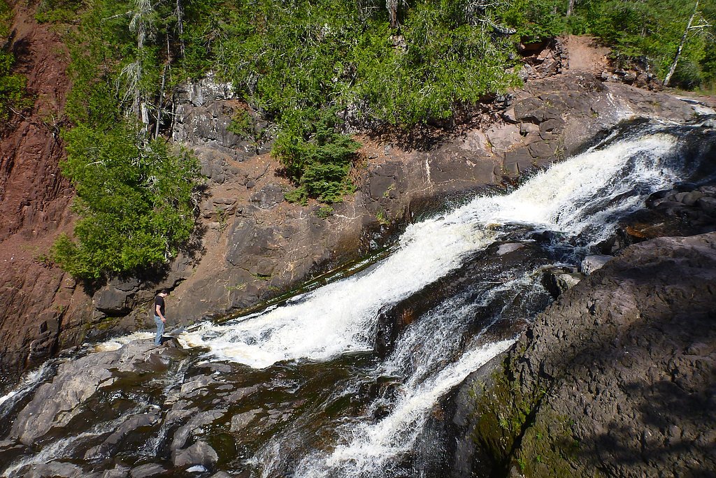
Superior Falls sits on the Montreal River, the waterway that forms the border between Iron County, Wisconsin and Gogebic County, Michigan. The river plunges about 90 feet before emptying into Lake Superior at Oronto Bay, producing a dramatic cascade and a photogenic gorge framed by rugged rock and northern forest. The falls draw day-trippers and photographers for the powerful drop and lakeside backdrop; in spring 2006 extreme kayaker Tao Berman even made headlines by descending the chaotic currents over the falls. The hike to the main overlook is a satisfying, moderate outing: a 2.4-mile out-and-back with roughly 350 feet of elevation gain that threads through mixed hardwoods and conifers before opening onto a viewing area above the gorge. The trail’s endpoint offers a clear vantage of the river as it tumbles into Lake Superior, making this a rewarding half-day trip for hikers prepared for some uphill and uneven terrain. Bring sturdy footwear—sections can be muddy and slippery after rain—and plan on a day visit, as there are no developed campgrounds immediately adjacent.
The Setting
Superior Falls sits at 758 feet along the Black River, in the foothills of Michigan. The falls drop 90 feet.
Height: 90 feet
Nearby Falls Worth Visiting
Potato River Falls (90 ft) lies 8.7 miles to the southwest.
Trail & Hike Details
The Approach
The moderate 2.4-mile out-and-back trail gains 350 feet of elevation on the way to the falls.
Trail Description
Trail length: 2.4 miles (out-and-back). Elevation gain: ~350 feet. Difficulty: Moderate. Trail type: Out-and-back. Waterfall height: 90 feet. The route follows a natural tread through mixed forest with some rock and root exposure; expect uneven footing and short steeper pitches rather than sustained climbs. The trail ends at a dedicated viewing area above the gorge, where you can watch the Montreal River drop into Lake Superior at Oronto Bay. Conditions can be muddy or slippery after rain, so wear sturdy shoes and use caution near the cliff edges.
What to Expect
The falls cascade 90 feet. Dogs are welcome.
Accessibility
The trail is not wheelchair accessible. Uneven terrain and elevation changes require steady footing.
Frequently Asked Questions
🐶 Are Dogs Allowed at Superior Falls?
✅ Dogs are allowed
Are There Any Fees or Permits Required?
🆖 No fees required
🏊 Is There Swimming at Superior Falls?
❌ Swimming is not allowed
When to Visit
The best time to visit is in the spring when water flow is at its peak, or in the fall for beautiful autumn colors.
Seasonal Access
The best time to visit is Spring, Summer, and Fall. Winter access may be limited.
Safety Information
Exercise caution near the falls as the rocks can be slippery. Stay on marked trails and avoid getting too close to the edge. In winter, icy conditions may make the trail hazardous.
Current Water Conditions
Based on a USGS gauge 16.6 miles away
33 ft³/s
Current discharge — how much water is flowing
Lower than usual for this time of year
Based on 53 years of record
2.06 ft
Water depth at gauge
7-Day Discharge Trend
What does this mean for your visit?
Flow is lower than usual for this time of year.
About This Gauge
This gauge is on a regional waterway. Conditions at the falls may differ, especially after local rain.
7-Day Flow Outlook
Based on the USGS gauge BLACK RIVER NEAR BESSEMER, MI (27 km away).
Today
Barely Flowing
33 cfs
5/10Tomorrow
Barely Flowing
35 cfs
3/10Mon
Low
42 cfs
3/10Tue
Low
42 cfs
3/10Wed
Low
43 cfs
3/10Thu
Low
34 cfs
3/10Fri
Low
34 cfs
3/10Best window: Today — barely flowing flow, mostly sunny (trip score 5/10).
Best time of year: this gauge typically runs highest from late March to late May, peaking in April.
How we calculate this
This is a transparent outlook, not a precise forecast. We take the waterfall's current flow strength (how it ranks against its historical normal for today, from the nearest USGS stream gauge), carry that ranking forward along the gauge's seasonal curve, and nudge it for forecast rain. Confidence is highest for the next day or two and falls further out. Always check official conditions and your own judgment before visiting — high flows can be dangerous.
Know when to go.
Get a free email alert when waterfalls near Saxon hit peak flow. We only send when conditions are worth the trip — no weekly newsletters, no spam.
Weather Forecast
Location & Access
Getting There
Superior Falls is located near the town of Ironwood, Michigan. From US-2, take Lake Road north for approximately 15 miles. There is a small parking area near the falls, and a short trail leads to the viewing area.
Get Directions on Google MapsParking
There is a small gravel parking area near the trailhead. Parking is free but may be limited during peak seasons.
Elevation
758 feet above sea level
Coordinates
46.561057° N, -90.416291° W
Visitor Tips & Gear
Visit early in the day to avoid crowds, especially during peak seasons. Bring sturdy shoes as the trail can be uneven or muddy. Bug spray is recommended in the summer months.
As an Amazon Associate, we earn from qualifying purchases.
With 2.4 miles and 350 ft of elevation gain, sturdy boots and trekking poles will help on this moderate trail. Sun exposure on the trail makes good sun protection a must in summer.

Polarized Sunglasses (Knockaround)
Cuts glare off the water so you actually see the falls — and your photos turn out better too.

Columbia Watertight II Rain Jacket
Packs into its own pocket, seam-sealed, and keeps you dry from spray and surprise rain.

Earth Pak Waterproof Dry Bag
Keeps your phone and gear dry when waterfall mist soaks everything else.

Waterproof Phone Pouch (AiRunTech)
Cheap insurance — take photos right next to the falls without killing your phone.

Timberland Euro Sprint Mid Waterproof
Trusted waterproof boot with premium leather and grippy rubber sole — reliable on rocky, wet trails.

TrailBuddy Trekking Poles
Lightweight aluminum, cork grips, and flip-locks that actually hold — a best-seller for good reason.
Where to Stay

North Ironwood Acres - Black River Lodge

AmericInn by Wyndham Ironwood

Days Inn by Wyndham Hurley

Bodin's Resort
Browse vacation cabins and private rentals nearby
Unique outdoor stays — tents, yurts, and treehouses
Rent a campervan or RV for your waterfall road trip
Some links are affiliate links. We may earn a commission at no extra cost to you.
Nearby Campground
BLACK RIVER HARBOR PAVILION
19 miles away · 1 sites
Overview Planning a visit to the Black River Harbor Pavilion? Watch for Alerts at the top of the page for any Alerts regarding this facility. The Black River Harbor Pavilion is located within the Black Harbor Recreation Area on Lake Superior in Michigans Upper Peninsula. The historic stone and wood pavilion was constructed by the Civilian Conservation Corps in the 1930s. Recreation Lake Superior offers great opportunities for boating, fishing, and swimming. The North Country National Scenic Trail
Book on Recreation.govAdditional Information
Nearby Attractions
Lake Superior shoreline, Black River Harbor, and Porcupine Mountains Wilderness State Park.
Wildlife
The area is home to various bird species, deer, and other small wildlife. Be cautious of ticks in the warmer months.
Cities near Superior Falls
Nearby Waterfalls
Writing about Superior Falls? Embed this waterfall on your site for free.