Difficulty
Moderate
Trail Length
2.4 miles
Trail Type
Out And Back
Elevation Gain
350 ft
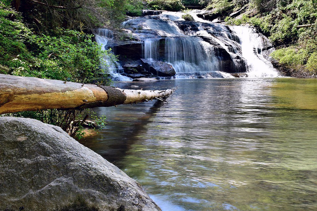
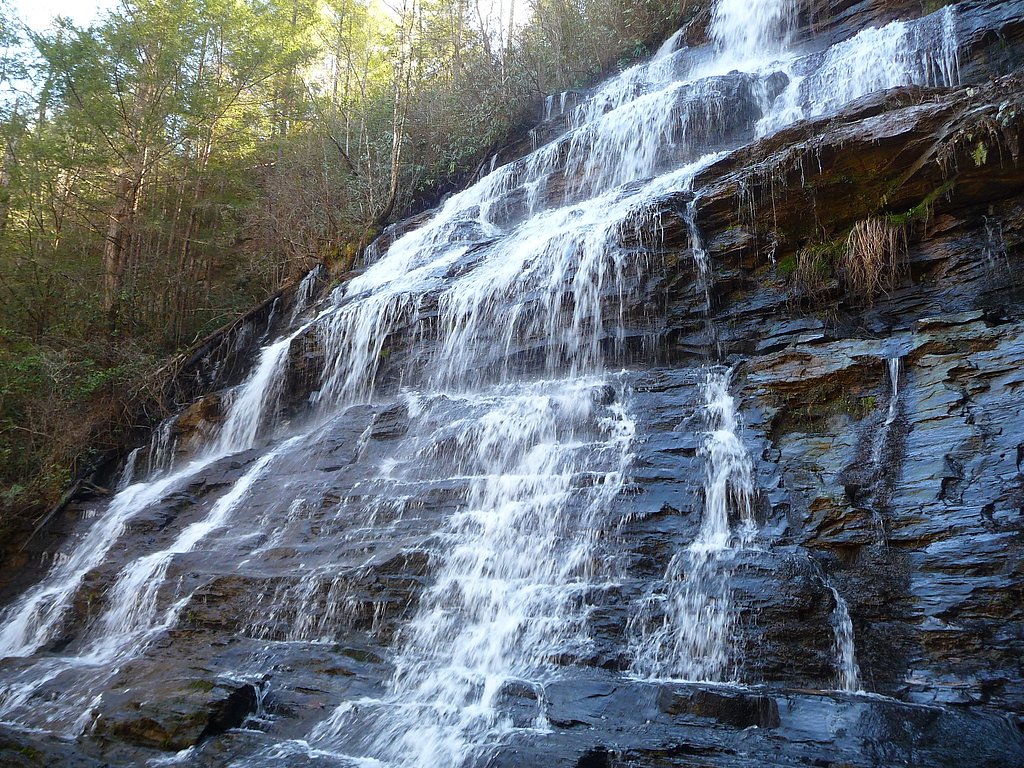
About Stekoa Falls
Stekoa Falls tumbles along Stekoa Creek just outside Clayton in Rabun County, Georgia, offering a peaceful forest setting framed by rhododendron and hardwoods. Rabun County is the northeasternmost county in the state (population 16,883 as of 2020) and is known for its abundant precipitation — averaging more than 70 inches of rain a year — which helps keep Stekoa’s cascades and surrounding greenery lush through much of the year. The falls are compact but scenic, a rewarding stop for hikers and photographers exploring the headwaters and hollows of this rainy corner of Georgia. The site is an easy add-on to a day in the Rabun County mountains; camping is available nearby, with the Chattooga River District campground roughly 9.5 km from the falls for those wanting an overnight stay. Seasonal flows vary with rainfall, so check conditions before heading out, but visitors will typically find the falls accessible and framed by the county’s famously verdant forestlands.
The Setting
Stekoa Falls sits at 1,834 feet along the Tiger Creek, in the hills of Georgia.
Trail & Hike Details
The Approach
The moderate 2.4-mile out-and-back trail gains 350 feet of elevation on the way to the falls.
Trail Description
Trail stats: 2.4 miles round-trip (out-and-back), approximately 350 feet elevation gain, rated moderate. The route follows a wooded path from the trailhead to the base of the falls and is generally straightforward, but the moderate rating reflects the total distance and some short uphill pitches rather than sustained steep climbing. Expect a forest footpath that can be narrow in places and may be slick after heavy rain — Rabun County receives over 70 inches of precipitation annually — so good footwear and caution on wet roots and rocks are advised. Surface type and any USFS trail number/class were not specified in the available data; the trail is typically described as a single woodland path leading to the falls.
What to Expect
Dogs are welcome.
Accessibility
The trail is not wheelchair accessible. Uneven terrain and elevation changes require steady footing.
Frequently Asked Questions
🐶 Are Dogs Allowed at Stekoa Falls?
✅ Dogs are allowed
Are There Any Fees or Permits Required?
🆖 No fees required
🏊 Is There Swimming at Stekoa Falls?
❌ Swimming is not allowed
When to Visit
Spring and early summer are ideal for visiting Stekoa Falls, as the water flow is typically stronger during these seasons.
Seasonal Access
The best time to visit is Spring, Summer, Fall, and Winter.
Safety Information
Exercise caution on the trail, especially after rain, as it may be slippery. Be aware of potential wildlife encounters and avoid venturing too close to the water's edge.
Current Water Conditions
36 ft³/s
Current discharge — how much water is flowing
About average for this time of year
Based on 5 years of record
0.47 ft
Water depth at gauge
7-Day Discharge Trend
What does this mean for your visit?
Flow is about average for this time of year.
About This Gauge
7-Day Flow Outlook
Based on the USGS gauge TIGER CREEK NEAR LAKEMONT, GA (6 km away).
Today
Strong
41 cfs
7/10Tomorrow
Roaring
48 cfs
6/10Tue
Roaring
47 cfs
6/10Wed
Strong
39 cfs
10/10Thu
Moderate
45 cfs
9/10Fri
Strong
43 cfs
7/10Sat
Roaring
43 cfs
6/10Best window: Wed — strong flow, sunny (trip score 10/10).
Best time of year: this gauge typically runs highest from mid February to mid March, peaking in April.
How we calculate this
This is a transparent outlook, not a precise forecast. We take the waterfall's current flow strength (how it ranks against its historical normal for today, from the nearest USGS stream gauge), carry that ranking forward along the gauge's seasonal curve, and nudge it for forecast rain. Confidence is highest for the next day or two and falls further out. Always check official conditions and your own judgment before visiting — high flows can be dangerous.
Know when to go.
Get a free email alert when waterfalls near Tiger hit peak flow. We only send when conditions are worth the trip — no weekly newsletters, no spam.
Weather Forecast
Location & Access
Getting There
Stekoa Falls is located near Clayton, Georgia, and can be accessed via a short drive from the town. The falls are situated near Highway 441, making them relatively easy to locate.
Get Directions on Google MapsParking
There is limited parking available near the falls. Visitors may need to park along the roadside or in nearby designated areas.
Elevation
1,834 feet above sea level
Coordinates
34.838426° N, -83.398495° W
Visitor Tips & Gear
Wear sturdy shoes as the trail may be uneven in places. Visit during the spring or after rainfall for the best water flow. Be mindful of limited parking and plan your visit during off-peak hours if possible.
As an Amazon Associate, we earn from qualifying purchases.
With 2.4 miles and 350 ft of elevation gain, sturdy boots and trekking poles will help on this moderate trail. Icy conditions are common in winter — traction cleats are a smart addition.

Columbia Watertight II Rain Jacket
Packs into its own pocket, seam-sealed, and keeps you dry from spray and surprise rain.

Polarized Sunglasses (Knockaround)
Cuts glare off the water so you actually see the falls — and your photos turn out better too.

Earth Pak Waterproof Dry Bag
Keeps your phone and gear dry when waterfall mist soaks everything else.

Waterproof Phone Pouch (AiRunTech)
Cheap insurance — take photos right next to the falls without killing your phone.

Timberland Euro Sprint Mid Waterproof
Trusted waterproof boot with premium leather and grippy rubber sole — reliable on rocky, wet trails.

TrailBuddy Trekking Poles
Lightweight aluminum, cork grips, and flip-locks that actually hold — a best-seller for good reason.
Where to Stay

Mountain Aire Cottages, Inn & Glamping

Quality Inn & Suites Mt Chalet

Cute n Chic in Clayton

Dahlonega Resort and Vineyard
Browse vacation cabins and private rentals nearby
Unique outdoor stays — tents, yurts, and treehouses
Rent a campervan or RV for your waterfall road trip
Some links are affiliate links. We may earn a commission at no extra cost to you.
Nearby Campground
Chattooga River District
5.9 miles away · 0 sites
The Chattooga River Ranger District covers 261,035 acres in the northeast part of Georgia. Terrain ranges from the Piedmont in the southern part of the district to Georgia's second highest mountain, Rabun Bald at 4,696 feet above sea level. To the east is the Chattooga Wild and Scenic River. In the central part of the district are Lake Burton, Seed Lake, and Lake Rabun where you'll find the Rabun Beach Campground. In the western part of the district are the headwaters of the Chattahoochee River a
Book on Recreation.govAdditional Information
Nearby Attractions
Nearby attractions include Black Rock Mountain State Park and Tallulah Gorge State Park, both offering additional hiking and scenic views.
Wildlife
The area around Stekoa Falls is home to various bird species, small mammals, and native plants. Visitors may spot wildlife along the trail.
Cities near Stekoa Falls
Nearby Waterfalls
Writing about Stekoa Falls? Embed this waterfall on your site for free.