Difficulty
Moderate
Trail Length
2.4 miles
Trail Type
Out And Back
Elevation Gain
350 ft
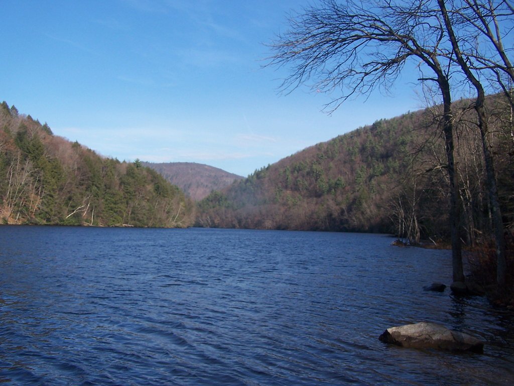
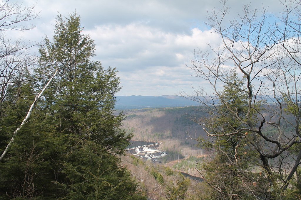
About Spier Falls
Spier Falls is a scenic waterfall on the Hudson River that straddles the line between Saratoga and Warren counties in New York, located east‑southeast of the Village of Corinth. The falls are set among forested riverbanks and framed by the historic Spier Falls Dam, which was constructed to provide hydroelectric electricity. Together the river, timbered slopes, and the dam give the site a mix of natural beauty and industrial history that appeals to photographers and day visitors alike. A short network of hiking routes and river viewpoints puts you close to the falls and the dam, making Spier Falls a rewarding half‑day outing for hikers who enjoy riverside scenery. Trails lead to multiple vantage points along the Hudson, and the setting — wooded stretches punctuated by open river views — makes it an inviting spot for a relaxed hike and casual exploration.
The Setting
Spier Falls sits at 407 feet along the Hudson River, in the coastal lowlands of New York.
Trail & Hike Details
The Approach
The moderate 2.4-mile out-and-back trail gains 350 feet of elevation on the way to the falls.
Trail Description
This is an out-and-back route totaling approximately 2.4 miles round-trip with about 350 feet of elevation gain and is rated moderate. The trail follows forested riverside terrain to viewpoints of the falls and the Spier Falls Dam; specific surface details and an official trail name or number were not provided. The moderate rating reflects the overall climb and distance, so plan for a steady outing appropriate for hikers comfortable with some uphill sections.
What to Expect
Dogs are welcome.
Accessibility
The trail is not wheelchair accessible. Uneven terrain and elevation changes require steady footing.
Frequently Asked Questions
🐶 Are Dogs Allowed at Spier Falls?
✅ Dogs are allowed
Are There Any Fees or Permits Required?
🆖 No fees required
🏊 Is There Swimming at Spier Falls?
❌ Swimming is not allowed
When to Visit
Spring and early summer are the best times to visit, as the waterfall flow is typically stronger due to snowmelt and rainfall.
Seasonal Access
The best time to visit is Spring, Summer, and Fall. Winter access may be limited.
Safety Information
Exercise caution near the water, as currents can be strong. Wear appropriate footwear to avoid slipping on wet or uneven surfaces. Be aware of ticks and other insects in the area.
Current Water Conditions
1,390 ft³/s
Current discharge — how much water is flowing
About average for this time of year
Based on 104 years of record
3.00 ft
Water depth at gauge
7-Day Discharge Trend
What does this mean for your visit?
Flow is about average for this time of year.
About This Gauge
This gauge is on a nearby waterway and may not reflect exact conditions at the falls.
7-Day Flow Outlook
Based on the USGS gauge HUDSON RIVER AT HADLEY NY (12 km away).
Today
Barely Flowing
1390 cfs
5/10Tomorrow
Barely Flowing
1353 cfs
5/10Tue
Low
1585 cfs
3/10Wed
Low
1637 cfs
3/10Thu
Barely Flowing
1329 cfs
5/10Fri
Low
1394 cfs
3/10Sat
Low
1402 cfs
3/10Best window: Today — barely flowing flow, sunny (trip score 5/10).
Best time of year: this gauge typically runs highest from mid March to early June, peaking in April.
How we calculate this
This is a transparent outlook, not a precise forecast. We take the waterfall's current flow strength (how it ranks against its historical normal for today, from the nearest USGS stream gauge), carry that ranking forward along the gauge's seasonal curve, and nudge it for forecast rain. Confidence is highest for the next day or two and falls further out. Always check official conditions and your own judgment before visiting — high flows can be dangerous.
Know when to go.
Get a free email alert when waterfalls near West Glens Falls hit peak flow. We only send when conditions are worth the trip — no weekly newsletters, no spam.
Weather Forecast
Location & Access
Getting There
Spier Falls is located near Moreau Lake State Park in Saratoga County, New York. It can be accessed via Spier Falls Road, which runs along the Hudson River. The area is easily reachable by car.
Get Directions on Google MapsParking
There are parking areas along Spier Falls Road, but availability may vary depending on the season and time of day.
Elevation
407 feet above sea level
Coordinates
43.234795° N, -73.756787° W
Visitor Tips & Gear
Visit during the spring or after heavy rains for the best waterfall flow. Bring sturdy footwear, as some trails may have uneven terrain. Arrive early to secure parking, especially during weekends or peak seasons.
As an Amazon Associate, we earn from qualifying purchases.
With 2.4 miles and 350 ft of elevation gain, sturdy boots and trekking poles will help on this moderate trail. Sun exposure on the trail makes good sun protection a must in summer.

Polarized Sunglasses (Knockaround)
Cuts glare off the water so you actually see the falls — and your photos turn out better too.

Columbia Watertight II Rain Jacket
Packs into its own pocket, seam-sealed, and keeps you dry from spray and surprise rain.

Earth Pak Waterproof Dry Bag
Keeps your phone and gear dry when waterfall mist soaks everything else.

Waterproof Phone Pouch (AiRunTech)
Cheap insurance — take photos right next to the falls without killing your phone.

Timberland Euro Sprint Mid Waterproof
Trusted waterproof boot with premium leather and grippy rubber sole — reliable on rocky, wet trails.

TrailBuddy Trekking Poles
Lightweight aluminum, cork grips, and flip-locks that actually hold — a best-seller for good reason.
Where to Stay

Country Inn & Suites by Radisson, Queensbury - Lake George , NY

Hampton Inn & Suites Saratoga Springs Downtown

The Hotel Saratoga, an Ascend Collection Hotel

Motel Luzerne
Browse vacation cabins and private rentals nearby
Unique outdoor stays — tents, yurts, and treehouses
Rent a campervan or RV for your waterfall road trip
Some links are affiliate links. We may earn a commission at no extra cost to you.
Nearby Hot Springs
Hot springs near West Glens Falls, New York
Looking for a soak after your hike? Explore more hot springs near West Glens Falls, New York on SoakingSprings.
Explore New York springsAdditional Information
Nearby Attractions
Moreau Lake State Park, Hudson River Recreation Area, and the Spier Falls Dam.
Wildlife
The area is home to various bird species, deer, and other small wildlife. Be cautious of ticks during warmer months.
Cities near Spier Falls
Nearby Waterfalls
 CC
CC
Writing about Spier Falls? Embed this waterfall on your site for free.