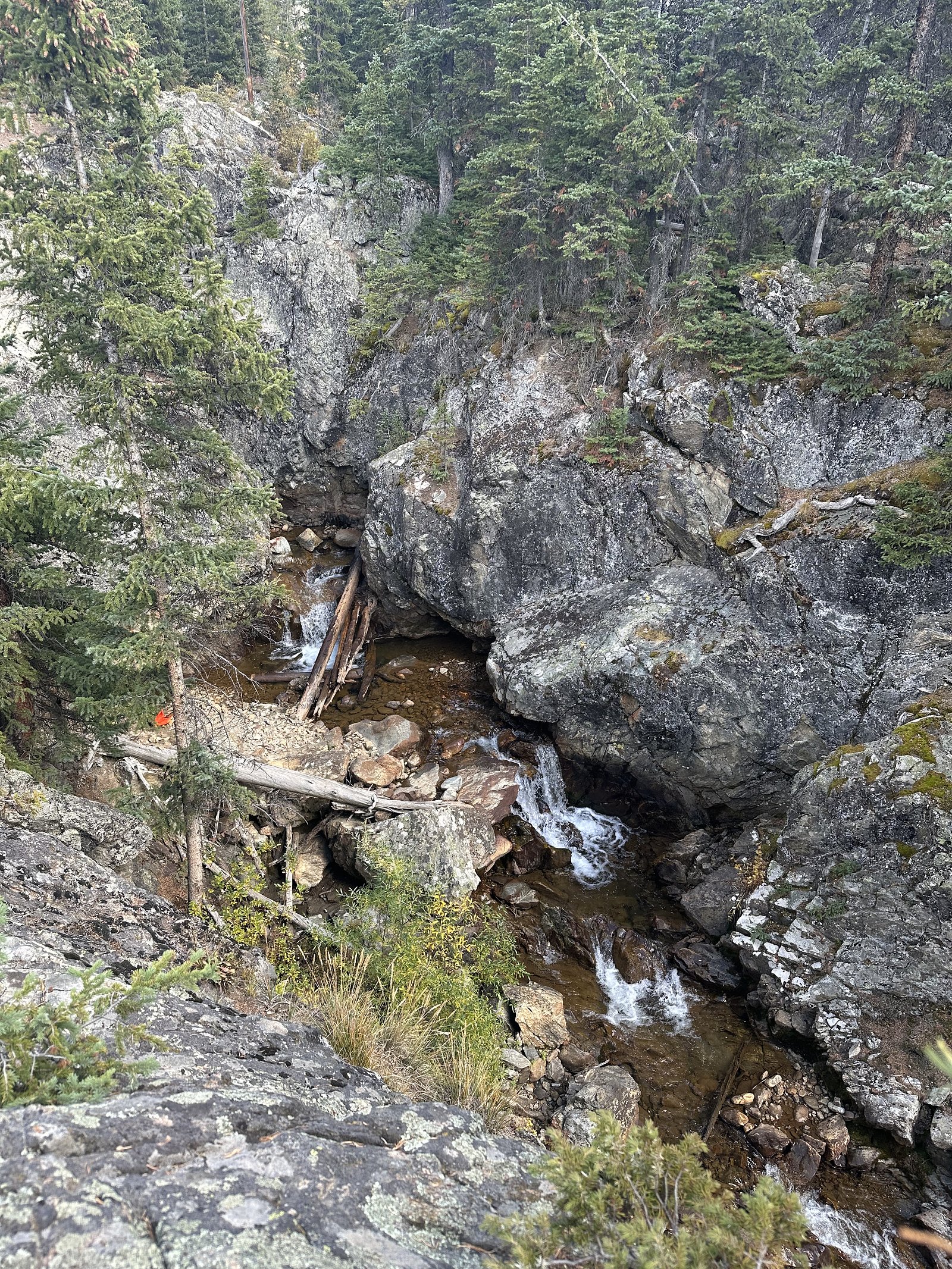
Snake River Falls
By Armen Suny · Last verified May 2026
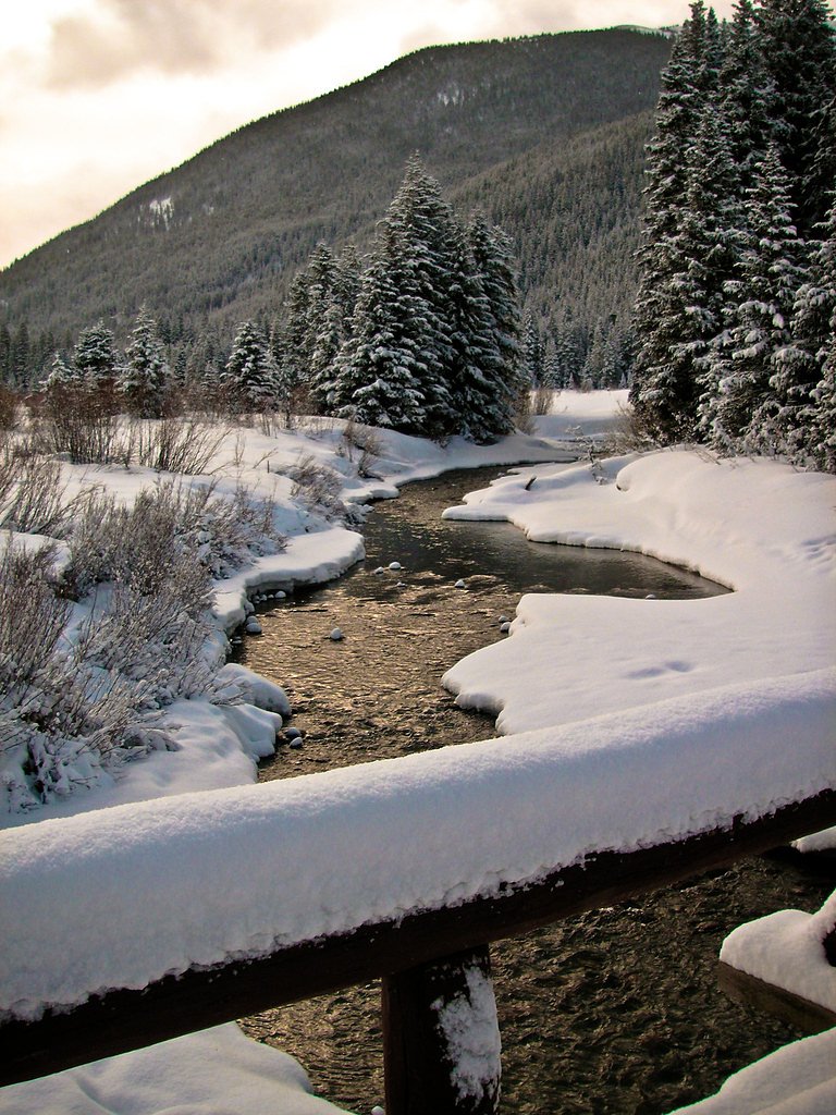

Photo Credits (5)
Difficulty
Moderate
Trail Length
2.0 miles
Trail Type
Out And Back
Elevation Gain
300 ft
About Snake River Falls
Snake River Falls sits along the Snake River in Colorado and offers a compact but rewarding escape into mountain scenery. A short, forested approach brings you to a picturesque cascade framed by evergreens and occasional open views of the surrounding peaks. The setting is popular with day-hikers and nature lovers looking for a relatively quick outing with a strong payoff in scenery. The falls are reached via a moderate out-and-back hike of about 2.0 miles with roughly 300 feet of elevation gain, making it accessible for most hikers who are comfortable with some uphill walking and uneven footing. If you’re planning an extended trip, the nearest designated campground is at Guanella Pass, approximately 14.5 km away, but the falls themselves make an excellent half-day destination for a morning or afternoon outing.
The Setting
Snake River Falls sits at 10,571 feet along the Snake River, in the high alpine of Colorado.
Trail & Hike Details
The Approach
The moderate 2.0-mile out-and-back trail gains 300 feet of elevation on the way to the falls.
Trail Description
Trail type: out-and-back. Distance: 2.0 miles round-trip. Elevation gain: ~300 feet. Difficulty: Moderate. The trail is generally well-marked and winds through a forested corridor with occasional open viewpoints of nearby mountains. Expect some rocky and uneven tread and modest elevation changes — suitable for hikers with basic trail experience. USFS surface/grade/class data for this specific route are not provided in the available dataset.
What to Expect
Dogs are welcome.
Accessibility
The trail is not wheelchair accessible. Uneven terrain and elevation changes require steady footing.
Frequently Asked Questions
🐶 Are Dogs Allowed at Snake River Falls?
✅ Dogs are allowed
Are There Any Fees or Permits Required?
🆖 No fees required
🏊 Is There Swimming at Snake River Falls?
❌ Swimming is not allowed
When to Visit
The best time to visit is during late spring or early summer when water flow is typically at its peak due to snowmelt.
Seasonal Access
The best time to visit is Spring, Summer, and Fall. Access roads and trails may close during winter due to snow.
Safety Information
Hikers should be cautious of slippery rocks near the falls and stay on marked trails. Sudden weather changes are common in the area, so be prepared for rain or temperature drops.
Current Water Conditions
44 ft³/s
Current discharge — how much water is flowing
Much lower than usual for this time of year
Based on 78 years of record
1.45 ft
Water depth at gauge
7-Day Discharge Trend
What does this mean for your visit?
Flow is well below normal for this time of year, so the waterfall may be a trickle.
About This Gauge
7-Day Flow Outlook
Based on the USGS gauge SNAKE RIVER NEAR MONTEZUMA, CO (7 km away).
Today
Barely Flowing
46 cfs
5/10Tomorrow
Barely Flowing
44 cfs
5/10Mon
Barely Flowing
42 cfs
5/10Tue
Barely Flowing
40 cfs
5/10Wed
Barely Flowing
39 cfs
5/10Thu
Barely Flowing
38 cfs
5/10Fri
Barely Flowing
34 cfs
5/10Best window: Today — barely flowing flow, sunny (trip score 5/10).
Best time of year: this gauge typically runs highest from mid May to mid August, peaking in June.
How we calculate this
This is a transparent outlook, not a precise forecast. We take the waterfall's current flow strength (how it ranks against its historical normal for today, from the nearest USGS stream gauge), carry that ranking forward along the gauge's seasonal curve, and nudge it for forecast rain. Confidence is highest for the next day or two and falls further out. Always check official conditions and your own judgment before visiting — high flows can be dangerous.
Know when to go.
Get a free email alert when waterfalls near Montezuma hit peak flow. We only send when conditions are worth the trip — no weekly newsletters, no spam.
Weather Forecast
Location & Access
Getting There
Snake River Falls is located near Keystone, Colorado, within the White River National Forest. Access typically involves driving to a nearby trailhead and hiking to the falls.
Get Directions on Google MapsParking
Parking is available at nearby trailheads, but spaces may be limited during peak seasons. Visitors are advised to arrive early to secure a spot.
Elevation
10,571 feet above sea level
Coordinates
39.640360° N, -105.881694° W
Visitor Tips & Gear
Wear sturdy hiking shoes and bring plenty of water. Arrive early to avoid crowds and secure parking. Check weather conditions before heading out, as trails may become slippery after rain.
This trail sits at 10,571 ft — roughly 30% less oxygen than sea level
Extreme AltitudeAt this elevation, altitude sickness is a real concern. Monitor how you feel, take frequent rest breaks, and descend if symptoms worsen. Visitors arriving from lower elevations should allow time to acclimatize.
As an Amazon Associate, we earn from qualifying purchases.

Coppertone Sport SPF 50 Sunscreen
UV intensity jumps ~4% per 1,000 ft — at this elevation you can burn in half the time.

Sun Bum SPF 30 Lip Balm (3-Pack)
Lips have almost no natural UV protection and burn fast in thin, dry mountain air.

Liquid I.V. Electrolyte Packets
You lose moisture ~2x faster at elevation — electrolytes help you absorb water efficiently.

ROCKNIGHT Polarized UV400 Sunglasses
High-altitude glare off rock and water is intense — UV400 lenses block 99%+ of UVA/UVB.

Boost Oxygen 10L Canister (2-Pack)
Portable supplemental oxygen for quick relief from headaches and shortness of breath.

Altitude Rx OxyBoost Complex
Antioxidant formula designed to support your body's natural altitude acclimation.

Fingertip Pulse Oximeter
Monitor blood oxygen in real time — SpO2 commonly drops to 85–90% above 10,000 ft.
As an Amazon Associate, we earn from qualifying purchases.
With 2.0 miles and 300 ft of elevation gain, sturdy boots and trekking poles will help on this moderate trail. Sun exposure on the trail makes good sun protection a must in summer.

Polarized Sunglasses (Knockaround)
Cuts glare off the water so you actually see the falls — and your photos turn out better too.

Columbia Watertight II Rain Jacket
Packs into its own pocket, seam-sealed, and keeps you dry from spray and surprise rain.

Earth Pak Waterproof Dry Bag
Keeps your phone and gear dry when waterfall mist soaks everything else.

Waterproof Phone Pouch (AiRunTech)
Cheap insurance — take photos right next to the falls without killing your phone.

Timberland Euro Sprint Mid Waterproof
Trusted waterproof boot with premium leather and grippy rubber sole — reliable on rocky, wet trails.

TrailBuddy Trekking Poles
Lightweight aluminum, cork grips, and flip-locks that actually hold — a best-seller for good reason.
Where to Stay

Hyatt Place Keystone - Dillon

Settlers Creek 6522

Buffalo Lodge 8372

River Bank Lodge 2919
Browse vacation cabins and private rentals nearby
Unique outdoor stays — tents, yurts, and treehouses
Rent a campervan or RV for your waterfall road trip
Some links are affiliate links. We may earn a commission at no extra cost to you.
Nearby Campground
GUANELLA PASS
9 miles away · 18 sites
Overview Guanella Pass Campground is located about 7 miles south of Georgetown on the South Fork of Clear Creek on the Guanella Pass Scenic Byway. Located at an elevation of 10,900 feet on the Arapaho Roosevelt National Forest, visitors to the campground can also enjoy hiking and fishing in the area. The Guanella Pass Scenic and Historic Byway follows an old wagon route that linked the mining towns of Georgetown and Grant, Colorado.Recreation Visitors can go trout fishing on the South Fork of Cle
Book on Recreation.govNearby Hot Springs
Hot springs near Montezuma, Colorado

Idaho Springs
Idaho Springs surfaces at 115°F in Clear Creek County at 7,682 feet elevation, emerging near Soda Creek Road just 273 feet from...
Rhodes Warm Spring
Rhodes Warm Spring emerges at 75°F at 10,172 feet elevation in the high mountain country of Park County near Fairplay, offering...

Hot Sulphur Springs
Hot Sulphur Springs flows at 111°F along Parshall Divide Road in Grand County, emerging just 58 feet from the pavement in the s...

Hartsel Hot Springs
Hartsel Hot Springs emerges at 126 degrees Fahrenheit at 8,954 feet elevation in Park County's South Park basin—one of Colorado...

Eldorado Springs
Eldorado Springs emerges at 79 degrees Fahrenheit in Boulder County's foothills as a low-mineralization thermal seep just 9 met...

Radium Hot Springs
Radium Hot Springs emerges on Bureau of Land Management property in the Upper Colorado River Special Recreation Management Area...
Looking for a soak after your hike? Explore more hot springs near Montezuma, Colorado on SoakingSprings.
Explore Colorado springsAdditional Information
Nearby Attractions
Nearby attractions include Keystone Resort, Dillon Reservoir, and the Arapaho National Forest.
Wildlife
The area is home to various wildlife, including deer, elk, and a variety of bird species. Visitors should be cautious of bears and other potentially dangerous animals.
Cities near Snake River Falls
Other waterfalls named Snake River Falls
1 other waterfall shares this name across the U.S.
Writing about Snake River Falls? Embed this waterfall on your site for free.