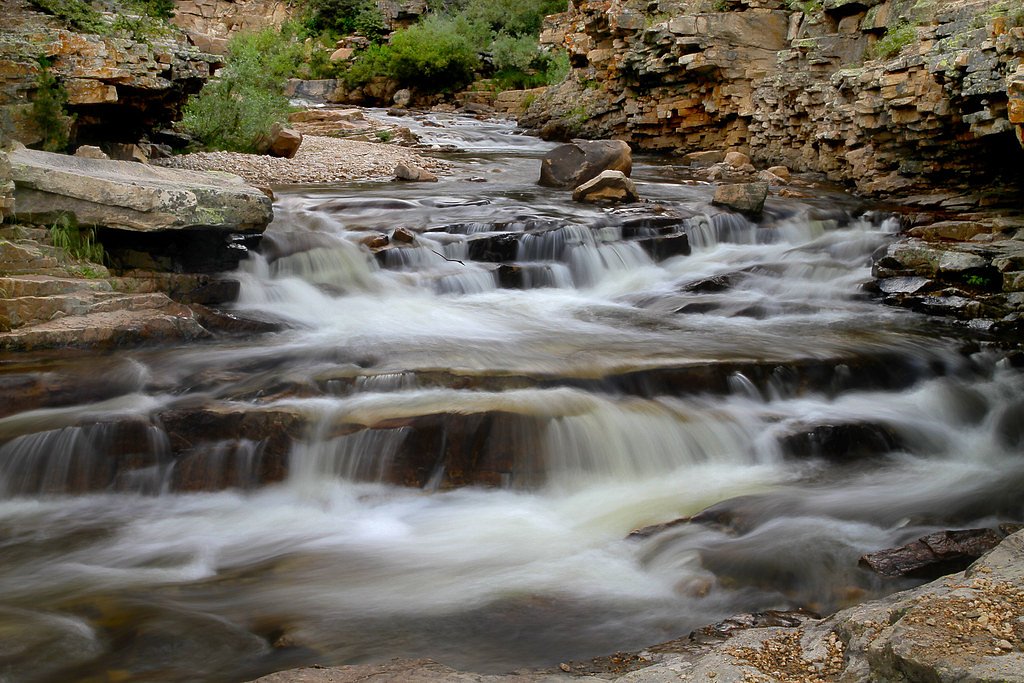
Smooth Rock Falls
By Armen Suny · Last verified May 2026
Photo Credits (4)
Difficulty
Moderate
Trail Length
2.4 miles
Trail Type
Out And Back
Elevation Gain
350 ft
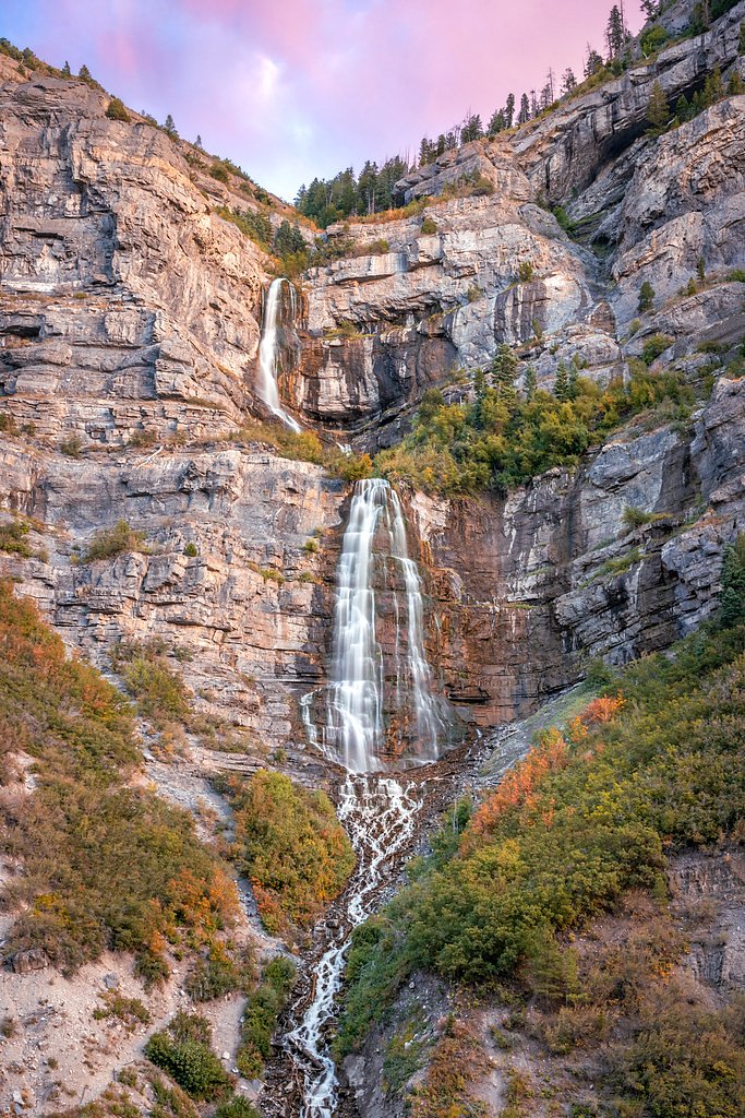
About Smooth Rock Falls
Smooth Rock Falls is a tucked-away cascade managed by the U.S. Forest Service within the Wasatch National Forest. The fall’s intimate setting — carved into rugged canyon terrain and surrounded by forest — makes it a peaceful destination for hikers seeking solitude and scenic photo opportunities. Specific measurements for the waterfall’s height are not well-documented, which adds to its off-the-beaten-path charm. Access is typically via the USFS-listed SPRING CANYON SNOMO MARKED trail (Trail SNO-3096C). The route and trailhead sit within Forest Service lands, and campers will find Soapstone Campground about 5.49 km away if you’re planning an overnight stay. Because the official trail surface is recorded as SNOW, expect wintry or seasonally snowy conditions and plan clothing and gear accordingly.
The Setting
Smooth Rock Falls sits at 8,373 feet within Wasatch National Forest, fed by the Provo River, in the high alpine of Utah.
Trail & Hike Details
The Approach
The moderate hike follows Spring Canyon Snomo Marked (#SNO-3096C), a 2.4-mile out and back trail over snow. Expect 350 feet of elevation gain. The trail is moderately developed (Class 2).
USFS Trail
SPRING CANYON SNOMO MARKED #SNO-3096C
Trail Class
Moderately Developed
Surface
USFS Segment
1.44 miTrail Description
Trail: SPRING CANYON SNOMO MARKED (USFS Trail SNO-3096C) — Class 2, Surface: SNOW. The route is listed with a GIS-measured distance of 1.44 miles and is commonly described as a 2.4-mile out-and-back with roughly 350 feet of elevation gain. Difficulty is rated moderate; the trail type is out-and-back. Note the snow surface designation when picking a travel season and gear, and remember the area is managed by the U.S. Forest Service in Wasatch National Forest.
What to Expect
Visitors can expect a peaceful and scenic environment with natural beauty. The waterfall may be seasonal, depending on water flow conditions.
Accessibility
The trail is not wheelchair accessible. Uneven terrain and elevation changes require steady footing.
Frequently Asked Questions
🐶 Are Dogs Allowed at Smooth Rock Falls?
❌ Dogs are not allowed
Are There Any Fees or Permits Required?
🆖 No fees required
🏊 Is There Swimming at Smooth Rock Falls?
❌ Swimming is not allowed
When to Visit
Spring and early summer are typically the best times to visit, as water flow is likely to be higher due to snowmelt.
Seasonal Access
The best time to visit is Spring, Summer, and Fall. Access roads and trails may close during winter due to snow. Watch for flash flood warnings during monsoon season (July through September). Check with Wasatch National Forest for seasonal road closures.
Safety Information
The trail and waterfall area may have uneven terrain, slippery rocks, and limited signage. Visitors should exercise caution and avoid visiting during inclement weather.
Current Water Conditions
56 ft³/s
Current discharge — how much water is flowing
Much lower than usual for this time of year
Based on 62 years of record
2.58 ft
Water depth at gauge
7-Day Discharge Trend
What does this mean for your visit?
Flow is well below normal for this time of year, so the waterfall may be a trickle.
About This Gauge
This gauge is on a nearby waterway and may not reflect exact conditions at the falls.
7-Day Flow Outlook
Based on the USGS gauge PROVO RIVER NEAR WOODLAND, UT (18 km away).
Today
Moderate
63 cfs
4/10Tomorrow
Moderate
63 cfs
6/10Mon
Moderate
58 cfs
8/10Tue
Moderate
50 cfs
8/10Wed
Moderate
51 cfs
8/10Thu
Moderate
50 cfs
8/10Fri
Moderate
45 cfs
8/10Best window: Mon — moderate flow, mostly sunny (trip score 8/10).
Best time of year: this gauge typically runs highest from mid April to mid July, peaking in June.
How we calculate this
This is a transparent outlook, not a precise forecast. We take the waterfall's current flow strength (how it ranks against its historical normal for today, from the nearest USGS stream gauge), carry that ranking forward along the gauge's seasonal curve, and nudge it for forecast rain. Confidence is highest for the next day or two and falls further out. Always check official conditions and your own judgment before visiting — high flows can be dangerous.
Know when to go.
Get a free email alert when waterfalls near Woodland hit peak flow. We only send when conditions are worth the trip — no weekly newsletters, no spam.
Weather Forecast
Location & Access
Getting There
The exact location and directions to Smooth Rock Falls are not widely documented. Visitors are advised to consult local hiking guides or maps for accurate information.
Get Directions on Google MapsParking
Parking availability is unclear. Visitors should plan ahead and check for nearby parking options or trailhead access.
Hours
Elevation
8,373 feet above sea level
Coordinates
40.600356° N, -110.967629° W
Land Management
Managed by USFS
Visitor Tips & Gear
Bring a detailed map or GPS device, as the location is not well-marked. Wear sturdy footwear and carry sufficient water.
This trail sits at 8,373 ft — the air is noticeably thinner
High AltitudeSome visitors experience headaches, fatigue, or shortness of breath at this elevation. Take it slow, stay hydrated, and consider supplemental oxygen if you're coming from a lower altitude.
As an Amazon Associate, we earn from qualifying purchases.

Coppertone Sport SPF 50 Sunscreen
UV intensity jumps ~4% per 1,000 ft — at this elevation you can burn in half the time.

Sun Bum SPF 30 Lip Balm (3-Pack)
Lips have almost no natural UV protection and burn fast in thin, dry mountain air.

Liquid I.V. Electrolyte Packets
You lose moisture ~2x faster at elevation — electrolytes help you absorb water efficiently.

ROCKNIGHT Polarized UV400 Sunglasses
High-altitude glare off rock and water is intense — UV400 lenses block 99%+ of UVA/UVB.

Boost Oxygen 10L Canister (2-Pack)
Portable supplemental oxygen for quick relief from headaches and shortness of breath.

Altitude Rx OxyBoost Complex
Antioxidant formula designed to support your body's natural altitude acclimation.
As an Amazon Associate, we earn from qualifying purchases.
With 2.4 miles and 350 ft of elevation gain, sturdy boots and trekking poles will help on this moderate trail. Sun exposure on the trail makes good sun protection a must in summer.

Polarized Sunglasses (Knockaround)
Cuts glare off the water so you actually see the falls — and your photos turn out better too.

Columbia Watertight II Rain Jacket
Packs into its own pocket, seam-sealed, and keeps you dry from spray and surprise rain.

Earth Pak Waterproof Dry Bag
Keeps your phone and gear dry when waterfall mist soaks everything else.

Waterproof Phone Pouch (AiRunTech)
Cheap insurance — take photos right next to the falls without killing your phone.

Timberland Euro Sprint Mid Waterproof
Trusted waterproof boot with premium leather and grippy rubber sole — reliable on rocky, wet trails.

TrailBuddy Trekking Poles
Lightweight aluminum, cork grips, and flip-locks that actually hold — a best-seller for good reason.
Where to Stay

Holiday Inn Express Heber City by IHG

Heber Senator Bed and Breakfast

Mountain House PC, Snowy Lake Views Private Hot Tub, New Build, Jordanelle Lake!

Grand Hyatt Deer Valley
Browse vacation cabins and private rentals nearby
Unique outdoor stays — tents, yurts, and treehouses
Rent a campervan or RV for your waterfall road trip
Some links are affiliate links. We may earn a commission at no extra cost to you.
Nearby Campground
SOAPSTONE
3.4 miles away · 37 sites
Overview Soapstone Campground is located on the beautiful Mirror Lake Scenic Byway in the Uinta Mountains of northeastern Utah at an elevation of 8,200 feet. The Uintas are known for their abundant recreational opportunities and scenic beauty.Recreation The Lower Provo River can easily be accessed from the campground and offers good trout fishing. Soapstone Basin is nearby, with miles of exciting off-road vehicle trails for riders of all skill levels. Numerous additional hiking, biking and horseb
Book on Recreation.govNearby Hot Springs
Hot springs near Woodland, Utah
Warm Springs
Emerging at 79 degrees Fahrenheit on the Uintah and Ouray Reservation, this thermal spring rises 36.7 degrees above ambient tem...

Warm Ditch Spring
A 115-degree spring in Wasatch County's Heber Valley, emerging 67.8 degrees above ambient temperature just 64 meters from Jerry...

Midway Hot Springs
Midway Hot Springs flows at 104°F along Mountain Spa Lane, emerging 88 meters from the road at 5,650 feet elevation in the Hebe...

Midway Hot Spring
Midway Hot Spring flows at 115°F in Wasatch County's Heber Valley, running 67.4°F above ambient temperatures at 5,650 feet elev...
Midway Hot Springs
Midway Hot Springs at the Homestead Crater flows at 100°F inside a beehive-shaped limestone dome created by millennia of minera...
Unnamed Spring Summit County
This unnamed 70°F spring flows in Summit County near Snyderville, emerging 27.8 degrees above the 42.2°F ambient temperature at...
Looking for a soak after your hike? Explore more hot springs near Woodland, Utah on SoakingSprings.
Explore Utah springsAdditional Information
Nearby Attractions
Nearby attractions are not well-documented. Visitors may explore other natural landmarks in the region.
Wildlife
The area may host typical Utah wildlife, including birds, deer, and small mammals. Be cautious of potential encounters with snakes or other wildlife.
Cities near Smooth Rock Falls
Nearby Waterfalls
Writing about Smooth Rock Falls? Embed this waterfall on your site for free.