Sandstone Falls
By Armen Suny · Last verified Mar 2026
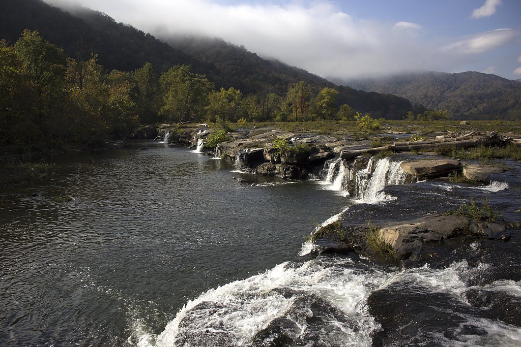
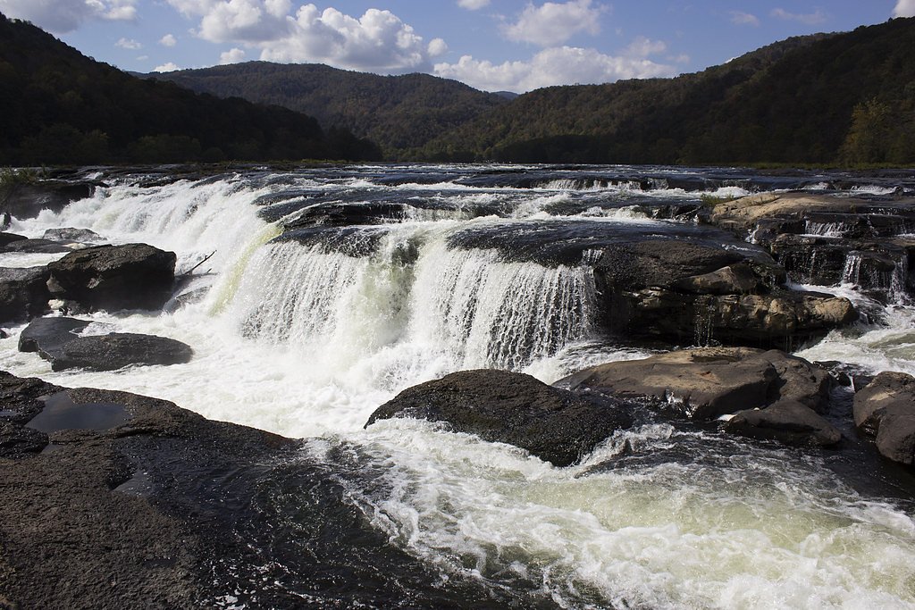
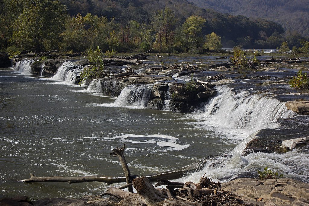
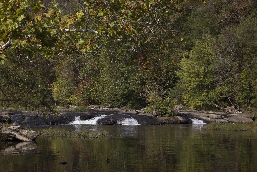

Photo Credits (5)
Difficulty
Moderate
Trail Length
2.4 miles
Trail Type
Out And Back
Elevation Gain
350 ft
About Sandstone Falls
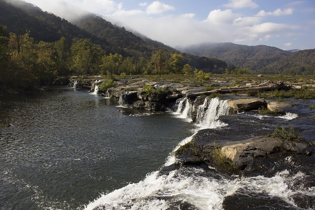
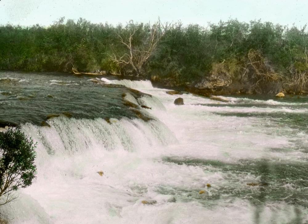
Sandstone Falls is a dramatic, multi-cascade set of rapids and drops on the New River that stretches roughly 1,500 feet across the channel, offering sweeping riverscape views and plenty of photographic angles. The falls’ broad, broken ledges create a series of cataracts rather than a single vertical drop, making the site especially scenic from several vantage points along the shore. The property is privately held and managed by Private Land Owner 1 (designation: PCON; manager listed as PVT), so visitors should be mindful of posted access information and respect the land.
The Setting
Sandstone Falls sits at 1,289 feet within Private Land Owner 1, fed by the New River, in the foothills of West Virginia.
Trail & Hike Details
The Approach
The moderate 2.4-mile out-and-back trail gains 350 feet of elevation on the way to the falls.
Trail Description
Access to Sandstone Falls takes you along an approximately 2.4-mile out-and-back route with about 350 feet of cumulative elevation gain; the hike is rated moderate. The final approach to the river features a well-maintained boardwalk and multiple viewing platforms that provide close, safe views of the cascades, while the approach trail is a mix of natural tread with some moderate grades. There is no USFS trail name or number provided for this route; expect a moderate-grade, unpaved trail leading to the preserved boardwalk viewpoints.
What to Expect
Dogs are welcome.
Accessibility
The trail is not wheelchair accessible. Uneven terrain and elevation changes require steady footing.
Frequently Asked Questions
🐶 Are Dogs Allowed at Sandstone Falls?
✅ Dogs are allowed
Are There Any Fees or Permits Required?
🆖 No fees required
🏊 Is There Swimming at Sandstone Falls?
❌ Swimming is not allowed
When to Visit
The falls are beautiful year-round, but spring and early summer are particularly popular due to higher water flow. Fall offers vibrant foliage, while winter provides a serene, less crowded experience.
Seasonal Access
The best time to visit is Spring, Summer, Fall, and Winter.
Safety Information
Stay on designated paths and viewing platforms to avoid slippery rocks and strong currents. Exercise caution near the water, especially with children.
Current Water Conditions
2,650 ft³/s
Current discharge — how much water is flowing
About average for this time of year
Based on 66 years of record
2.02 ft
Water depth at gauge
77°F
ComfortablePleasant for swimming
7-Day Discharge Trend
What does this mean for your visit?
Flow is about average for this time of year. The water is a comfortable 77 degrees F, pleasant for swimming.
About This Gauge
This gauge is on a nearby waterway and may not reflect exact conditions at the falls.
7-Day Flow Outlook
Based on the USGS gauge NEW RIVER AT HINTON, WV (10 km away).
Today
Moderate
2650 cfs
8/10Tomorrow
Moderate
2467 cfs
6/10Thu
Moderate
2426 cfs
8/10Fri
Moderate
2379 cfs
8/10Sat
Moderate
2774 cfs
6/10Sun
Moderate
2928 cfs
6/10Mon
Moderate
2977 cfs
6/10Best window: Today — moderate flow, mostly sunny (trip score 8/10).
Best time of year: this gauge typically runs highest from mid February to late April, peaking in March.
How we calculate this
This is a transparent outlook, not a precise forecast. We take the waterfall's current flow strength (how it ranks against its historical normal for today, from the nearest USGS stream gauge), carry that ranking forward along the gauge's seasonal curve, and nudge it for forecast rain. Confidence is highest for the next day or two and falls further out. Always check official conditions and your own judgment before visiting — high flows can be dangerous.
Know when to go.
Get a free email alert when waterfalls near Hinton hit peak flow. We only send when conditions are worth the trip — no weekly newsletters, no spam.
Weather Forecast
Location & Access
Getting There
Sandstone Falls is located near Hinton, West Virginia, within the New River Gorge National Park and Preserve. Visitors can access the falls via River Road, which leads to a parking area and boardwalk.
Get Directions on Google MapsParking
There is a designated parking area near the falls, which provides easy access to the boardwalk and viewing platforms.
Elevation
1,289 feet above sea level
Coordinates
37.758452° N, -80.905368° W
Land Management
Managed by PVT
Visitor Tips & Gear
Arrive early during peak seasons to secure parking and enjoy the falls with fewer crowds. Bring a camera to capture the scenic views, and wear comfortable shoes for walking on the boardwalk.
As an Amazon Associate, we earn from qualifying purchases.
With 2.4 miles and 350 ft of elevation gain, sturdy boots and trekking poles will help on this moderate trail. Icy conditions are common in winter — traction cleats are a smart addition.

Columbia Watertight II Rain Jacket
Packs into its own pocket, seam-sealed, and keeps you dry from spray and surprise rain.

Polarized Sunglasses (Knockaround)
Cuts glare off the water so you actually see the falls — and your photos turn out better too.

Earth Pak Waterproof Dry Bag
Keeps your phone and gear dry when waterfall mist soaks everything else.

Waterproof Phone Pouch (AiRunTech)
Cheap insurance — take photos right next to the falls without killing your phone.

Timberland Euro Sprint Mid Waterproof
Trusted waterproof boot with premium leather and grippy rubber sole — reliable on rocky, wet trails.

TrailBuddy Trekking Poles
Lightweight aluminum, cork grips, and flip-locks that actually hold — a best-seller for good reason.
Where to Stay

3 Mi to New River Gorge NP! Rafting and Hiking Hub

Sleep Inn Beaver- Beckley

Tru By Hilton Beckley, Wv

Quality Inn New River Gorge
Browse vacation cabins and private rentals nearby
Unique outdoor stays — tents, yurts, and treehouses
Rent a campervan or RV for your waterfall road trip
Some links are affiliate links. We may earn a commission at no extra cost to you.
Nearby Campground
BLUESTONE LAKE PICNIC SHELTER
8.7 miles away · 1 sites
Overview Bluestone Lake Picnic Shelter is a day-use area near the shores of Bluestone Lake in southern West Virginia. The 2,040 acres of water provide boaters, water skiers and fishermen with plenty of recreational opportunities. With a capacity of up to 100 guests and dozens of activities and amenities, the day use area is a hot spot for large gatherings and outdoor fun. It is very popular among Little League Baseball groups and fishermen.Recreation The New River is the best warm water fishery i
Book on Recreation.govNearby Hot Springs
Hot springs near Hinton, West Virginia
Alum Springs
Alum Springs flows at 72°F in Pulaski County, Virginia, emerging 18.4 degrees above the 53.6°F ambient temperature at 1,967 fee...
Sweet Chalybeate Spring
Sweet Chalybeate Spring flows at 75 degrees Fahrenheit, emerging 21.1 degrees above ambient temperature at 2,010 feet elevation...

Old Sweet Spring
Old Sweet Spring flows at 73°F from a site 59.3 meters from Jefferson Lane in Greenbrier County, West Virginia. The spring emer...

New River White Sulphur Springs
New River White Sulphur Springs produces 85-degree water that flows 30.3 degrees above ambient temperature at 1,780 feet elevat...
Looking for a soak after your hike? Explore more hot springs near Hinton, West Virginia on SoakingSprings.
Explore West Virginia springsAdditional Information
Nearby Attractions
Nearby attractions include the Sandstone Visitor Center, Bluestone Lake, and other areas within the New River Gorge National Park and Preserve.
Wildlife
The area is home to a variety of wildlife, including birds, deer, and aquatic species. Visitors may also see wildflowers and other native plants.
Cities near Sandstone Falls
Nearby Waterfalls
Other waterfalls named Sandstone Falls
2 other waterfalls share this name across the U.S.
Writing about Sandstone Falls? Embed this waterfall on your site for free.