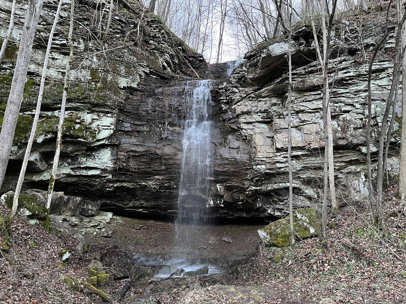
Richman Falls
By Armen Suny · Last verified May 2026

Photo Credits (1)
Difficulty
Moderate
Trail Length
2.4 miles
Trail Type
Out And Back
Elevation Gain
350 ft
About Richman Falls
Richman Falls is a tucked-away cascade set in a quiet, forested pocket of West Virginia. The falls sit on private property managed by Private Land Owner 1 (designation PCON), giving the spot a secluded, almost undiscovered feel that draws hikers looking for a peaceful nature escape. Framed by mature hardwoods, the waterfall is best enjoyed at a relaxed pace—bring a camera and expect a tranquil, low-traffic visit. The most common approach is a moderate 2.4-mile out-and-back hike that climbs roughly 350 feet. Because the site is on private land (manager listed as PVT), visitors should be respectful of property and posted rules or closures. Camping near the falls is limited; the nearest named shelter is Grandview Playground Shelter, about 15.5 km away, so plan overnight stays accordingly.
The Setting
Richman Falls sits at 1,257 feet within Private Land Owner 1, fed by the New River, in the foothills of West Virginia.
Trail & Hike Details
The Approach
The moderate 2.4-mile out-and-back trail gains 350 feet of elevation on the way to the falls.
Trail Description
Trail: 2.4-mile out-and-back (total) with approximately 350 ft elevation gain. Difficulty: Moderate. The route follows a forest footpath through mixed hardwoods with natural tread; expect uneven footing, roots and occasional rocky sections. There is no listed USFS trail number for this approach, and the route lies on private land managed by Private Land Owner 1 (designation PCON, manager: PVT), so confirm access and respect any restrictions before hiking. Minimal facilities and signage are typical—carry a map or GPS and plan for a backcountry-style outing.
What to Expect
Visitors can expect a tranquil waterfall surrounded by dense forest. The area is typically quiet and offers opportunities for photography and relaxation. The waterfall may be more impressive after rainfall.
Accessibility
The trail is not wheelchair accessible. Uneven terrain and elevation changes require steady footing.
Frequently Asked Questions
🐶 Are Dogs Allowed at Richman Falls?
❌ Dogs are not allowed
Are There Any Fees or Permits Required?
🆖 No fees required
🏊 Is There Swimming at Richman Falls?
❌ Swimming is not allowed
When to Visit
Spring and early summer are ideal times to visit, as the waterfall flow is likely to be stronger due to seasonal rainfall.
Seasonal Access
The best time to visit is Spring, Summer, and Fall. Winter access may be limited.
Safety Information
Visitors should be cautious of slippery rocks near the waterfall and uneven trail conditions. Cell service may be limited in the area, so plan accordingly.
Current Water Conditions
2,050 ft³/s
Current discharge — how much water is flowing
Much lower than usual for this time of year
Based on 66 years of record
1.85 ft
Water depth at gauge
74°F
ComfortablePleasant for swimming
7-Day Discharge Trend
What does this mean for your visit?
Flow is well below normal for this time of year, so the waterfall may be a trickle. The water is a comfortable 74 degrees F, pleasant for swimming.
About This Gauge
This gauge is on a nearby waterway and may not reflect exact conditions at the falls.
7-Day Flow Outlook
Based on the USGS gauge NEW RIVER AT HINTON, WV (12 km away).
Today
Low
2337 cfs
3/10Tomorrow
Barely Flowing
2255 cfs
4/10Tue
Barely Flowing
2029 cfs
5/10Wed
Barely Flowing
1889 cfs
5/10Thu
Barely Flowing
1858 cfs
5/10Fri
Barely Flowing
1822 cfs
5/10Sat
Low
2124 cfs
3/10Best window: Tue — barely flowing flow, mostly sunny (trip score 5/10).
Best time of year: this gauge typically runs highest from mid February to late April, peaking in March.
How we calculate this
This is a transparent outlook, not a precise forecast. We take the waterfall's current flow strength (how it ranks against its historical normal for today, from the nearest USGS stream gauge), carry that ranking forward along the gauge's seasonal curve, and nudge it for forecast rain. Confidence is highest for the next day or two and falls further out. Always check official conditions and your own judgment before visiting — high flows can be dangerous.
Know when to go.
Get a free email alert when waterfalls near Meadow Bridge hit peak flow. We only send when conditions are worth the trip — no weekly newsletters, no spam.
Weather Forecast
Location & Access
Getting There
Richman Falls is located in a remote area of West Virginia. Access typically involves driving on rural roads, and the exact location may require local guidance or GPS coordinates.
Get Directions on Google MapsParking
Parking availability is unclear, but visitors may need to park along the roadside or at a nearby trailhead.
Elevation
1,257 feet above sea level
Coordinates
37.777896° N, -80.898979° W
Land Management
Managed by PVT
Visitor Tips & Gear
Wear sturdy shoes as the trail may be uneven or muddy, especially after rain. Bring water and a map or GPS device, as the trail may not be well-marked.
As an Amazon Associate, we earn from qualifying purchases.
With 2.4 miles and 350 ft of elevation gain, sturdy boots and trekking poles will help on this moderate trail. Sun exposure on the trail makes good sun protection a must in summer.

Polarized Sunglasses (Knockaround)
Cuts glare off the water so you actually see the falls — and your photos turn out better too.

Columbia Watertight II Rain Jacket
Packs into its own pocket, seam-sealed, and keeps you dry from spray and surprise rain.

Earth Pak Waterproof Dry Bag
Keeps your phone and gear dry when waterfall mist soaks everything else.

Waterproof Phone Pouch (AiRunTech)
Cheap insurance — take photos right next to the falls without killing your phone.

Timberland Euro Sprint Mid Waterproof
Trusted waterproof boot with premium leather and grippy rubber sole — reliable on rocky, wet trails.

TrailBuddy Trekking Poles
Lightweight aluminum, cork grips, and flip-locks that actually hold — a best-seller for good reason.
Where to Stay

3 Mi to New River Gorge NP! Rafting and Hiking Hub

Sleep Inn Beaver- Beckley

Tru By Hilton Beckley, Wv

Quality Inn New River Gorge
Browse vacation cabins and private rentals nearby
Unique outdoor stays — tents, yurts, and treehouses
Rent a campervan or RV for your waterfall road trip
Some links are affiliate links. We may earn a commission at no extra cost to you.
Nearby Campground
Grandview Playground Shelter
9.7 miles away · 1 sites
Overview The Playground Picnic Shelter is the main shelter at Grandview. It is closest to the main playground and ball fields, located just past the amphitheater.Recreation The Grandview area of New River Gorge National River features five hiking trails, overlooks, a seasonal visitor center, ranger-led activities, summer outdoor dramas (Theatre West Virginia), playgrounds, volleyball court, baseball field, and basketball court.Facilities The Playground Picnic Shelter at Grandview is the largest a
Book on Recreation.govNearby Hot Springs
Hot springs near Meadow Bridge, West Virginia
Alum Springs
Alum Springs flows at 72°F in Pulaski County, Virginia, emerging 18.4 degrees above the 53.6°F ambient temperature at 1,967 fee...
Sweet Chalybeate Spring
Sweet Chalybeate Spring flows at 75 degrees Fahrenheit, emerging 21.1 degrees above ambient temperature at 2,010 feet elevation...

Old Sweet Spring
Old Sweet Spring flows at 73°F from a site 59.3 meters from Jefferson Lane in Greenbrier County, West Virginia. The spring emer...

New River White Sulphur Springs
New River White Sulphur Springs produces 85-degree water that flows 30.3 degrees above ambient temperature at 1,780 feet elevat...
Layton Spring
Layton Spring produces 72-degree water that flows 17.2 degrees above ambient temperature at 1,334 feet elevation in the City of...
Looking for a soak after your hike? Explore more hot springs near Meadow Bridge, West Virginia on SoakingSprings.
Explore West Virginia springsAdditional Information
Nearby Attractions
Nearby attractions may include other hiking trails and natural features in the surrounding area of West Virginia.
Wildlife
The area is home to various wildlife, including birds, deer, and small mammals. Visitors should be cautious of ticks and other insects.
Cities near Richman Falls
Nearby Waterfalls
Writing about Richman Falls? Embed this waterfall on your site for free.