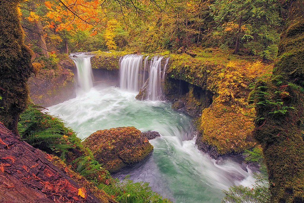
Salt Creek Falls
Oregon • 286 ft
By Armen Suny · Last verified May 2026
Photo Credits (2)
Difficulty
Easy
Trail Length
0.4 miles
Trail Type
Out And Back
Elevation Gain
50 ft
About Salt Creek Falls
Salt Creek Falls is the second tallest single-drop waterfall in Oregon, plunging 286 feet into a scenic canyon. It is located within the Willamette National Forest and is a popular destination for its breathtaking views and accessibility.
The Setting
Salt Creek Falls sits at 1,480 feet within Willamette National Forest, fed by the Mf Willamette River Abv Salt Crk,, in the foothills of Oregon. At 286 feet, it is among the taller waterfalls in Oregon.
Height: 286 feet
Trail & Hike Details
The Approach
The easy hike follows Salmon Creek (#4365), a 0.4-mile out-and-back trail over natural surface. Expect 50 feet of elevation gain with grades of 12-20%. The trail is developed (Class 3).
USFS Trail
SALMON CREEK #4365
Trail Class
Developed
Surface
Avg Grade
USFS Segment
1.48 miTrail Description
The trail to Salt Creek Falls is short and well-maintained, leading to a viewing platform that offers stunning views of the waterfall. The path is paved and suitable for most visitors, including those with mobility challenges.
What to Expect
The falls plunge 286 feet. Dogs are welcome.
Accessibility
The trail is short and relatively flat, but the surface may be uneven. Contact the managing agency for accessibility details.
Frequently Asked Questions
🐶 Are Dogs Allowed at Salt Creek Falls?
✅ Dogs are allowed
Are There Any Fees or Permits Required?
🤑 Fee: $5.00
🏊 Is There Swimming at Salt Creek Falls?
❌ Swimming is not allowed
When to Visit
Spring is an excellent time to visit when the waterfall is at its fullest due to snowmelt. Summer and fall also offer great views, while winter provides a unique perspective with potential snow and ice formations.
Seasonal Access
The best time to visit is Spring, Summer, Fall, and Winter. Check with Willamette National Forest for seasonal road closures.
Safety Information
Stay on designated trails and viewing platforms. The area near the waterfall can be slippery, especially in wet or icy conditions. Exercise caution and supervise children closely.
Current Water Conditions
556 ft³/s
Current discharge — how much water is flowing
About average for this time of year
Based on 91 years of record
2.89 ft
Water depth at gauge
53°F
ColdBracing — limit time in water
7-Day Discharge Trend
What does this mean for your visit?
Flow is about average for this time of year. Water temperature is a bracing 53 degrees F, limit your time in the water.
About This Gauge
7-Day Flow Outlook
Based on the USGS gauge MF WILLAMETTE RIVER ABV SALT CRK, NEAR OAKRIDGE,OR (7 km away).
Today
Low
601 cfs
4/10Tomorrow
Low
619 cfs
4/10Sun
Low
606 cfs
4/10Mon
Low
593 cfs
4/10Tue
Low
574 cfs
4/10Wed
Barely Flowing
509 cfs
5/10Thu
Low
522 cfs
4/10Best window: Wed — barely flowing flow, mostly sunny (trip score 5/10).
Best time of year: this gauge typically runs highest from mid November to late December, peaking in January.
How we calculate this
This is a transparent outlook, not a precise forecast. We take the waterfall's current flow strength (how it ranks against its historical normal for today, from the nearest USGS stream gauge), carry that ranking forward along the gauge's seasonal curve, and nudge it for forecast rain. Confidence is highest for the next day or two and falls further out. Always check official conditions and your own judgment before visiting — high flows can be dangerous.
Know when to go.
Get a free email alert when waterfalls near Oakridge hit peak flow. We only send when conditions are worth the trip — no weekly newsletters, no spam.
Weather Forecast
Location & Access
Getting There
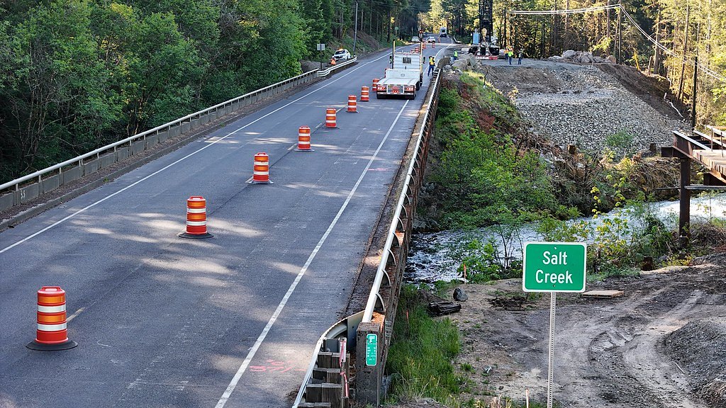
Salt Creek Falls is located off Highway 58, approximately 23 miles southeast of Oakridge, Oregon. The parking area is well-marked and easily accessible by car.
Get Directions on Google MapsParking
There is a paved parking lot near the viewing area. A Northwest Forest Pass or a $5 day-use fee is required for parking.
Elevation
1,480 feet above sea level
Coordinates
43.762407° N, -122.371989° W
Land Management
Managed by USFS
Visitor Tips & Gear
Visit early in the day to avoid crowds, especially during summer weekends. Bring a camera to capture the stunning views. If visiting in winter, check road conditions and consider bringing traction devices for icy paths.
As an Amazon Associate, we earn from qualifying purchases.
For this easy 0.4 miles trail, lightweight trail shoes and a water bottle are usually sufficient. Icy conditions are common in winter — traction cleats are a smart addition.

Columbia Watertight II Rain Jacket
Packs into its own pocket, seam-sealed, and keeps you dry from spray and surprise rain.

Polarized Sunglasses (Knockaround)
Cuts glare off the water so you actually see the falls — and your photos turn out better too.

Earth Pak Waterproof Dry Bag
Keeps your phone and gear dry when waterfall mist soaks everything else.

Waterproof Phone Pouch (AiRunTech)
Cheap insurance — take photos right next to the falls without killing your phone.

Kahtoola MICROspikes
Cult-favorite traction cleats that grip ice and wet rock — essential for winter waterfall hikes.

JOBY GorillaPod Starter Kit
Wraps around railings and rocks for long-exposure waterfall shots — no flat surface needed.
Where to Stay

Cascade Motel

Oakridge Inn & Suites

La Quinta Inn & Suites by Wyndham Springfield

Holiday Inn Express : Eugene - Springfield by IHG
Browse vacation cabins and private rentals nearby
Unique outdoor stays — tents, yurts, and treehouses
Rent a campervan or RV for your waterfall road trip
Some links are affiliate links. We may earn a commission at no extra cost to you.
Nearby Campground
Middle Fork Ranger District (Hwy 58)
8.1 miles away · 0 sites
Middle Fork Ranger District (US Highway 58)Middle Fork Ranger District is the southern part of the forest, bordering the Deschutes and Umpqua National Forests. Accessible from the west on Highway 58 from Eugene, OR, or from the south via Highway 58.Spend some time exploring Waldo Lake, one of the gems of the forest, but don’t forget to get out on some of the great mountain biking, hiking, and horse trails in this area.HikingBackpacking and day hikes can be found all over the district including, F
Book on Recreation.govNearby Hot Springs
Hot springs near Oakridge, Oregon
Kitson Hot Springs
Kitson Hot Springs flows at 109°F within Willamette National Forest at 1,664 feet elevation, positioned just 17 meters from For...
Wall Creek Warm Springs
Wall Creek Warm Springs flows at 106°F deep within Willamette National Forest at 2,362 feet elevation on the western Cascades s...

Mccredie Springs
McCredie Springs flows at 163°F along Salt Creek in the Willamette National Forest, creating one of western Oregon's most popul...

Cougar Reservoir Hot Springs
Cougar Reservoir Hot Springs, widely known as Terwilliger Hot Springs, flows at 111 degrees Fahrenheit with roadside access req...

Umpqua Hot Springs
Umpqua Hot Springs flows at 117°F from multiple geothermal sources along the North Umpqua River in Lane County, forming cascadi...
Foley Springs
Foley Springs emerges at 178°F in the Cascade Range of Lane County, making it one of Oregon's hottest thermal features with rec...
Looking for a soak after your hike? Explore more hot springs near Oakridge, Oregon on SoakingSprings.
Explore Oregon springsAdditional Information
Nearby Attractions
Nearby attractions include Diamond Creek Falls, Waldo Lake, and the Willamette Pass Ski Area.
Wildlife
The area is home to a variety of wildlife, including birds, deer, and small mammals. Keep an eye out for native flora and fauna.
Cities near Salt Creek Falls
Nearby Waterfalls
Other waterfalls named Salt Creek Falls
1 other waterfall shares this name across the U.S.
Writing about Salt Creek Falls? Embed this waterfall on your site for free.