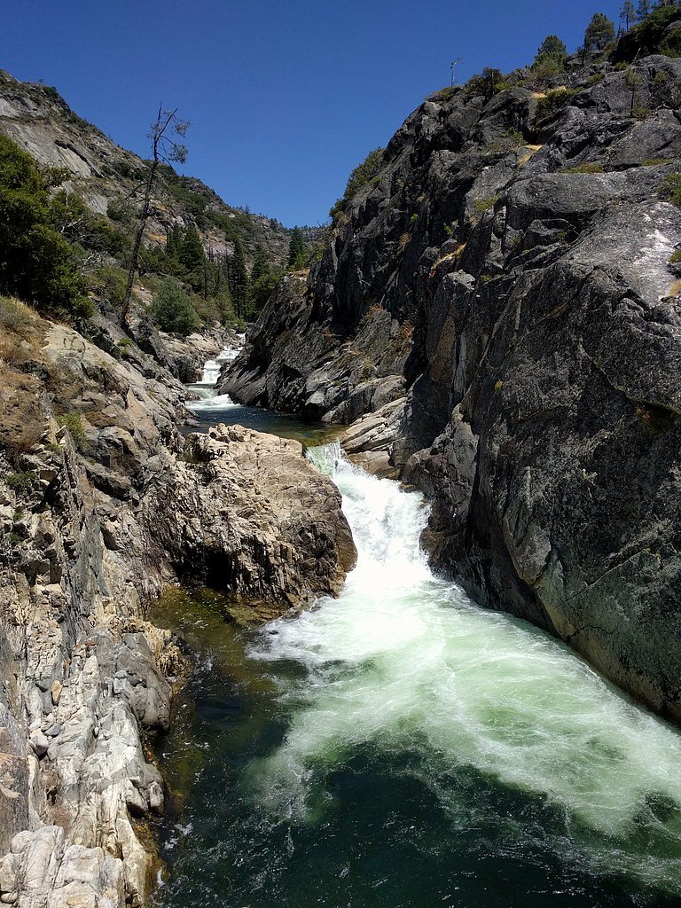
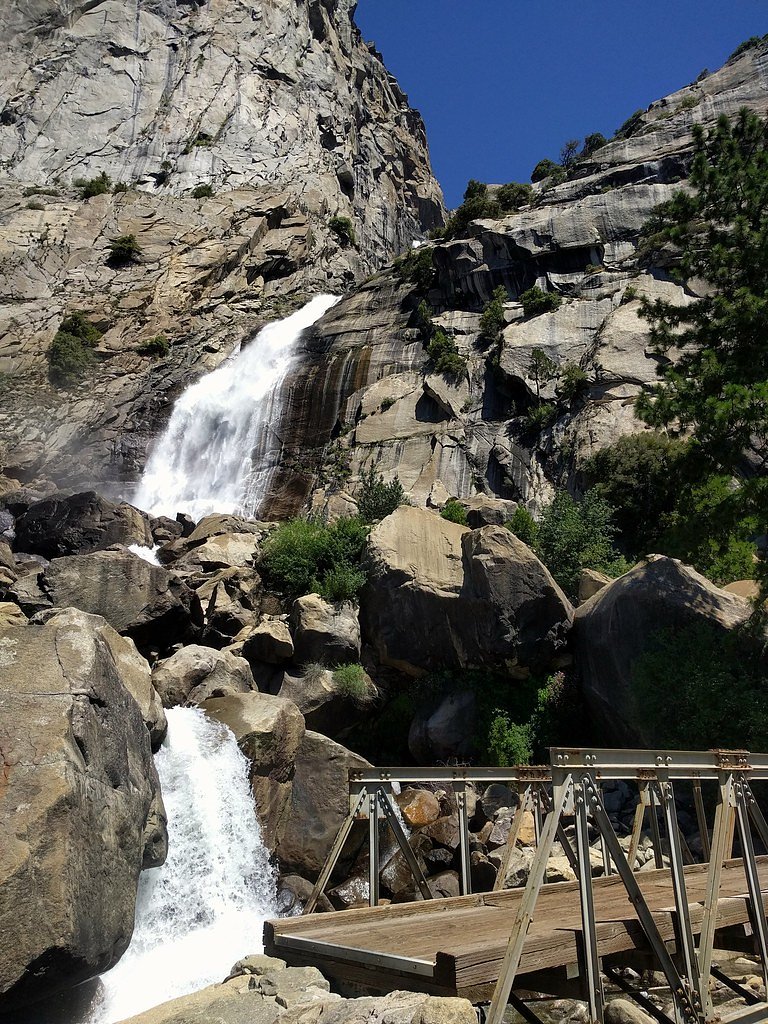
Rancheria Falls
California • Yosemite National Park
By Armen Suny · Last verified Mar 2026
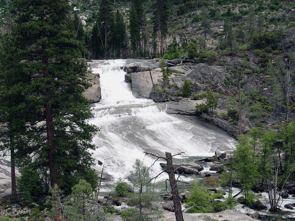
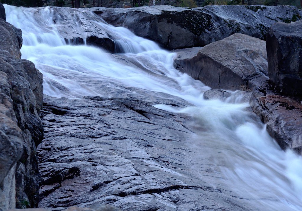
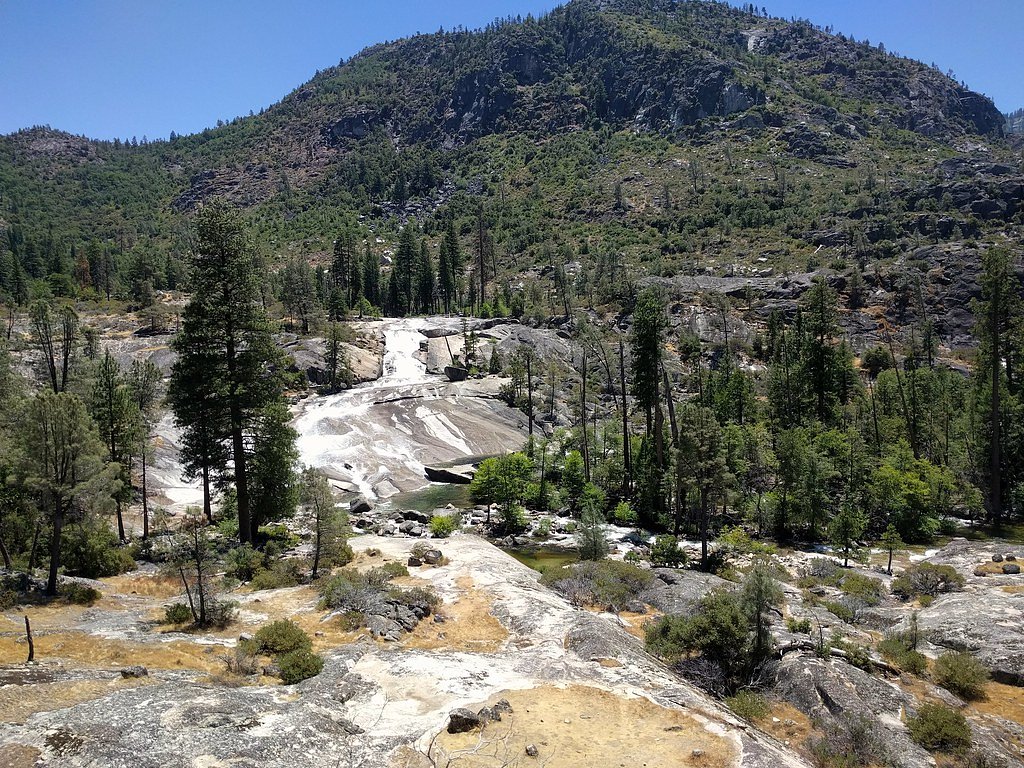
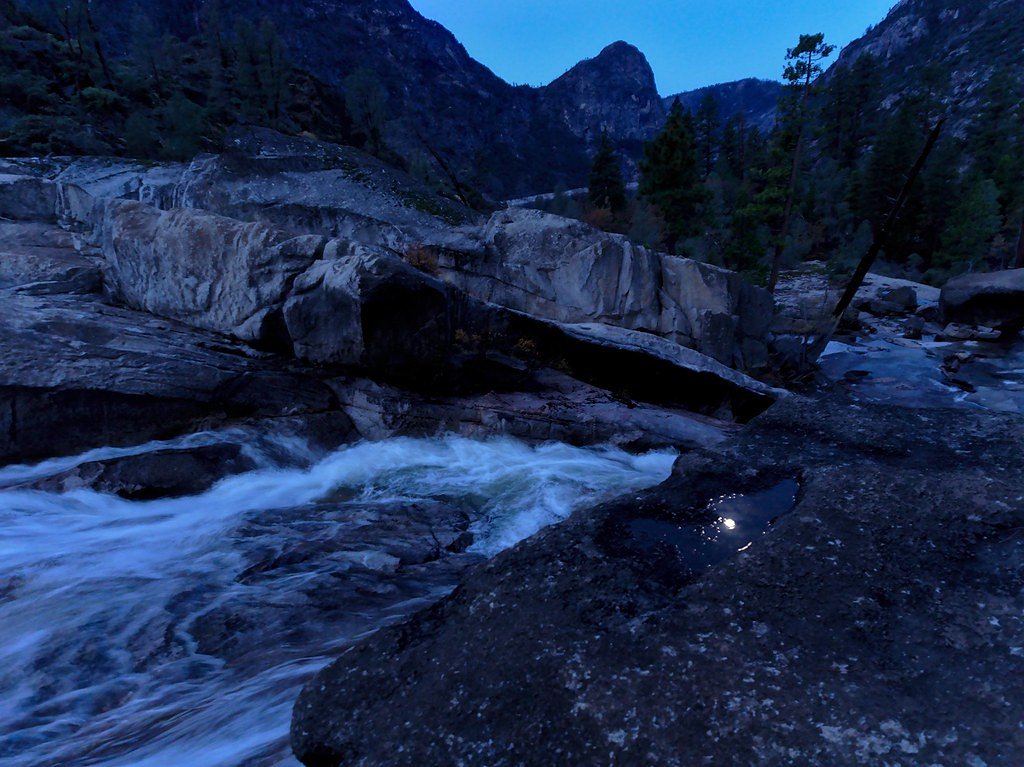

Photo Credits (5)
Difficulty
Easy
Trail Length
2.0 miles
Trail Type
Out And Back
Elevation Gain
200 ft
About Rancheria Falls
Rancheria Falls lies within Yosemite National Park and is managed by the National Park Service. The cascade sits along Falls Creek (also known as the Falls River), the tributary that begins near the park’s northern boundary and flows about 24 miles to the Tuolumne River at Hetch Hetchy Reservoir. That same creek drops over two well-known waterfalls as it descends, and sections of the Pacific Crest Trail and other park routes follow the creek for much of its course — so the area around Rancheria Falls is part of a larger, scenic creek corridor that appeals to both day hikers and long-distance trekkers. The hike to the falls is a peaceful, accessible outing set in classic Yosemite terrain. With a short approach and the sound of rushing water as a reward, Rancheria Falls is an inviting stop for visitors exploring this less-crowded section of the park. As with all visits in Yosemite, expect basic backcountry conditions and follow NPS regulations and signage while enjoying the scenery.
The Setting
Rancheria Falls sits at 4,629 feet within Yosemite National Park, in the mountains of California.
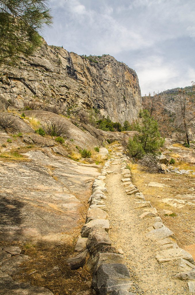
Trail & Hike Details
The Approach
The easy 2.0-mile out-and-back trail gains 200 feet of elevation on the way to the falls.
Trail Description
Trail stats (NPS): approximately 2.0 miles, out-and-back, with about 200 feet of elevation gain; rated easy. The route follows creekside park trails and is generally a short, gentle hike suitable for most visitors. Park-provided trail surface/grade/class details are not specified in the park data, so expect typical natural footpath conditions (roots, rocks, variable footing) and plan footwear accordingly.
What to Expect
Dogs are welcome.
Accessibility
The trail is not wheelchair accessible. Uneven terrain and elevation changes require steady footing.
Frequently Asked Questions
🐶 Are Dogs Allowed at Rancheria Falls?
✅ Dogs are allowed
Are There Any Fees or Permits Required?
🤑 Fee: $5.00
🏊 Is There Swimming at Rancheria Falls?
❌ Swimming is not allowed
When to Visit
The best time to visit Rancheria Falls is in the spring or early summer when the water flow is strongest. Fall is also a good time to visit for cooler weather and fewer crowds.
Seasonal Access
The best time to visit is Spring, Summer, and Fall. Winter access may be limited. Check with Yosemite National Park for current conditions.
Safety Information
Be cautious of slippery rocks near the waterfall. Always stay on the marked trail to avoid getting lost. Check weather conditions before visiting, as the trail may be icy or snow-covered in winter.
Current Water Conditions
374 ft³/s
Current discharge — how much water is flowing
About average for this time of year
Based on 19 years of record
9.41 ft
Water depth at gauge
61°F
CoolRefreshing for swimming
7-Day Discharge Trend
What does this mean for your visit?
Flow is about average for this time of year. Water temperature is a refreshing 61 degrees F, good for a quick swim. Mineral content is typical.
Water Quality
Conductance
Dissolved minerals in the water
About This Gauge
7-Day Flow Outlook
Based on the USGS gauge TUOLUMNE R A GRAND CYN OF TUOLUMNE AB HETCH HETCHY (6 km away).
Today
Low
410 cfs
4/10Tomorrow
Low
369 cfs
6/10Mon
Barely Flowing
361 cfs
5/10Tue
Barely Flowing
351 cfs
5/10Wed
Barely Flowing
313 cfs
5/10Thu
Barely Flowing
292 cfs
5/10Fri
Barely Flowing
307 cfs
5/10Best window: Tomorrow — low flow, sunny (trip score 6/10).
Best time of year: this gauge typically runs highest from late March to late June, peaking in May.
How we calculate this
This is a transparent outlook, not a precise forecast. We take the waterfall's current flow strength (how it ranks against its historical normal for today, from the nearest USGS stream gauge), carry that ranking forward along the gauge's seasonal curve, and nudge it for forecast rain. Confidence is highest for the next day or two and falls further out. Always check official conditions and your own judgment before visiting — high flows can be dangerous.
Know when to go.
Get a free email alert when waterfalls near Foresta hit peak flow. We only send when conditions are worth the trip — no weekly newsletters, no spam.
Weather Forecast
Location & Access
Getting There
Rancheria Falls is located near Huntington Lake in the Sierra National Forest. From Fresno, take Highway 168 east to Huntington Lake. The trailhead is located near the Rancheria Campground, which is well-marked and easy to find.
Get Directions on Google MapsParking
Parking is available near the Rancheria Campground. There is a designated parking area for hikers accessing the trail to Rancheria Falls.
Elevation
4,629 feet above sea level
Coordinates
37.954921° N, -119.710452° W
Land Management
Managed by NPS
Visitor Tips & Gear
Arrive early during weekends or holidays to secure parking. Wear sturdy shoes as the trail may have uneven sections. Bring insect repellent during warmer months.
As an Amazon Associate, we earn from qualifying purchases.
This easy 2.0 miles hike is straightforward — comfortable trail shoes and plenty of water should do. Sun exposure on the trail makes good sun protection a must in summer.
America the Beautiful Annual Pass
Covers entrance fees at 2,000+ federal recreation sites — required at most National Parks.

Polarized Sunglasses (Knockaround)
Cuts glare off the water so you actually see the falls — and your photos turn out better too.

Columbia Watertight II Rain Jacket
Packs into its own pocket, seam-sealed, and keeps you dry from spray and surprise rain.

Earth Pak Waterproof Dry Bag
Keeps your phone and gear dry when waterfall mist soaks everything else.

Waterproof Phone Pouch (AiRunTech)
Cheap insurance — take photos right next to the falls without killing your phone.

JOBY GorillaPod Starter Kit
Wraps around railings and rocks for long-exposure waterfall shots — no flat surface needed.

Osprey Daylite Daypack
Light, organized, and just the right size for a day hike — fits water, snacks, and layers.
Where to Stay

Rush Creek Lodge at Yosemite

Yosemite Westgate Lodge

Evergreen Lodge at Yosemite

Yosemite Basecamp
Browse vacation cabins and private rentals nearby
Unique outdoor stays — tents, yurts, and treehouses
Rent a campervan or RV for your waterfall road trip
Some links are affiliate links. We may earn a commission at no extra cost to you.
Nearby Campground
Yosemite Creek Campground
10.8 miles away · 76 sites
Overview Yosemite Creek Campground is closed for the winter.Tucked away among the pines is the hidden gem of Yosemite Creek campground. Accessing this campground is an adventure down a rutted, 5-mile, single-lane dirt road. Motorhomes and trailers are NOT allowed.Recreation Your adventure awaits! Hiking, swimming, bouldering, napping (some of us are tired!), bird watching; the possibilities are as great as your imagination. Be sure to bring bug spray and sunscreen, plenty of water, and dress in l
Book on Recreation.govNearby Hot Springs
Hot springs near Foresta, California

Unnamed Spring Mono County 5
This 72-degree thermal spring near Bridgeport sits at 6,383 feet elevation, requiring a short 160-meter walk from the road in M...

Unnamed Spring Mono County 6
This 91-degree thermal spring near Mammoth Lakes delivers exceptional warmth, running 42 degrees above the cool ambient air whe...
Buckeye Hot Spring
Buckeye Hot Spring flows at 140°F from the eastern Sierra Nevada in Mono County at 6,963 feet elevation on US Forest Service la...
Paoha Island Springs
Rising from the volcanic island of Paoha in Mono Lake, Paoha Island Springs reaches 181 degrees Fahrenheit—one of California's ...
Hot Spring
Hot Spring near Bridgeport emerges at 151°F just 130 feet from the road, making it perhaps the most accessible high-temperature...
Fales Hot Springs
Fales Hot Springs reaches 180°F in the high Sierra Nevada, flowing 137°F hotter than the surrounding air at 7,491 feet elevatio...
Looking for a soak after your hike? Explore more hot springs near Foresta, California on SoakingSprings.
Explore California springsAdditional Information
Nearby Attractions
Huntington Lake, China Peak Mountain Resort, and other hiking trails in the Sierra National Forest.
Wildlife
Visitors may encounter wildlife such as deer, squirrels, and various bird species. Be cautious of bears in the area and store food properly.
Cities near Rancheria Falls
Nearby Waterfalls
Other waterfalls named Rancheria Falls
1 other waterfall shares this name across the U.S.
Writing about Rancheria Falls? Embed this waterfall on your site for free.