Rambiker Falls
By Armen Suny · Last verified May 2026
Difficulty
Moderate
Trail Length
2.4 miles
Trail Type
Out And Back
Elevation Gain
350 ft
About Rambiker Falls
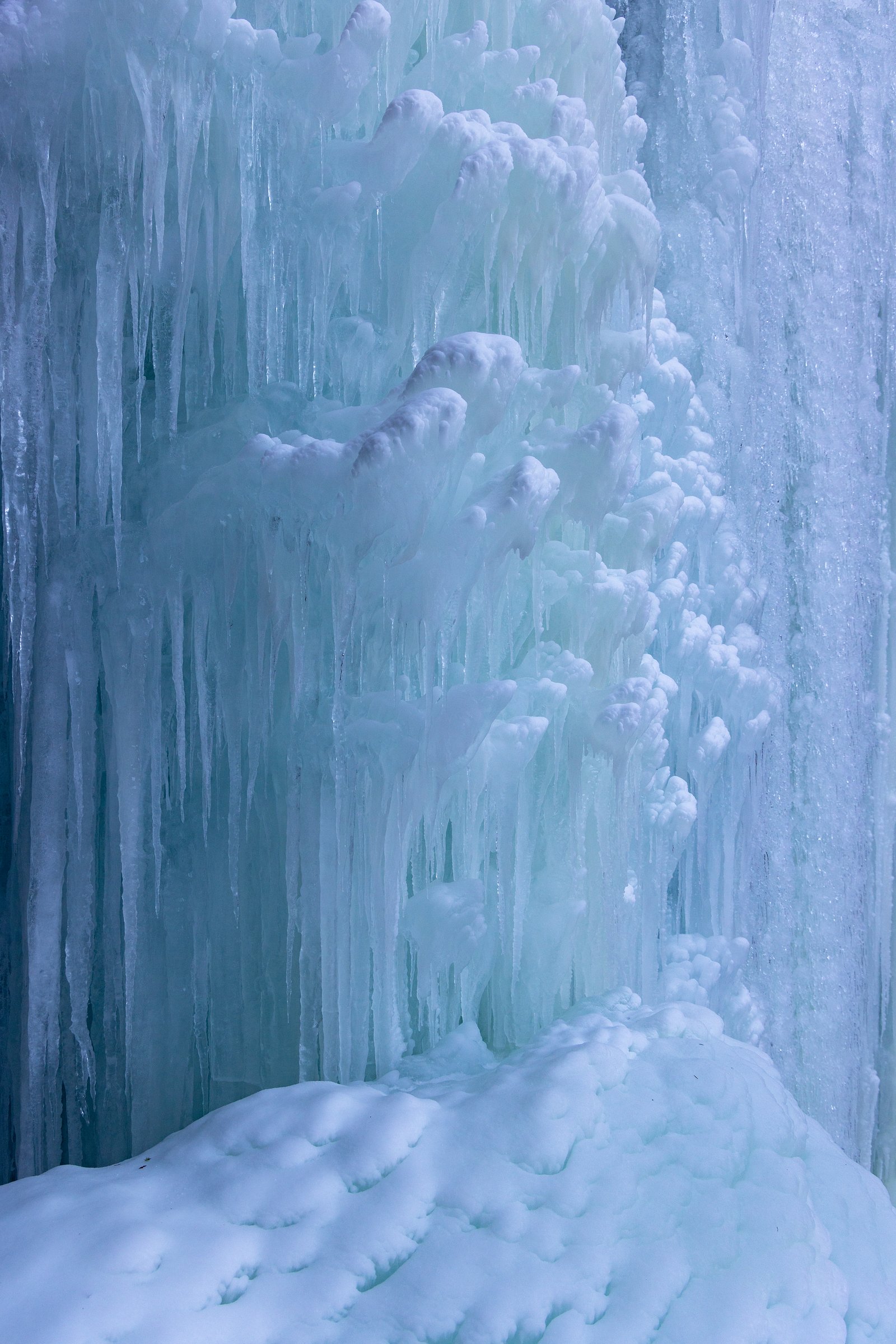
Rambiker Falls is a quietly scenic cascade tucked into the forested slopes of Idaho’s St. Joe National Forest, managed by the U.S. Forest Service. The falls sit in a peaceful stand of timber and offer a rewarding short outing for hikers who enjoy wooded creekside scenery and the sound of rushing water away from busier trailheads. Access to the falls is reached via trails managed by the USFS — the approach includes the St Joe Lake Spur (Trail #49A). The hike is best suited to visitors comfortable with a moderately paced out-and-back route: about 2.4 miles round-trip with roughly 350 feet of elevation gain. The short spur to the creek is a native-surface, steeper tread, so sturdy footwear and basic route-awareness are recommended.
The Setting
Rambiker Falls sits at 6,250 feet within St. Joe National Forest, fed by the St Joe River, in the high mountains of Idaho.
Trail & Hike Details
The Approach
The moderate hike follows St Joe Lake Spur (#49A), a 2.4-mile out-and-back trail over natural surface. Expect 350 feet of elevation gain with grades of 10-12%. The trail is developed (Class 3).
USFS Trail
ST JOE LAKE SPUR #49A
Trail Class
Developed
Surface
Avg Grade
USFS Segment
0.15 miTrail Description
Trail type: out-and-back; total length: 2.4 miles; elevation gain: ~350 ft; difficulty: moderate. The final approach to Rambiker Falls uses the St Joe Lake Spur (USFS Trail #49A). The spur is recorded at about 0.15 GIS miles, is surfaced with NAT (native material), and is classified as a Class 3 tread with a typical grade of 10–12%. Expect natural, uneven footing on the spur and some steeper sections; the main approach otherwise follows a moderate-grade forest trail under USFS management.
What to Expect
Visitors can expect a tranquil natural setting with a waterfall surrounded by forested landscapes. The area may be remote, so preparation is key.
Accessibility
The trail is not wheelchair accessible. Uneven terrain and elevation changes require steady footing.
Frequently Asked Questions
🐶 Are Dogs Allowed at Rambiker Falls?
❌ Dogs are not allowed
Are There Any Fees or Permits Required?
🆖 No fees required
🏊 Is There Swimming at Rambiker Falls?
❌ Swimming is not allowed
When to Visit
Spring and early summer are typically the best times to visit, as water flow is likely to be at its peak due to snowmelt.
Seasonal Access
The best time to visit is Spring, Summer, and Fall. Access roads and trails may close during winter due to snow. Check with St. Joe National Forest for seasonal road closures.
Safety Information
The trail may be remote and poorly marked. Visitors should prepare for changing weather conditions, carry navigation tools, and inform someone of their plans before visiting.
Current Water Conditions
284 ft³/s
Current discharge — how much water is flowing
Lower than usual for this time of year
Based on 28 years of record
2.09 ft
Water depth at gauge
7-Day Discharge Trend
What does this mean for your visit?
Flow is lower than usual for this time of year.
About This Gauge
This gauge is on a nearby waterway and may not reflect exact conditions at the falls.
7-Day Flow Outlook
Based on the USGS gauge St Joe River at Red Ives Ranger Station, ID (21 km away).
Today
Barely Flowing
307 cfs
3/10Tomorrow
Low
306 cfs
4/10Tue
Low
293 cfs
4/10Wed
Low
282 cfs
4/10Thu
Low
270 cfs
4/10Fri
Low
274 cfs
4/10Sat
Barely Flowing
244 cfs
5/10Best window: Sat — barely flowing flow, sunny (trip score 5/10).
Best time of year: this gauge typically runs highest from early April to early July, peaking in May.
How we calculate this
This is a transparent outlook, not a precise forecast. We take the waterfall's current flow strength (how it ranks against its historical normal for today, from the nearest USGS stream gauge), carry that ranking forward along the gauge's seasonal curve, and nudge it for forecast rain. Confidence is highest for the next day or two and falls further out. Always check official conditions and your own judgment before visiting — high flows can be dangerous.
Know when to go.
Get a free email alert when waterfalls near St. Regis hit peak flow. We only send when conditions are worth the trip — no weekly newsletters, no spam.
Weather Forecast
Location & Access
Getting There
The exact location and directions to Rambiker Falls are not well-documented. Visitors are advised to consult local hiking resources or contact nearby ranger stations for guidance.
Get Directions on Google MapsParking
Parking availability is unclear. It is recommended to check with local authorities or trail resources for updated information.
Elevation
6,250 feet above sea level
Coordinates
47.019365° N, -115.088190° W
Land Management
Managed by USFS
Visitor Tips & Gear
Bring a detailed map or GPS device as the trail may not be well-marked. Check weather conditions before visiting and wear sturdy footwear.
This trail sits at 6,250 ft above sea level
Elevated TrailUV radiation is roughly 25% stronger at this elevation than at sea level, and the dry air accelerates dehydration. Extra sun protection and fluids go a long way.
As an Amazon Associate, we earn from qualifying purchases.

Coppertone Sport SPF 50 Sunscreen
UV intensity jumps ~4% per 1,000 ft — at this elevation you can burn in half the time.

Sun Bum SPF 30 Lip Balm (3-Pack)
Lips have almost no natural UV protection and burn fast in thin, dry mountain air.

Liquid I.V. Electrolyte Packets
You lose moisture ~2x faster at elevation — electrolytes help you absorb water efficiently.

ROCKNIGHT Polarized UV400 Sunglasses
High-altitude glare off rock and water is intense — UV400 lenses block 99%+ of UVA/UVB.
As an Amazon Associate, we earn from qualifying purchases.
With 2.4 miles and 350 ft of elevation gain, sturdy boots and trekking poles will help on this moderate trail. Sun exposure on the trail makes good sun protection a must in summer.

Columbia Watertight II Rain Jacket
Packs into its own pocket, seam-sealed, and keeps you dry from spray and surprise rain.

Earth Pak Waterproof Dry Bag
Keeps your phone and gear dry when waterfall mist soaks everything else.

Waterproof Phone Pouch (AiRunTech)
Cheap insurance — take photos right next to the falls without killing your phone.

Timberland Euro Sprint Mid Waterproof
Trusted waterproof boot with premium leather and grippy rubber sole — reliable on rocky, wet trails.

TrailBuddy Trekking Poles
Lightweight aluminum, cork grips, and flip-locks that actually hold — a best-seller for good reason.

Polarized Sunglasses (Knockaround)
Cuts glare off the water so you actually see the falls — and your photos turn out better too.
Where to Stay

Big Sky Motel

Peaceful Superior Home w/ Fire Pit & Mtn View

The Lodge at Forest Grove

Rustic Cabin Rental in the Tranquil Montana Wilderness near Missoula
Browse vacation cabins and private rentals nearby
Unique outdoor stays — tents, yurts, and treehouses
Rent a campervan or RV for your waterfall road trip
Some links are affiliate links. We may earn a commission at no extra cost to you.
Nearby Campground
Cedars Campground
10.2 miles away · 0 sites
Cedars campground has five developed campsites situated alongside the North Fork of the Clearwater River and Long Creek. A loop of the Idaho Centennial Trail passes by the campground, and other hiking/horse riding trails are nearby. Anglers will also love this spot as trout are abundant.
Book on Recreation.govNearby Hot Springs
Hot springs near St. Regis, Idaho
Quinns Hot Springs
Quinns Hot Springs flows at 109 degrees Fahrenheit in the Clark Fork River valley of Sanders County, Montana, at a low elevatio...
Weir Creek Hot Springs
Weir Creek Hot Springs surfaces at 117°F with strongly alkaline water (pH 9.4) in Idaho's Clearwater National Forest. Located a...

Colgate Warm Springs
Colgate Warm Springs registers pH 9.5, placing it among the most alkaline thermal features in Idaho. The water emerges at 106 d...

Jerry Johnson Hot Springs
Jerry Johnson Hot Springs is one of Idaho's most visited backcountry soaks, flowing at 118 degrees Fahrenheit along the Lochsa ...

Lolo Hot Springs, Granite Springs
Lolo Hot Springs registers 111°F with unusually alkaline water at pH 9.3 and very low mineral content, dominated by 52 mg/L sod...
Green Springs
Green Springs flows at 79°F on the Flathead Reservation in Sanders County, Montana, at 2,813 feet — one of the lower-elevation ...
Looking for a soak after your hike? Explore more hot springs near St. Regis, Idaho on SoakingSprings.
Explore Idaho springsAdditional Information
Nearby Attractions
Nearby attractions are not well-documented. Visitors may explore other natural areas in Idaho for additional outdoor activities.
Wildlife
The area may host typical Idaho wildlife such as deer, birds, and small mammals. Be cautious of potential encounters with bears or other large animals.
Cities near Rambiker Falls
Nearby Waterfalls
Writing about Rambiker Falls? Embed this waterfall on your site for free.