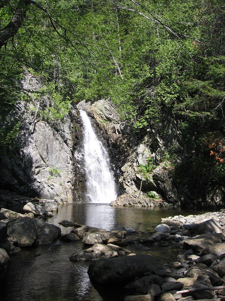
Poplar Stream Falls
By Armen Suny · Last verified Mar 2026
Photo Credits (1)
Difficulty
Moderate
Trail Length
2.4 miles
Trail Type
Out And Back
Elevation Gain
350 ft
About Poplar Stream Falls
Poplar Stream Falls is a picturesque waterfall located near Carrabassett Valley, Maine. It features two distinct cascades surrounded by lush forest, making it a popular spot for hikers and nature enthusiasts.
The Setting
Poplar Stream Falls sits at 1,060 feet along the Dead River, in the foothills of Maine.
Trail & Hike Details
The Approach
The moderate 2.4-mile out-and-back trail gains 350 feet of elevation on the way to the falls.
Trail Description
The trail to Poplar Stream Falls is a short and relatively flat hike through a wooded area. It is well-marked and suitable for most visitors, including families with children. The trail leads to a viewing area where both cascades of the falls can be seen.
What to Expect
Dogs are welcome.
Accessibility
The trail is not wheelchair accessible. Uneven terrain and elevation changes require steady footing.
Frequently Asked Questions
🐶 Are Dogs Allowed at Poplar Stream Falls?
✅ Dogs are allowed
Are There Any Fees or Permits Required?
🆖 No fees required
🏊 Is There Swimming at Poplar Stream Falls?
❌ Swimming is not allowed
When to Visit
Spring and early summer are ideal for visiting, as the water flow is typically strongest during these seasons. Fall offers beautiful foliage, while summer provides warmer weather for hiking.
Seasonal Access
The best time to visit is Spring, Summer, and Fall. Winter access may be limited.
Safety Information
Exercise caution near the falls, as rocks can be slippery. Be aware of changing weather conditions, and avoid visiting during heavy rain or snowmelt, as the trail may become hazardous.
Current Water Conditions
1,290 ft³/s
Current discharge — how much water is flowing
Higher than usual for this time of year
Based on 55 years of record
5.55 ft
Water depth at gauge
7-Day Discharge Trend
What does this mean for your visit?
The water is flowing higher than usual for this time of year.
About This Gauge
This gauge is on a nearby waterway and may not reflect exact conditions at the falls.
7-Day Flow Outlook
Based on the USGS gauge Dead River near Dead River, Maine (14 km away).
Today
Low
1471 cfs
3/10Tomorrow
Low
1686 cfs
3/10Mon
Barely Flowing
1624 cfs
5/10Tue
Barely Flowing
1607 cfs
3/10Wed
Low
1742 cfs
3/10Thu
Low
2291 cfs
3/10Fri
Low
2247 cfs
3/10Best window: Mon — barely flowing flow, sunny (trip score 5/10).
Best time of year: this gauge typically runs highest from early May to early June, peaking in May.
How we calculate this
This is a transparent outlook, not a precise forecast. We take the waterfall's current flow strength (how it ranks against its historical normal for today, from the nearest USGS stream gauge), carry that ranking forward along the gauge's seasonal curve, and nudge it for forecast rain. Confidence is highest for the next day or two and falls further out. Always check official conditions and your own judgment before visiting — high flows can be dangerous.
Know when to go.
Get a free email alert when waterfalls near Kingfield hit peak flow. We only send when conditions are worth the trip — no weekly newsletters, no spam.
Weather Forecast
Location & Access
Getting There
Poplar Stream Falls is located off Poplar Stream Road, near the Carrabassett Valley area. The trailhead can be accessed by driving along a dirt road, which may be rough in certain conditions. Visitors should check local conditions before heading out.
Get Directions on Google MapsParking
There is a small parking area near the trailhead, but space may be limited during peak seasons.
Elevation
1,060 feet above sea level
Coordinates
45.101166° N, -70.193955° W
Visitor Tips & Gear
Wear sturdy footwear, as the trail may be muddy or slippery, especially after rain. Bug spray is recommended during warmer months. Arrive early to secure parking, especially during weekends or peak seasons.
As an Amazon Associate, we earn from qualifying purchases.
With 2.4 miles and 350 ft of elevation gain, sturdy boots and trekking poles will help on this moderate trail. Sun exposure on the trail makes good sun protection a must in summer.

Polarized Sunglasses (Knockaround)
Cuts glare off the water so you actually see the falls — and your photos turn out better too.

Columbia Watertight II Rain Jacket
Packs into its own pocket, seam-sealed, and keeps you dry from spray and surprise rain.

Earth Pak Waterproof Dry Bag
Keeps your phone and gear dry when waterfall mist soaks everything else.

Waterproof Phone Pouch (AiRunTech)
Cheap insurance — take photos right next to the falls without killing your phone.

Timberland Euro Sprint Mid Waterproof
Trusted waterproof boot with premium leather and grippy rubber sole — reliable on rocky, wet trails.

TrailBuddy Trekking Poles
Lightweight aluminum, cork grips, and flip-locks that actually hold — a best-seller for good reason.
Where to Stay

Rangeley Saddleback Inn

Rangeley Lake Resort a Ramada by Wyndham

Sugarloaf Inn

Charming Bingham Home Near Outdoor Adventure, Pet Friendly!
Browse vacation cabins and private rentals nearby
Unique outdoor stays — tents, yurts, and treehouses
Rent a campervan or RV for your waterfall road trip
Some links are affiliate links. We may earn a commission at no extra cost to you.
Additional Information
Nearby Attractions
Sugarloaf Mountain, Carrabassett Valley trails, and the Narrow Gauge Pathway are nearby attractions worth exploring.
Wildlife
The area is home to a variety of wildlife, including birds, deer, and small mammals. Visitors should be cautious of ticks during warmer months.
Cities near Poplar Stream Falls
Nearby Waterfalls
Writing about Poplar Stream Falls? Embed this waterfall on your site for free.