Photo Credits (4)
Difficulty
Easy
Trail Length
0.8 miles
Trail Type
Out And Back
Elevation Gain
200 ft
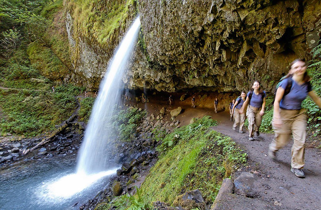
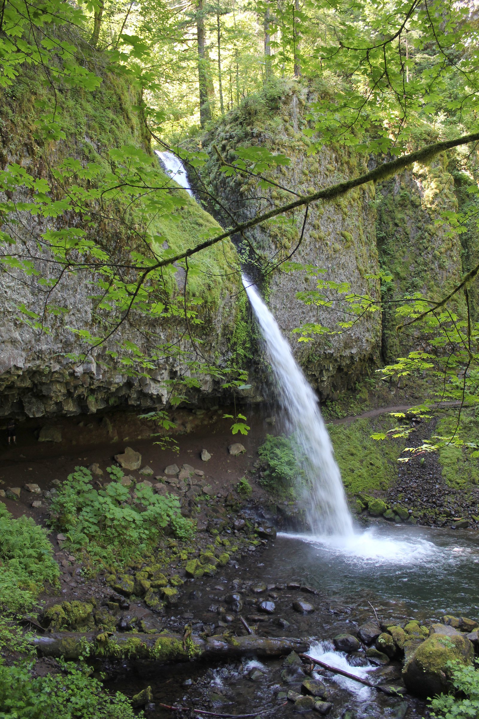
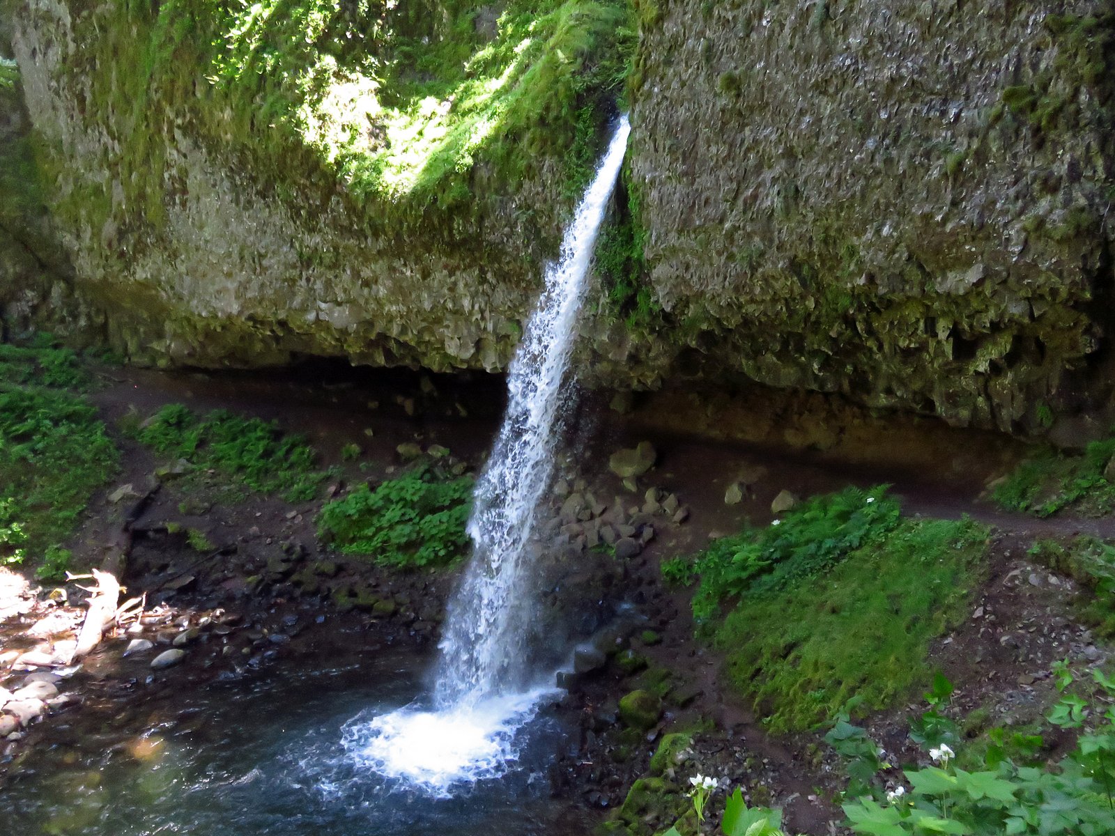
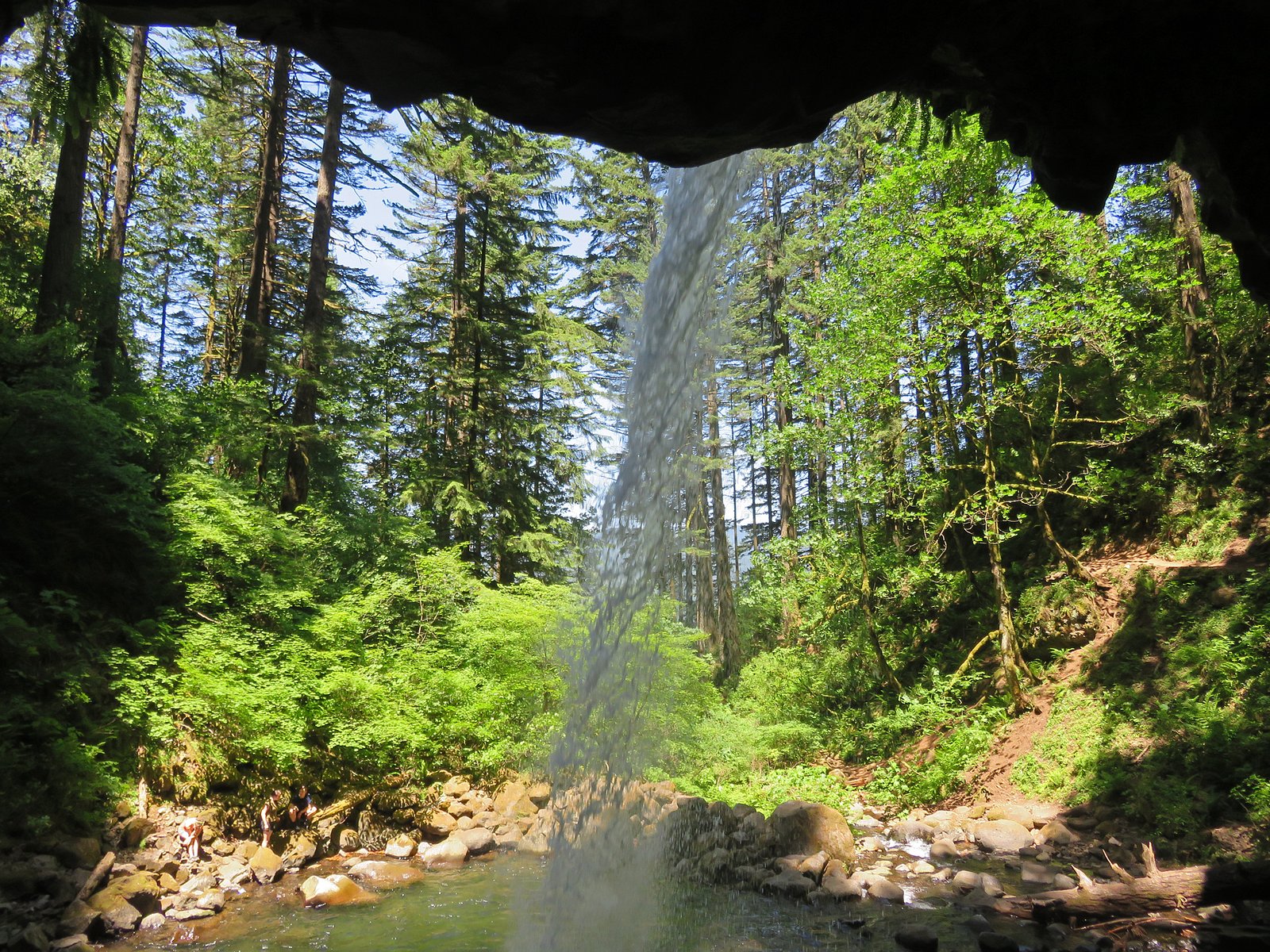
About Ponytail Falls
Ponytail Falls is a picturesque 75-foot cascade tucked into California’s Klamath National Forest and managed by the U.S. Forest Service. Set among dense forest, the falls make for a rewarding short outing — an inviting spot for hikers who want a quick nature escape without a long climb. The setting is classic Klamath NF country: quiet, wooded, and scenic. Access to the falls follows the USFS COOK AND GREEN Trail (Trail #959). While that trail is inventoried at 7.27 GIS miles in the Forest Service database, the common approach to Ponytail Falls is a short, easy 0.8-mile out-and-back with about 200 feet of elevation gain. This makes the hike suitable for families or as a pleasant side trip while exploring the national forest under USFS management.
The Setting
Ponytail Falls sits at 4,439 feet within Klamath National Forest, fed by the Elliott Creek, in the mountains of California. The falls drop 75 feet.
Height: 75 feet
Trail & Hike Details
The Approach
The easy hike follows Cook And Green (#959), a 0.8-mile out-and-back trail over natural surface. Expect 200 feet of elevation gain. The trail is developed (Class 3).
USFS Trail
COOK AND GREEN #959
Trail Class
Developed
Surface
USFS Segment
7.27 miTrail Description
Trail: COOK AND GREEN Trail (USFS Trail #959) — managed by the U.S. Forest Service within Klamath National Forest. Surface: native material (natural dirt tread). Class: 3 (USFS classification). Length: approximately 0.8 miles (out-and-back to the falls). Elevation gain: ~200 feet. Average grade: ~4.7%. Difficulty: easy. Trail type: out-and-back. The COOK AND GREEN Trail is inventoried at 7.27 GIS miles in the USFS database, with the short spur to Ponytail Falls providing direct access via native-material tread and moderate, short pitch sections.
What to Expect
The falls drop 75 feet. Dogs are welcome.
Accessibility
The trail is not wheelchair accessible. Uneven terrain and elevation changes require steady footing.
Frequently Asked Questions
🐶 Are Dogs Allowed at Ponytail Falls?
✅ Dogs are allowed
Are There Any Fees or Permits Required?
🆖 No fees required
🏊 Is There Swimming at Ponytail Falls?
❌ Swimming is not allowed
When to Visit
Spring and early summer are the best times to visit, as the waterfall is typically at its fullest due to snowmelt. Fall offers beautiful foliage, while winter may bring icy conditions that require caution.
Seasonal Access
The best time to visit is Spring, Summer, and Fall. Winter access may be limited. Check with Klamath National Forest for seasonal road closures.
Safety Information
The trail can be slippery near the falls due to mist. Exercise caution and stay on the designated path. Watch for falling rocks near the waterfall.
Current Water Conditions
4.80 ft
Water depth at gauge
About This Gauge
This gauge is on a nearby waterway and may not reflect exact conditions at the falls.
7-Day Flow Outlook
Based on the USGS gauge ELLIOTT CREEK NEAR COPPER, OR (8 km away).
Best time of year: this gauge typically runs highest from early April to early June, peaking in March.
How we calculate this
This is a transparent outlook, not a precise forecast. We take the waterfall's current flow strength (how it ranks against its historical normal for today, from the nearest USGS stream gauge), carry that ranking forward along the gauge's seasonal curve, and nudge it for forecast rain. Confidence is highest for the next day or two and falls further out. Always check official conditions and your own judgment before visiting — high flows can be dangerous.
Know when to go.
Get a free email alert when waterfalls near Happy Camp hit peak flow. We only send when conditions are worth the trip — no weekly newsletters, no spam.
Weather Forecast
Location & Access
Getting There
Ponytail Falls is accessible via the Horsetail Falls Trailhead, located off the Historic Columbia River Highway. The trailhead is approximately 35 miles east of Portland, Oregon.
Get Directions on Google MapsParking
There is a parking lot available at the Horsetail Falls Trailhead, but it can fill up quickly during peak seasons. Arrive early to secure a spot.
Elevation
4,439 feet above sea level
Coordinates
41.931895° N, -123.128708° W
Land Management
Managed by USFS
Visitor Tips & Gear
Wear sturdy, non-slip shoes as the trail can be wet and slippery near the falls. Arrive early to avoid crowds, especially during weekends and holidays. Bring a rain jacket or waterproof gear if you plan to walk behind the falls, as you may get wet from the mist.
As an Amazon Associate, we earn from qualifying purchases.
For this easy 0.8 miles trail, lightweight trail shoes and a water bottle are usually sufficient. Sun exposure on the trail makes good sun protection a must in summer.

Polarized Sunglasses (Knockaround)
Cuts glare off the water so you actually see the falls — and your photos turn out better too.

Columbia Watertight II Rain Jacket
Packs into its own pocket, seam-sealed, and keeps you dry from spray and surprise rain.

Earth Pak Waterproof Dry Bag
Keeps your phone and gear dry when waterfall mist soaks everything else.

Waterproof Phone Pouch (AiRunTech)
Cheap insurance — take photos right next to the falls without killing your phone.

JOBY GorillaPod Starter Kit
Wraps around railings and rocks for long-exposure waterfall shots — no flat surface needed.

Osprey Daylite Daypack
Light, organized, and just the right size for a day hike — fits water, snacks, and layers.
Where to Stay

Ravens Myth - Luxury Glamping - Sleeps 2

Diggins Cabin 2

Riverfront Relaxation Secluded Jacksonville Home

Sky Spirit -Luxury Glamping Tipi - Sleeps 2
Browse vacation cabins and private rentals nearby
Unique outdoor stays — tents, yurts, and treehouses
Rent a campervan or RV for your waterfall road trip
Some links are affiliate links. We may earn a commission at no extra cost to you.
Nearby Campground
Harr Point Campground
7.2 miles away · 0 sites
Campground is on the east shore of Applegate Lake and is accessible only by the Payette Trail #970 or by boat. Persons accessing this site by boat may find current information about lake levels helpful. This is a semi-primitive site.Facilities5 campsites (tent-sites) with picnic tables, and fire pitsNo drinking waterVault toiletNo garbage disposal - Please pack it out
Book on Recreation.govNearby Hot Springs
Hot springs near Happy Camp, California
Sulphur Springs
Sulphur Springs flows at a impressive 84°F in Siskiyou County's temperate forest, reaching 29.5 degrees above the cool ambient ...
Jackson Hot Springs
Jackson Hot Springs registers 95°F with highly alkaline chemistry, posting pH 9.3 in sodium-dominated waters containing 95 mg/L...
Bogus Soda Springs
Bogus Soda Springs flows at 76°F from Siskiyou County's volcanic landscape at 2,801 feet elevation. The name suggests early ske...
Klamath Hot Spring
Klamath Hot Spring discharges at 156°F just 27 feet from the nearest road near Montague in Siskiyou County, making it extraordi...

Hot Spring, Fumaroles
Hot Spring with fumaroles on Mount Shasta at 14,000 feet elevation represents one of California's highest thermal features, wit...
Looking for a soak after your hike? Explore more hot springs near Happy Camp, California on SoakingSprings.
Explore California springsAdditional Information
Nearby Attractions
Nearby attractions include Horsetail Falls, Multnomah Falls, and the Oneonta Gorge.
Wildlife
The area is home to various bird species, deer, and small mammals. Keep an eye out for wildlife along the trail.
Cities near Ponytail Falls
Nearby Waterfalls
Writing about Ponytail Falls? Embed this waterfall on your site for free.