Difficulty
Moderate
Trail Length
2.4 miles
Trail Type
Out And Back
Elevation Gain
350 ft
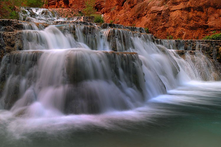
About Pewee Falls
Pewee Falls sits on the Pend Oreille River in northeastern Washington and rewards those who make the trip with a dramatic, scenic drop framed by quiet river canyon habitat. The falls are remote and less frequented than many regional cascades, so the experience leans toward discovery rather than a developed viewpoint. Access is not straightforward, and the approach involves more effort than a typical waterfall stroll, which helps keep crowds low and the setting peaceful. Visitors typically reach Pewee Falls via an informal route — roughly a 2.4-mile out-and-back approach with about 350 feet of elevation gain rated moderate — or by watercraft where conditions allow. Because there is no maintained, official trail to the falls, expect unmarked and uneven terrain; some parties also reach the river by walking along nearby railroad corridors. Respect private property, exercise caution around tracks and cliffs, and come prepared with good shoes, navigation, and the mindset of a backcountry outing.
The Setting
Pewee Falls sits at 2,218 feet along the Columbia River, in the hills of Washington.
Trail & Hike Details
The Approach
The moderate 2.4-mile out-and-back trail gains 350 feet of elevation on the way to the falls.
Trail Description
There is no official, maintained USFS trail to Pewee Falls. The common approach is an informal 2.4-mile out-and-back route with approximately 350 feet of elevation gain and a moderate difficulty rating. The route is unmaintained natural surface with uneven, rocky footing and some steeper sections; portions may require route-finding. Alternate access by boat or along nearby railroad rights-of-way is reported, but these options carry additional safety and legal considerations—travelers should respect private property and use caution near tracks and fast water.
What to Expect
Expect a remote and challenging journey to reach Pewee Falls. The waterfall is surrounded by natural beauty, with views of the Pend Oreille River and forested landscapes. Due to its remote location, it is less crowded than other waterfalls in the region.
Accessibility
The trail is not wheelchair accessible. Uneven terrain and elevation changes require steady footing.
Frequently Asked Questions
🐶 Are Dogs Allowed at Pewee Falls?
❌ Dogs are not allowed
Are There Any Fees or Permits Required?
🆖 No fees required
🏊 Is There Swimming at Pewee Falls?
❌ Swimming is not allowed
When to Visit
Spring and early summer are ideal times to visit, as water flow is typically at its peak due to snowmelt.
Seasonal Access
The best time to visit is Spring, Summer, and Fall. Winter access may be limited.
Safety Information
Visitors should exercise caution when navigating rugged terrain or using the railroad tracks to access the falls. Be aware of potential hazards such as loose rocks, steep slopes, and fast-moving water. Always inform someone of your plans before visiting remote areas.
Current Water Conditions
143,000 ft³/s
Current discharge — how much water is flowing
About average for this time of year
Based on 88 years of record
107.97 ft
Water depth at gauge
7-Day Discharge Trend
What does this mean for your visit?
Flow is about average for this time of year.
About This Gauge
This gauge is on a nearby waterway and may not reflect exact conditions at the falls.
7-Day Flow Outlook
Based on the USGS gauge COLUMBIA RIVER AT INTERNATIONAL BOUNDARY (20 km away).
Today
Moderate
163020 cfs
6/10Tomorrow
Moderate
168166 cfs
6/10Mon
Strong
170647 cfs
7/10Tue
Strong
174008 cfs
7/10Wed
Strong
173030 cfs
7/10Thu
Moderate
144365 cfs
9/10Fri
Moderate
152889 cfs
6/10Best window: Thu — moderate flow, partly sunny (trip score 9/10).
Best time of year: this gauge typically runs highest from early May to early August, peaking in June.
How we calculate this
This is a transparent outlook, not a precise forecast. We take the waterfall's current flow strength (how it ranks against its historical normal for today, from the nearest USGS stream gauge), carry that ranking forward along the gauge's seasonal curve, and nudge it for forecast rain. Confidence is highest for the next day or two and falls further out. Always check official conditions and your own judgment before visiting — high flows can be dangerous.
Know when to go.
Get a free email alert when waterfalls near Metaline Falls hit peak flow. We only send when conditions are worth the trip — no weekly newsletters, no spam.
Weather Forecast
Location & Access
Getting There
Pewee Falls is located near the Pend Oreille River, accessible primarily by boat or via the nearby railroad tracks. There is no established hiking trail leading directly to the falls, and access may require navigating rugged terrain or private property. Visitors should research access routes carefully before planning a trip.
Get Directions on Google MapsParking
There is no designated parking area for Pewee Falls. Visitors may need to park at nearby public access points along the Pend Oreille River or other suitable locations.
Elevation
2,218 feet above sea level
Coordinates
48.970956° N, -117.355031° W
Visitor Tips & Gear
Plan your visit carefully and ensure you have proper navigation tools. Be prepared for rugged terrain and potential challenges in accessing the falls. Bring plenty of water, snacks, and appropriate footwear.
As an Amazon Associate, we earn from qualifying purchases.
With 2.4 miles and 350 ft of elevation gain, sturdy boots and trekking poles will help on this moderate trail. Sun exposure on the trail makes good sun protection a must in summer.

Polarized Sunglasses (Knockaround)
Cuts glare off the water so you actually see the falls — and your photos turn out better too.

Columbia Watertight II Rain Jacket
Packs into its own pocket, seam-sealed, and keeps you dry from spray and surprise rain.

Earth Pak Waterproof Dry Bag
Keeps your phone and gear dry when waterfall mist soaks everything else.

Waterproof Phone Pouch (AiRunTech)
Cheap insurance — take photos right next to the falls without killing your phone.

Timberland Euro Sprint Mid Waterproof
Trusted waterproof boot with premium leather and grippy rubber sole — reliable on rocky, wet trails.

TrailBuddy Trekking Poles
Lightweight aluminum, cork grips, and flip-locks that actually hold — a best-seller for good reason.
Where to Stay

Glenwood Inn & Suites

Crown Columbia Hotel; BW Premier Collection

Genelle House B&B Guest House

Villagers Inn
Browse vacation cabins and private rentals nearby
Unique outdoor stays — tents, yurts, and treehouses
Rent a campervan or RV for your waterfall road trip
Some links are affiliate links. We may earn a commission at no extra cost to you.
Nearby Campground
WEST SULLIVAN
8.2 miles away · 11 sites
Overview West Sullivan Campground is located at the north end of Sullivan Lake and about five miles east of Metaline Falls in northeast Washington. The campground provides a unique environment where campers can enjoy a variety of recreational activities. Recreation The Sullivan Lake Basin provides campers with opportunities for swimming, fishing, boating and hiking. Fishing in this deep mountain lake is most successful from a boat. Common fish species in the lake include burbot (ling cod) and Kok
Book on Recreation.govAdditional Information
Nearby Attractions
Nearby attractions include the Pend Oreille River and other natural areas in northeastern Washington. The area is also known for its wildlife and scenic views.
Wildlife
The region is home to a variety of wildlife, including deer, birds, and other forest animals. Visitors should be cautious of potential encounters with bears or other large animals.
Cities near Pewee Falls
Nearby Waterfalls
Writing about Pewee Falls? Embed this waterfall on your site for free.