Difficulty
Easy
Trail Length
0.6 miles
Trail Type
Out And Back
Elevation Gain
50 ft
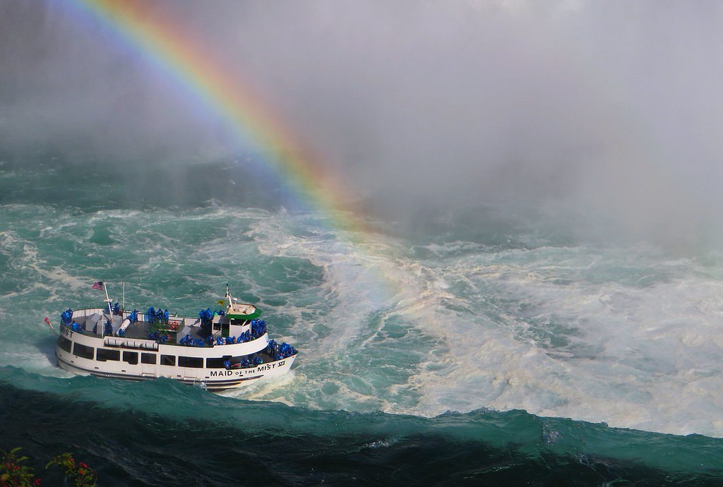
About Peavey Falls
Peavey Falls is a scenic cascade on the Menominee River in Marinette County, Wisconsin, framed by lush forest and a peaceful riverside setting. The falls offer a compact but photogenic series of drops that make for a rewarding short outing — a popular stop for local hikers and nature lovers seeking water vistas without a long trek. The falls sit on the Menominee Reservation (land unit: Menominee Reservation), with the parcel designated TRIB and the land owner listed as DESG; management is handled by the tribal authority (manager: TRIB). While the route to the viewpoint is short and rated easy, visitors should expect simple, natural footpaths and bring appropriate footwear and insect protection for a comfortable visit.
The Setting
Peavey Falls sits at 984 feet within Menominee Reservation, fed by the Red River, in the foothills of Wisconsin.
Trail & Hike Details
The Approach
The easy 0.6-mile out and back trail gains 50 feet of elevation on the way to the falls.
Trail Description
Short out-and-back trail: 0.6 miles with approximately 50 feet of elevation gain. Difficulty: Easy. The route follows an unpaved, natural forest tread to the river overlook; sections can be uneven and may be unmarked in places, so watch your footing and plan for a brief, low-effort hike.
What to Expect
Visitors can expect a peaceful and secluded experience at Peavey Falls. The area is surrounded by dense forest, and the sound of cascading water creates a serene atmosphere. The falls are particularly impressive after periods of rainfall.
Accessibility
The trail is short and relatively flat, but the surface may be uneven. Contact the managing agency for accessibility details.
Frequently Asked Questions
🐶 Are Dogs Allowed at Peavey Falls?
❌ Dogs are not allowed
Are There Any Fees or Permits Required?
🆖 No fees required
🏊 Is There Swimming at Peavey Falls?
❌ Swimming is not allowed
When to Visit
Spring and early summer are ideal times to visit, as the water flow is typically stronger due to snowmelt and rainfall.
Seasonal Access
The best time to visit is Spring, Summer, and Fall. Winter access may be limited.
Safety Information
Exercise caution near the water, as rocks can be slippery and currents may be strong. The area is remote, so visitors should inform someone of their plans and carry a fully charged phone or emergency device.
Current Water Conditions
131 ft³/s
Current discharge — how much water is flowing
About average for this time of year
Based on 33 years of record
5.95 ft
Water depth at gauge
67°F
CoolRefreshing for swimming
7-Day Discharge Trend
What does this mean for your visit?
Flow is about average for this time of year. Water temperature is a refreshing 67 degrees F, good for a quick swim.
About This Gauge
This gauge is on a nearby waterway and may not reflect exact conditions at the falls.
7-Day Flow Outlook
Based on the USGS gauge RED RIVER AT MORGAN ROAD NEAR MORGAN, WI (10 km away).
Today
Low
149 cfs
3/10Tomorrow
Low
157 cfs
3/10Wed
Low
155 cfs
3/10Thu
Low
146 cfs
3/10Fri
Low
145 cfs
3/10Sat
Low
142 cfs
4/10Sun
Low
146 cfs
3/10Best window: Sat — low flow, chance rain showers (trip score 4/10).
Best time of year: this gauge typically runs highest from late March to mid June, peaking in April.
How we calculate this
This is a transparent outlook, not a precise forecast. We take the waterfall's current flow strength (how it ranks against its historical normal for today, from the nearest USGS stream gauge), carry that ranking forward along the gauge's seasonal curve, and nudge it for forecast rain. Confidence is highest for the next day or two and falls further out. Always check official conditions and your own judgment before visiting — high flows can be dangerous.
Know when to go.
Get a free email alert when waterfalls near Middle Village hit peak flow. We only send when conditions are worth the trip — no weekly newsletters, no spam.
Weather Forecast
Location & Access
Getting There
Peavey Falls is located near the town of Pembine, Wisconsin. Access is typically via local roads, and the falls are situated in a relatively remote area. Visitors should use GPS or a detailed map to navigate to the site.
Get Directions on Google MapsParking
Parking is available near the falls, but it may be limited. Visitors should plan accordingly, especially during peak seasons.
Hours
Elevation
984 feet above sea level
Coordinates
44.966087° N, -88.770384° W
Land Management
Managed by TRIB
Visitor Tips & Gear
Bring a map or GPS device as the area is remote and signage may be limited. Wear sturdy footwear and be cautious of slippery rocks near the falls. Cell phone service may be unreliable in the area.
As an Amazon Associate, we earn from qualifying purchases.
For this easy 0.6 miles trail, lightweight trail shoes and a water bottle are usually sufficient. Sun exposure on the trail makes good sun protection a must in summer.

Columbia Watertight II Rain Jacket
Packs into its own pocket, seam-sealed, and keeps you dry from spray and surprise rain.

Earth Pak Waterproof Dry Bag
Keeps your phone and gear dry when waterfall mist soaks everything else.

Waterproof Phone Pouch (AiRunTech)
Cheap insurance — take photos right next to the falls without killing your phone.

Polarized Sunglasses (Knockaround)
Cuts glare off the water so you actually see the falls — and your photos turn out better too.

Osprey Daylite Daypack
Light, organized, and just the right size for a day hike — fits water, snacks, and layers.

OR Sombriolet Sun Hat
UPF 50+ sun protection with vents so your head doesn't cook on exposed trail sections.
Where to Stay

Super 8 by Wyndham Antigo

Sleep Inn Antigo

Holiday Inn Express Hotel & Suites Antigo by IHG

Soak, Relax & Explore! Walk to Wolf River
Browse vacation cabins and private rentals nearby
Unique outdoor stays — tents, yurts, and treehouses
Rent a campervan or RV for your waterfall road trip
Some links are affiliate links. We may earn a commission at no extra cost to you.
Nearby Campground
BOULDER LAKE
13.6 miles away · 99 sites
Overview Boulder Lake Campground is located on the shores of Boulder Lake in northern Wisconsin. It is the forest's largest campground but campsites fill up fast. The campground is home to individual and group sites, making it an ideal location to relax with friends or family. Recreational opportunities abound. Recreation Boulder Lake provides ample opportunities for power boating, water skiing, fishing and swimming. Anglers might catch walleye, northern pike, bass or panfish. Ice fishing is also
Book on Recreation.govAdditional Information
Nearby Attractions
Other waterfalls in Marinette County, such as Long Slide Falls and Twelve Foot Falls, are worth visiting.
Wildlife
The area is home to a variety of wildlife, including deer, birds, and small mammals. Visitors should be cautious of ticks and other insects.
Cities near Peavey Falls
Nearby Waterfalls
Writing about Peavey Falls? Embed this waterfall on your site for free.