Difficulty
Moderate
Trail Length
2.4 miles
Trail Type
Out And Back
Elevation Gain
350 ft
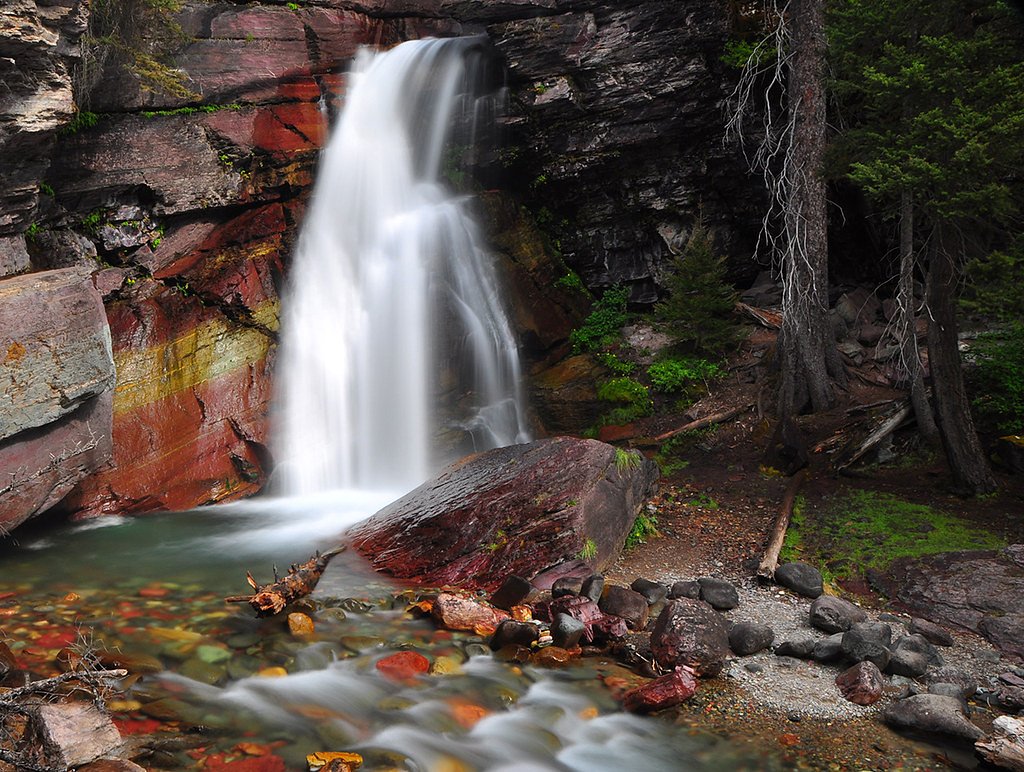
About Patsy Ann Falls
Tucked into Idaho’s Bitterroot National Forest and managed by the U.S. Forest Service, Patsy Ann Falls is a quietly scenic cascade that rewards hikers looking for a peaceful outing. The approach follows Whitecap Creek Trail (USFS Trail #24.0), threading through classic forested terrain and offering a less-crowded alternative to busier waterfall stops. Its secluded setting makes the falls a great choice for visitors seeking a restorative, nature-focused hike. The most common approach to the falls is a moderate 2.4-mile out-and-back hike with about 350 feet of elevation gain. The USFS lists Whitecap Creek Trail #24.0 as Class 3 with a native-material surface and a typical grade of 12–20%; agency GIS data records the trail at 16.63 miles in the system, though the in-and-out visit to Patsy Ann Falls is the shorter 2.4-mile route. Expect a moderate, natural-tread hike with rewarding views at the cascade and the quiet atmosphere of Bitterroot National Forest.
The Setting
Patsy Ann Falls sits at 5,400 feet within Bitterroot National Forest, in the high mountains of Idaho.
Trail & Hike Details
The Approach
The moderate hike follows Whitecap Creek (#24.0), a 2.4-mile out-and-back trail over natural surface. Expect 350 feet of elevation gain with grades of 12-20%. The trail is developed (Class 3).
USFS Trail
WHITECAP CREEK #24.0
Trail Class
Developed
Surface
Avg Grade
USFS Segment
16.63 miTrail Description
Trail: Whitecap Creek (USFS Trail #24.0) — out-and-back to Patsy Ann Falls. Length: 2.4 miles (out-and-back). Elevation gain: ~350 feet. Difficulty: moderate. USFS trail data: Class 3; Surface: NAT (native material); Typical grade: 12–20%; GIS-recorded trail length in the system: 16.63 miles. Conditions: The trail is a native-material tread listed by the USFS as Class 3 with moderate to steep sections (12–20% grade typical). Expect primitive, uneven footing and a mostly natural singletrack; come prepared with sturdy footwear and basic backcountry supplies.
What to Expect
Visitors can expect a tranquil waterfall surrounded by Idaho's natural landscapes. The area may have limited amenities, so plan for a rustic experience.
Accessibility
The trail is not wheelchair accessible. Uneven terrain and elevation changes require steady footing.
Frequently Asked Questions
🐶 Are Dogs Allowed at Patsy Ann Falls?
❌ Dogs are not allowed
Are There Any Fees or Permits Required?
🆖 No fees required
🏊 Is There Swimming at Patsy Ann Falls?
❌ Swimming is not allowed
When to Visit
Spring and early summer are ideal for visiting, as the waterfall is likely to have the strongest flow due to snowmelt.
Seasonal Access
The best time to visit is Spring, Summer, and Fall. Access roads and trails may close during winter due to snow. Check with Bitterroot National Forest for seasonal road closures.
Safety Information
The trail may be unmarked or poorly maintained. Visitors should exercise caution, especially during wet or icy conditions. Always inform someone of your plans before heading out.
Know when to go.
Get a free email alert when waterfalls near Darby hit peak flow. We only send when conditions are worth the trip — no weekly newsletters, no spam.
Weather Forecast
Location & Access
Getting There
The exact directions to Patsy Ann Falls are not widely documented. Visitors are advised to consult local maps or contact nearby ranger stations for guidance.
Get Directions on Google MapsParking
Parking availability is unclear. Visitors should prepare for limited or informal parking options near the trailhead.
Elevation
5,400 feet above sea level
Coordinates
45.959086° N, -114.458149° W
Land Management
Managed by USFS
Visitor Tips & Gear
Bring a detailed map or GPS device as the location is not well-marked. Wear sturdy footwear and be prepared for uneven terrain.
This trail sits at 5,400 ft above sea level
Elevated TrailUV radiation is roughly 22% stronger at this elevation than at sea level, and the dry air accelerates dehydration. Extra sun protection and fluids go a long way.
As an Amazon Associate, we earn from qualifying purchases.

Coppertone Sport SPF 50 Sunscreen
UV intensity jumps ~4% per 1,000 ft — at this elevation you can burn in half the time.

Sun Bum SPF 30 Lip Balm (3-Pack)
Lips have almost no natural UV protection and burn fast in thin, dry mountain air.

Liquid I.V. Electrolyte Packets
You lose moisture ~2x faster at elevation — electrolytes help you absorb water efficiently.

ROCKNIGHT Polarized UV400 Sunglasses
High-altitude glare off rock and water is intense — UV400 lenses block 99%+ of UVA/UVB.
As an Amazon Associate, we earn from qualifying purchases.
With 2.4 miles and 350 ft of elevation gain, sturdy boots and trekking poles will help on this moderate trail. Sun exposure on the trail makes good sun protection a must in summer.

Columbia Watertight II Rain Jacket
Packs into its own pocket, seam-sealed, and keeps you dry from spray and surprise rain.

Earth Pak Waterproof Dry Bag
Keeps your phone and gear dry when waterfall mist soaks everything else.

Waterproof Phone Pouch (AiRunTech)
Cheap insurance — take photos right next to the falls without killing your phone.

Timberland Euro Sprint Mid Waterproof
Trusted waterproof boot with premium leather and grippy rubber sole — reliable on rocky, wet trails.

TrailBuddy Trekking Poles
Lightweight aluminum, cork grips, and flip-locks that actually hold — a best-seller for good reason.

Polarized Sunglasses (Knockaround)
Cuts glare off the water so you actually see the falls — and your photos turn out better too.
Where to Stay

Hannon House

SkyWater Cabins

Cozy Cabin Oxen-Le-Fields Montana

Tent 2 Oxen-Le-Fields Montana
Browse vacation cabins and private rentals nearby
Unique outdoor stays — tents, yurts, and treehouses
Rent a campervan or RV for your waterfall road trip
Some links are affiliate links. We may earn a commission at no extra cost to you.
Nearby Campground
WOODS CABIN
12.6 miles away · 1 sites
Overview Woods Cabin offers a unique chance to camp in the forest, in a rustic, old-time setting, while enjoying all the summer and winter activities that are available from the shore of scenic Lake Como. The cabin provides a comfortable experience and spectacular views, with its large windows and decks overlooking the lake and nearby mountain peaks. It also provides access to the lake and a nearby beach and gives visitors access to a myriad of trails and open spaces. IMPORTANT WINTER RENTAL INFO
Book on Recreation.govNearby Hot Springs
Hot springs near Darby, Idaho
Blue Joint Hot Spring 1
Blue Joint Hot Spring 1 reaches 84°F at 5,031 feet elevation in the Bitterroot National Forest, running 42.5 degrees above ambi...
Blue Joint Hot Springs 2
Blue Joint Hot Springs 2 flows at 84°F at 4,936 feet elevation in Bitterroot National Forest, matching the temperature of its c...
Horse Creek Hot Springs
Horse Creek Hot Springs surfaces at 109°F within the Salmon National Forest at 6,080 feet in Lemhi County, accessible roadside ...
Medicine Hot Springs
Medicine Hot Springs delivers 117°F water on Bitterroot National Forest land in Ravalli County, Montana, with alkaline chemistr...
Prospector Hot Springs
Prospector Hot Springs lies more than six miles from the nearest road in the backcountry near the Selway-Bitterroot Wilderness,...
Running Warm Springs
Running Warm Springs flows at 106 degrees in the Nezperce National Forest at 4,140 feet, carrying some of the most alkaline wat...
Looking for a soak after your hike? Explore more hot springs near Darby, Idaho on SoakingSprings.
Explore Idaho springsAdditional Information
Nearby Attractions
Other natural attractions in Idaho, such as nearby hiking trails or scenic viewpoints, may be worth exploring.
Wildlife
The area may host typical Idaho wildlife, including deer, birds, and small mammals. Be cautious of potential encounters with bears or other larger animals.
Cities near Patsy Ann Falls
Nearby Waterfalls
Writing about Patsy Ann Falls? Embed this waterfall on your site for free.