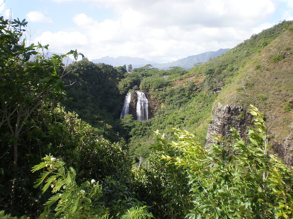
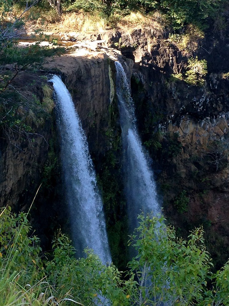
ʻŌpaekaʻa Falls
Hawaii • 151 ft
By Armen Suny · Last verified May 2026
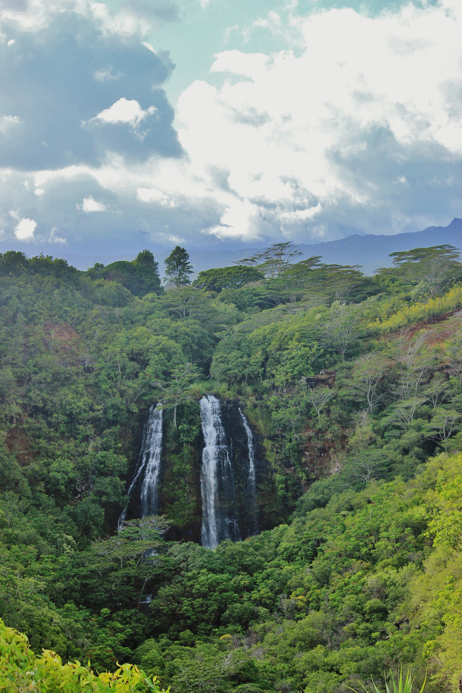
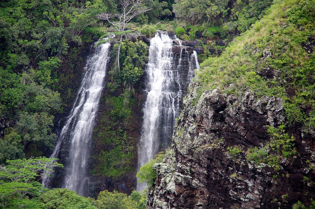
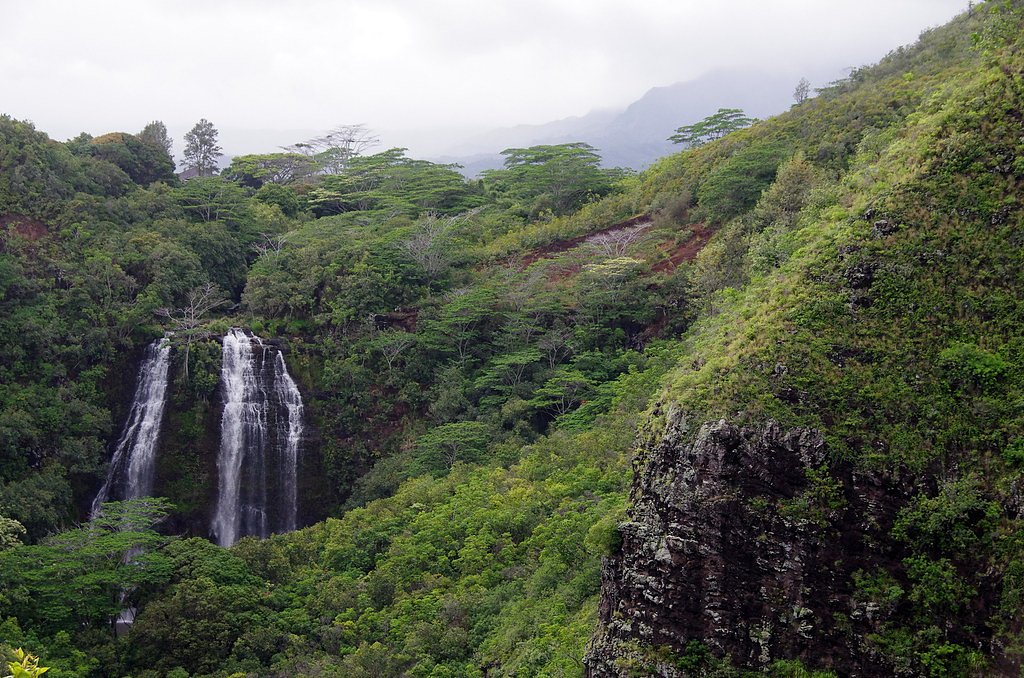
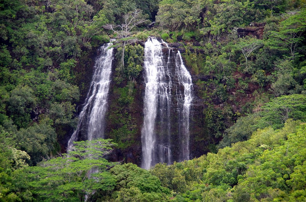

Photo Credits (5)
Difficulty
Drive Up
Trail Length
0.1 miles
Elevation Gain
50 ft
About ʻŌpaekaʻa Falls
ʻŌpaekaʻa Falls is a striking 151-foot (46 m) cascade on the ʻŌpaekaʻa Stream, set in the lush gorge of Wailua River State Park on the eastern shore of Kauai. Nestled within this state park and managed by SPR, the falls are an easy, photogenic stop for visitors driving the island’s scenic roads. The overlook along Kuamoʻo Road offers sweeping views down into the ravine where the water plunges over an ancient volcanic cliff. Beyond the scenic view, the site reveals fascinating geology: the waterfall spills over basalt deposited by volcanic eruptions millions of years ago, and from the ridge you can make out the vertical basalt dikes that cut through the horizontal Koloa lava flows. That dramatic contrast of rock and rainforest makes ʻŌpaekaʻa Falls a memorable and accessible introduction to Kauai’s volcanic landscape.
The Setting
ʻŌpaekaʻa Falls sits at 95 feet within Wailua River State Park, fed by the Sf Wailua River, in the coastal lowlands of Hawaii. At 151 feet, it is among the taller waterfalls in Hawaii.
Height: 151 feet
Trail & Hike Details
The Approach
No hiking required. ʻŌpaekaʻa Falls is accessible by vehicle with a roadside viewing area.
Trail Description
Viewing access: designated lookout point along Kuamoʻo Road; there is no developed trail to the base of the falls. Trail data: length ~0.1 miles, elevation gain ~50 feet, reported difficulty: drive_up. Trail type: unknown. Height of falls: 151 feet. Surface/grade/class: not specified in provided data. The short approach is primarily a roadside overlook rather than a through-hike—plan to park at the turnout and use the marked viewpoint for the best views.
What to Expect
The falls plunge 151 feet.
Accessibility
This waterfall is viewable from a vehicle-accessible area. No hiking is required.
Frequently Asked Questions
🐶 Are Dogs Allowed at ʻŌpaekaʻa Falls?
❌ Dogs are not allowed
Are There Any Fees or Permits Required?
🆖 No fees required
🏊 Is There Swimming at ʻŌpaekaʻa Falls?
❌ Swimming is not allowed
When to Visit
The falls flow year-round, but they are most impressive after heavy rainfall. Morning visits often provide the best lighting for photography.
Seasonal Access
The best time to visit is Spring, Summer, Fall, and Winter. Heavy rains during wet season (November through March) bring higher flow but can make trails slippery.
Safety Information
Stay within designated areas at the lookout to avoid accidents. The area can become slippery during rain, so exercise caution. Do not attempt to hike to the base of the falls, as it is unsafe and not permitted.
Current Water Conditions
78 ft³/s
Current discharge — how much water is flowing
About average for this time of year
Based on 109 years of record
2.84 ft
Water depth at gauge
7-Day Discharge Trend
What does this mean for your visit?
Flow is about average for this time of year.
About This Gauge
7-Day Flow Outlook
Based on the USGS gauge SF Wailua River nr Lihue, Kauai, HI (2 km away).
Today
Moderate
78 cfs
9/10Tomorrow
Strong
47 cfs
8/10Tue
Strong
63 cfs
8/10Wed
Strong
46 cfs
8/10Thu
Strong
65 cfs
8/10Fri
Strong
65 cfs
8/10Sat
Strong
52 cfs
8/10Best window: Today — moderate flow, sunny (trip score 9/10).
Best time of year: this gauge typically runs highest from early November to early December, peaking in December.
How we calculate this
This is a transparent outlook, not a precise forecast. We take the waterfall's current flow strength (how it ranks against its historical normal for today, from the nearest USGS stream gauge), carry that ranking forward along the gauge's seasonal curve, and nudge it for forecast rain. Confidence is highest for the next day or two and falls further out. Always check official conditions and your own judgment before visiting — high flows can be dangerous.
Know when to go.
Get a free email alert when waterfalls near Wailua hit peak flow. We only send when conditions are worth the trip — no weekly newsletters, no spam.
Weather Forecast
Location & Access
Getting There
ʻŌpaekaʻa Falls is easily accessible via Kuamoʻo Road (Highway 580) on the east side of Kauai. The falls are located near Wailua and are visible from a designated lookout point along the road.
Get Directions on Google MapsParking
There is a small parking lot available at the ʻŌpaekaʻa Falls lookout, which is free of charge. Parking may be limited during peak times.
Elevation
95 feet above sea level
Coordinates
22.048214° N, -159.362012° W
Land Management
Managed by SPR
Visitor Tips & Gear
Arrive early in the day to avoid crowds and secure parking. Bring a camera or binoculars for a closer view of the falls. Be cautious near the lookout area, especially during wet weather, as surfaces may be slippery.
As an Amazon Associate, we earn from qualifying purchases.
For this easy 0.1 miles trail, lightweight trail shoes and a water bottle are usually sufficient. Icy conditions are common in winter — traction cleats are a smart addition.

Columbia Watertight II Rain Jacket
Packs into its own pocket, seam-sealed, and keeps you dry from spray and surprise rain.

Polarized Sunglasses (Knockaround)
Cuts glare off the water so you actually see the falls — and your photos turn out better too.

Earth Pak Waterproof Dry Bag
Keeps your phone and gear dry when waterfall mist soaks everything else.

Waterproof Phone Pouch (AiRunTech)
Cheap insurance — take photos right next to the falls without killing your phone.

Kahtoola MICROspikes
Cult-favorite traction cleats that grip ice and wet rock — essential for winter waterfall hikes.

JOBY GorillaPod Starter Kit
Wraps around railings and rocks for long-exposure waterfall shots — no flat surface needed.
Where to Stay

Kauai Shores Hotel

Banyan Harbor Resort

THE ISO HOTEL, Trademark Collection by Wyndham

Kauai Palms Hotel
Browse vacation cabins and private rentals nearby
Unique outdoor stays — tents, yurts, and treehouses
Rent a campervan or RV for your waterfall road trip
Some links are affiliate links. We may earn a commission at no extra cost to you.
Additional Information
Nearby Attractions
Nearby attractions include Wailua River State Park, Fern Grotto, and Kamokila Hawaiian Village.
Wildlife
The area around the falls is home to various tropical birds and native plants. Visitors may also spot freshwater shrimp in nearby streams.
Cities near ʻŌpaekaʻa Falls
Nearby Waterfalls

Writing about ʻŌpaekaʻa Falls? Embed this waterfall on your site for free.