

Photo Credits (1)
Difficulty
Moderate
Trail Length
2.0 miles
Trail Type
Out And Back
Elevation Gain
200 ft
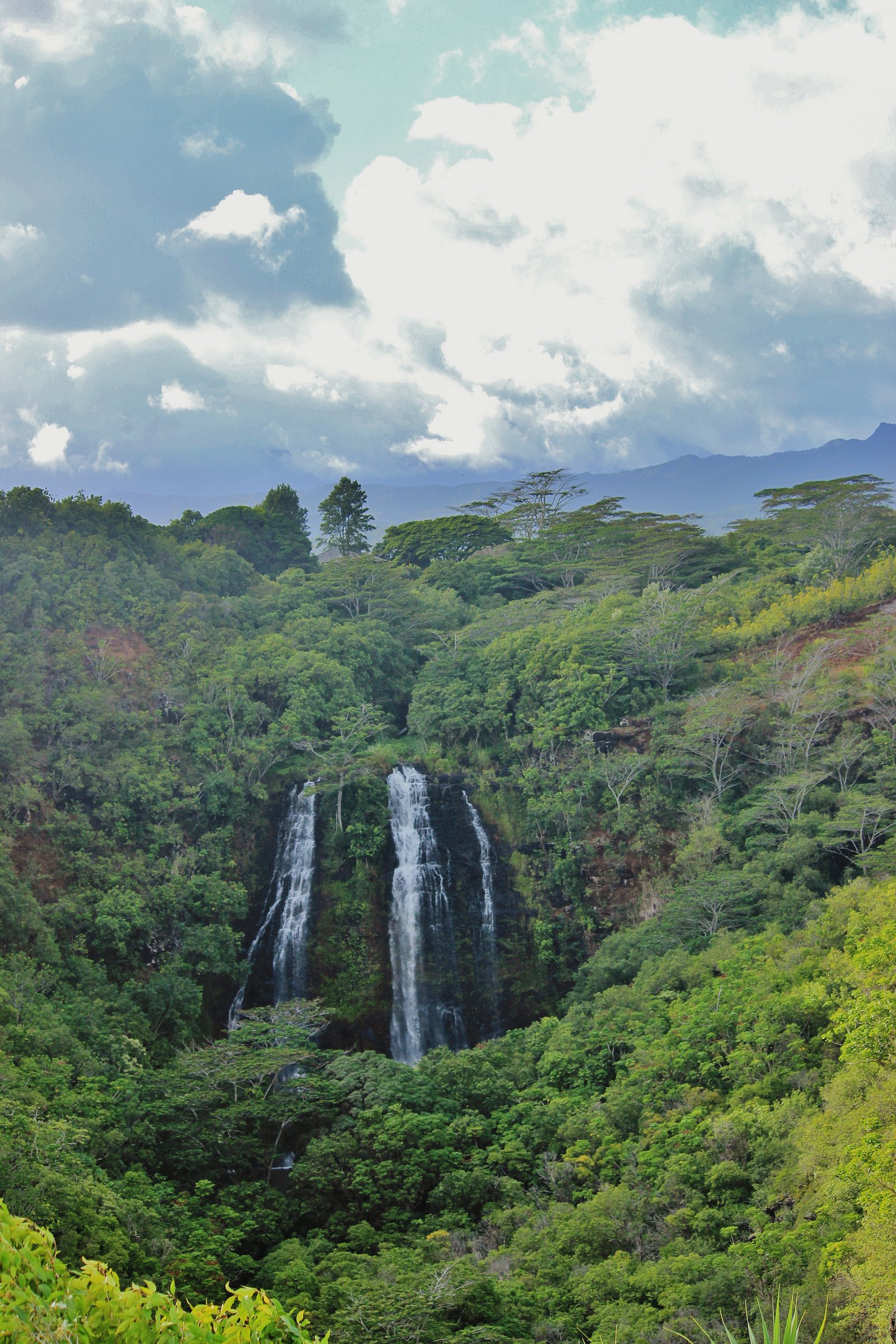
About Hoʻopiʻi Falls
Hoʻopiʻi Falls is a series of scenic cascades on Kapaʻa Stream, tucked near the town of Kapaʻa on the east shore of Kauaʻi. The site features two main drops — a smaller, quieter upper fall and a more dramatic lower fall — set amid lush tropical vegetation that makes it a favorite for day hikers and photographers. The falls also have a bit of cinematic history: they were used as a filming location in Jurassic Park (1993) as the fictional “Mano de Dios Amber Mine.” The falls and the access route sit within a State Department of Land State Resource Management Area (SRMA) and are managed by SDOL. The hiking route to the falls is a moderate, out-and-back outing of about 2.0 miles with roughly 200 feet of elevation gain, making it a satisfying half-day adventure for most fit visitors. Expect dense greenery and a true Hawaiian streamside atmosphere as you approach the pools below the drops.
The Setting
Hoʻopiʻi Falls sits at 75 feet within State Department of Land State Resource Management Area, fed by the Left Branch Opaekaa Str, in the coastal lowlands of Hawaii.
Trail & Hike Details
The Approach
The moderate 2.0-mile out-and-back trail gains 200 feet of elevation on the way to the falls.
Trail Description
The trail to Hoʻopiʻi Falls is an out-and-back route of approximately 2.0 miles with about 200 feet of elevation gain; the overall difficulty is rated moderate. The path travels through dense tropical forest and is primarily a dirt track that can become muddy and slippery after rain, so good footwear is recommended. This route is on SDOL-managed SRMA land (not a USFS trail), so there is no USFS trail number to reference.
What to Expect
Swimming is permitted. Dogs are welcome.
Accessibility
The trail is not wheelchair accessible. Uneven terrain and elevation changes require steady footing.
Frequently Asked Questions
🐶 Are Dogs Allowed at Hoʻopiʻi Falls?
✅ Dogs are allowed
Are There Any Fees or Permits Required?
🆖 No fees required
🏊 Is There Swimming at Hoʻopiʻi Falls?
✅ Swimming is allowed
When to Visit
Morning hours are ideal to avoid crowds and enjoy cooler temperatures. The falls are typically flowing year-round, but water levels may vary depending on recent rainfall.
Seasonal Access
The best time to visit is Spring, Summer, Fall, and Winter. Heavy rains during wet season (November through March) bring higher flow but can make trails slippery.
Safety Information
The trail can be slippery and muddy, especially after rain. Exercise caution near the waterfalls as rocks can be slippery, and the water current may be strong. Avoid swimming during high water levels or after heavy rainfall.
Current Water Conditions
2 ft³/s
Current discharge — how much water is flowing
Higher than usual for this time of year
Based on 66 years of record
0.95 ft
Water depth at gauge
7-Day Discharge Trend
What does this mean for your visit?
The water is flowing higher than usual for this time of year.
About This Gauge
7-Day Flow Outlook
Based on the USGS gauge Left Branch Opaekaa Str nr Kapaa, Kauai, HI (7 km away).
Today
Barely Flowing
2 cfs
5/10Tomorrow
Barely Flowing
3 cfs
3/10Tue
Low
3 cfs
4/10Wed
Low
3 cfs
4/10Thu
Low
3 cfs
4/10Fri
Low
3 cfs
4/10Sat
Low
3 cfs
4/10Best window: Today — barely flowing flow, sunny (trip score 5/10).
Best time of year: this gauge typically runs highest from late November to mid January, peaking in December.
How we calculate this
This is a transparent outlook, not a precise forecast. We take the waterfall's current flow strength (how it ranks against its historical normal for today, from the nearest USGS stream gauge), carry that ranking forward along the gauge's seasonal curve, and nudge it for forecast rain. Confidence is highest for the next day or two and falls further out. Always check official conditions and your own judgment before visiting — high flows can be dangerous.
Know when to go.
Get a free email alert when waterfalls near Kapaa hit peak flow. We only send when conditions are worth the trip — no weekly newsletters, no spam.
Weather Forecast
Location & Access
Getting There
Hoʻopiʻi Falls is located near Kapaʻa on the eastern side of Kauai. Access is via a trailhead on private property, but the trail itself is open to the public. Visitors should park respectfully along the road near the trailhead.
Get Directions on Google MapsParking
Limited roadside parking is available near the trailhead. Visitors should avoid blocking driveways or private property.
Elevation
75 feet above sea level
Coordinates
22.105298° N, -159.339049° W
Land Management
Managed by SDOL
Visitor Tips & Gear
Start your hike early to avoid crowds and heat. Wear sturdy, non-slip shoes as the trail can be muddy and slippery. Bring insect repellent and water. Be respectful of private property near the trailhead.
As an Amazon Associate, we earn from qualifying purchases.
With 2.0 miles and 200 ft of elevation gain, sturdy boots and trekking poles will help on this moderate trail. Icy conditions are common in winter — traction cleats are a smart addition.

Columbia Watertight II Rain Jacket
Packs into its own pocket, seam-sealed, and keeps you dry from spray and surprise rain.

Polarized Sunglasses (Knockaround)
Cuts glare off the water so you actually see the falls — and your photos turn out better too.

Earth Pak Waterproof Dry Bag
Keeps your phone and gear dry when waterfall mist soaks everything else.

Waterproof Phone Pouch (AiRunTech)
Cheap insurance — take photos right next to the falls without killing your phone.

Timberland Euro Sprint Mid Waterproof
Trusted waterproof boot with premium leather and grippy rubber sole — reliable on rocky, wet trails.

TrailBuddy Trekking Poles
Lightweight aluminum, cork grips, and flip-locks that actually hold — a best-seller for good reason.
Where to Stay

Kauai Shores Hotel

THE ISO HOTEL, Trademark Collection by Wyndham

One Bedroom Condo in Pono Kai Resort

Plantation Hale Suites
Browse vacation cabins and private rentals nearby
Unique outdoor stays — tents, yurts, and treehouses
Rent a campervan or RV for your waterfall road trip
Some links are affiliate links. We may earn a commission at no extra cost to you.
Additional Information
Nearby Attractions
Nearby attractions include Kapaʻa town, Keālia Beach, and the Sleeping Giant hiking trail.
Wildlife
The area is home to various bird species and tropical plants. Visitors may also encounter insects and small reptiles.
Cities near Hoʻopiʻi Falls
Nearby Waterfalls
Writing about Hoʻopiʻi Falls? Embed this waterfall on your site for free.