Moretown Falls
By Armen Suny · Last verified May 2026

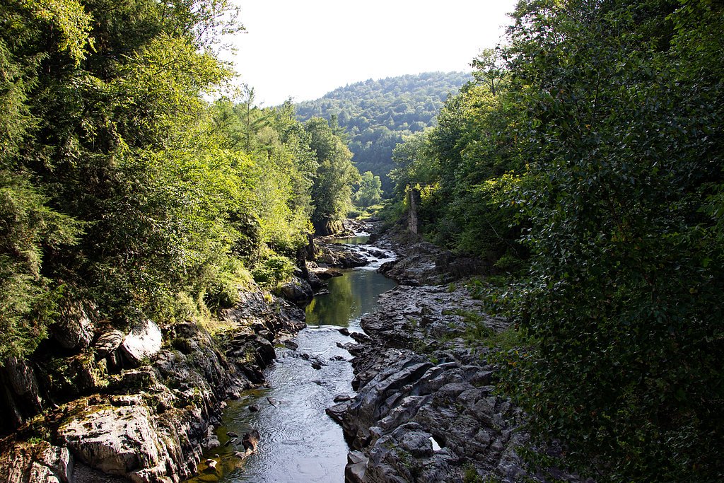

Photo Credits (5)
Difficulty
Easy
Trail Length
0.2 miles
Trail Type
Out And Back
Elevation Gain
50 ft
About Moretown Falls
Moretown Falls is a picturesque waterfall located in Moretown, Vermont, along the Mad River. It is a popular spot for locals and visitors to enjoy the natural beauty of the area, with cascading waters and scenic surroundings.
The Setting
Moretown Falls sits at 571 feet along the Mad River, in the foothills of Vermont.
Trail & Hike Details
The Approach
The easy 0.2-mile out-and-back trail gains 50 feet of elevation on the way to the falls.
Trail Description
No hiking is required to view Moretown Falls as it is visible from the road. Visitors can enjoy the view from the roadside or explore the nearby riverbank with caution.
What to Expect
Dogs are welcome.
Accessibility
The trail is short and relatively flat, but the surface may be uneven. Contact the managing agency for accessibility details.
Frequently Asked Questions
🐶 Are Dogs Allowed at Moretown Falls?
✅ Dogs are allowed
Are There Any Fees or Permits Required?
🆖 No fees required
🏊 Is There Swimming at Moretown Falls?
❌ Swimming is not allowed
When to Visit
Spring and early summer are ideal for visiting Moretown Falls due to higher water levels from snowmelt and rainfall.
Seasonal Access
The best time to visit is Spring, Summer, and Fall. Winter access may be limited.
Safety Information
Exercise caution near the riverbank as rocks can be slippery, and the current may be strong. Avoid visiting during heavy rains or flooding conditions.
Current Water Conditions
271 ft³/s
Current discharge — how much water is flowing
Higher than usual for this time of year
Based on 97 years of record
3.17 ft
Water depth at gauge
7-Day Discharge Trend
What does this mean for your visit?
The water is flowing higher than usual for this time of year.
About This Gauge
7-Day Flow Outlook
Based on the USGS gauge MAD RIVER NEAR MORETOWN, VT (3 km away).
Today
Barely Flowing
271 cfs
5/10Tomorrow
Barely Flowing
246 cfs
4/10Mon
Barely Flowing
238 cfs
5/10Tue
Low
274 cfs
3/10Wed
Moderate
251 cfs
4/10Thu
Moderate
273 cfs
4/10Fri
Moderate
233 cfs
4/10Best window: Today — barely flowing flow, mostly sunny (trip score 5/10).
Best time of year: this gauge typically runs highest from mid March to late May, peaking in April.
How we calculate this
This is a transparent outlook, not a precise forecast. We take the waterfall's current flow strength (how it ranks against its historical normal for today, from the nearest USGS stream gauge), carry that ranking forward along the gauge's seasonal curve, and nudge it for forecast rain. Confidence is highest for the next day or two and falls further out. Always check official conditions and your own judgment before visiting — high flows can be dangerous.
Know when to go.
Get a free email alert when waterfalls near Waterbury Center hit peak flow. We only send when conditions are worth the trip — no weekly newsletters, no spam.
Weather Forecast
Location & Access
Getting There
Moretown Falls is located near Route 100B in Moretown, Vermont. It is easily accessible by car, and the falls are visible from the road.
Get Directions on Google MapsParking
There is limited roadside parking available near the falls. Visitors should exercise caution when parking and ensure they are not blocking traffic.
Elevation
571 feet above sea level
Coordinates
44.251170° N, -72.762061° W
Visitor Tips & Gear
Visit during the spring or after heavy rains for the most impressive water flow. Be cautious of slippery rocks if you choose to explore the riverbank.
As an Amazon Associate, we earn from qualifying purchases.
For this easy 0.2 miles trail, lightweight trail shoes and a water bottle are usually sufficient. Sun exposure on the trail makes good sun protection a must in summer.

Polarized Sunglasses (Knockaround)
Cuts glare off the water so you actually see the falls — and your photos turn out better too.

Columbia Watertight II Rain Jacket
Packs into its own pocket, seam-sealed, and keeps you dry from spray and surprise rain.

Earth Pak Waterproof Dry Bag
Keeps your phone and gear dry when waterfall mist soaks everything else.

Waterproof Phone Pouch (AiRunTech)
Cheap insurance — take photos right next to the falls without killing your phone.

JOBY GorillaPod Starter Kit
Wraps around railings and rocks for long-exposure waterfall shots — no flat surface needed.

Osprey Daylite Daypack
Light, organized, and just the right size for a day hike — fits water, snacks, and layers.
Where to Stay

Grunberg Haus Inn & Cabins

Green Mountain Inn

Crossett Hill Lodge

Fairfield by Marriott Waterbury Stowe
Browse vacation cabins and private rentals nearby
Unique outdoor stays — tents, yurts, and treehouses
Rent a campervan or RV for your waterfall road trip
Some links are affiliate links. We may earn a commission at no extra cost to you.
Additional Information
Nearby Attractions
Nearby attractions include the town of Waterbury, Ben & Jerry's Factory, and Camel's Hump State Park.
Wildlife
The area around Moretown Falls may feature birds, small mammals, and aquatic life in the Mad River.
Cities near Moretown Falls
Nearby Waterfalls
Writing about Moretown Falls? Embed this waterfall on your site for free.