
Photo Credits (5)
Difficulty
Moderate
Trail Length
2.4 miles
Trail Type
Out And Back
Elevation Gain
350 ft
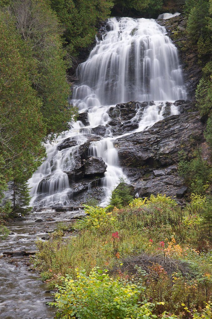
About Moose Falls
Moose Falls is a quiet, photogenic cascade tucked into the shaded woods of northern New Hampshire. The falls sit within the Connecticut Lakes Headwaters forest unit (designation: FORE) and are managed under the unit manager listed as OTHS, giving the site a tucked-away, wild feel that rewards hikers seeking a peaceful nature stop. Framed by mature northern hardwoods and ferny banks, the waterfall is a pleasant destination for photographers and anyone looking for a short, scenic outing. The hike to Moose Falls is an approachable day trip: an out-and-back route of about 2.4 miles with roughly 350 feet of elevation gain, typically rated moderate. The trail’s length and manageable climb make it a good option for hikers with moderate fitness who want a half-day adventure. Trail conditions can vary, so bring sturdy footwear and check local information before you go for the latest access details and any seasonal advisories.
The Setting
Moose Falls sits at 1,969 feet within Connecticut Lakes Headwaters, in the hills of New Hampshire.
Trail & Hike Details
The Approach
The moderate 2.4-mile out-and-back trail gains 350 feet of elevation on the way to the falls.
Trail Description
This is an out-and-back route approximately 2.4 miles in length with about 350 feet of elevation gain and a moderate difficulty rating. The managing land unit is the Connecticut Lakes Headwaters (designation: FORE) under manager OTHS. USFS trail-specific details such as surface type, grade profile, and official trail class are not documented for this route; visitors should expect variable natural footing and consult local resources or trailheads for up-to-date conditions before hiking.
What to Expect
Moose Falls offers a serene natural setting with a small waterfall surrounded by forest. The area may be less crowded compared to other popular waterfalls in New Hampshire.
Accessibility
The trail is not wheelchair accessible. Uneven terrain and elevation changes require steady footing.
Frequently Asked Questions
🐶 Are Dogs Allowed at Moose Falls?
❌ Dogs are not allowed
Are There Any Fees or Permits Required?
🆖 No fees required
🏊 Is There Swimming at Moose Falls?
❌ Swimming is not allowed
When to Visit
Spring and early summer are ideal for visiting, as water flow is typically higher during these seasons.
Seasonal Access
The best time to visit is Spring, Summer, and Fall. Winter access may be limited.
Safety Information
Trail conditions may be uneven or slippery, especially after rain. Visitors should exercise caution and stay on marked paths if available.
Current Water Conditions
Based on a USGS gauge 16 miles away
802 ft³/s
Current discharge — how much water is flowing
Higher than usual for this time of year
Based on 69 years of record
3.58 ft
Water depth at gauge
57°F
ColdBracing — limit time in water
7-Day Discharge Trend
What does this mean for your visit?
The water is flowing higher than usual for this time of year. Water temperature is a bracing 57 degrees F, limit your time in the water.
About This Gauge
This gauge is on a regional waterway. Conditions at the falls may differ, especially after local rain.
7-Day Flow Outlook
Based on the USGS gauge CONNECTICUT R BELOW INDIAN STREAM NR PITTSBURG, NH (26 km away).
Today
Barely Flowing
802 cfs
5/10Tomorrow
Low
894 cfs
3/10Thu
Low
928 cfs
3/10Fri
Low
889 cfs
3/10Sat
Low
885 cfs
3/10Sun
Low
839 cfs
4/10Mon
Low
842 cfs
3/10Best window: Today — barely flowing flow, partly sunny (trip score 5/10).
Best time of year: this gauge typically runs highest from mid December to late February, peaking in January.
How we calculate this
This is a transparent outlook, not a precise forecast. We take the waterfall's current flow strength (how it ranks against its historical normal for today, from the nearest USGS stream gauge), carry that ranking forward along the gauge's seasonal curve, and nudge it for forecast rain. Confidence is highest for the next day or two and falls further out. Always check official conditions and your own judgment before visiting — high flows can be dangerous.
Know when to go.
Get a free email alert when waterfalls near Beecher Falls hit peak flow. We only send when conditions are worth the trip — no weekly newsletters, no spam.
Weather Forecast
Location & Access
Getting There
The exact location and directions to Moose Falls are not well-documented. Visitors are advised to consult local maps or guides for accurate directions.
Get Directions on Google MapsParking
Parking availability is unclear. Visitors may need to park along nearby roads or designated areas if available.
Elevation
1,969 feet above sea level
Coordinates
45.189213° N, -71.192574° W
Land Management
Managed by OTHS
Visitor Tips & Gear
Wear sturdy footwear and bring a map or GPS device, as trail conditions and signage may be unclear. Check weather conditions before visiting.
As an Amazon Associate, we earn from qualifying purchases.
With 2.4 miles and 350 ft of elevation gain, sturdy boots and trekking poles will help on this moderate trail. Sun exposure on the trail makes good sun protection a must in summer.

Polarized Sunglasses (Knockaround)
Cuts glare off the water so you actually see the falls — and your photos turn out better too.

Columbia Watertight II Rain Jacket
Packs into its own pocket, seam-sealed, and keeps you dry from spray and surprise rain.

Earth Pak Waterproof Dry Bag
Keeps your phone and gear dry when waterfall mist soaks everything else.

Waterproof Phone Pouch (AiRunTech)
Cheap insurance — take photos right next to the falls without killing your phone.

Timberland Euro Sprint Mid Waterproof
Trusted waterproof boot with premium leather and grippy rubber sole — reliable on rocky, wet trails.

TrailBuddy Trekking Poles
Lightweight aluminum, cork grips, and flip-locks that actually hold — a best-seller for good reason.
Where to Stay

Le Pèlerin - Chalet rustique Écoresponsable en nature - Estrie

Gîte champêtre Chesham

Chalet Lindsay

Chalet Le RV 3
Browse vacation cabins and private rentals nearby
Unique outdoor stays — tents, yurts, and treehouses
Rent a campervan or RV for your waterfall road trip
Some links are affiliate links. We may earn a commission at no extra cost to you.
Additional Information
Nearby Attractions
Other natural attractions in New Hampshire, such as the White Mountains and various hiking trails, are worth exploring.
Wildlife
The area may feature typical New Hampshire wildlife, including birds, deer, and small mammals.
Cities near Moose Falls
Other waterfalls named Moose Falls
2 other waterfalls share this name across the U.S.
Writing about Moose Falls? Embed this waterfall on your site for free.