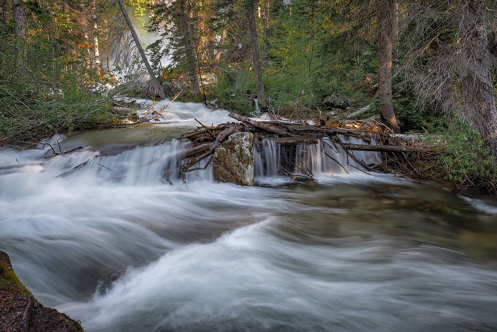
Menace Falls
By Armen Suny · Last verified May 2026
Difficulty
Moderate
Trail Length
2.4 miles
Trail Type
Out And Back
Elevation Gain
350 ft
About Menace Falls
Menace Falls is a tucked-away cascade in Wyoming’s Bridger National Forest, managed by the U.S. Forest Service. The falls are a quieter alternative to more popular viewpoints, sitting amid lodgepole and mixed-conifer forest that rewards hikers seeking solitude and late-summer wildflower displays. Specific measurements for the fall’s height aren’t well-documented, which adds to its backcountry feel: visitors come for the peaceful setting and the sound of water rather than photo-perfect metrics. Access to the falls is primarily via the USFS WY RANGE NAT REC TRAIL (Trail #3048F), and the nearest developed camping is Cazier Cabin campground about 8.48 km away, making overnight trips and early starts feasible for photographers and backpackers. The route and surroundings feel remote but approachable—ideal for moderate hikers who prefer less-trafficked forest streams and rustic scenery.
The Setting
Menace Falls sits at 9,403 feet within Bridger National Forest, in the high alpine of Wyoming.
Trail & Hike Details
The Approach
The moderate hike follows Wy Range Nat Rec Trail (#3048F), a 2.4-mile out-and-back trail over natural surface. Expect 350 feet of elevation gain. The trail is developed (Class 3).
USFS Trail
WY RANGE NAT REC TRAIL #3048F
Trail Class
Developed
Surface
USFS Segment
0.93 miTrail Description
Trail: WY RANGE NAT REC TRAIL (USFS Trail #3048F). The Forest Service lists this trail segment with 0.93 GIS miles mapped; typical visitor routes to Menace Falls cover about 2.4 miles out-and-back with roughly 350 feet of elevation gain. Difficulty: Moderate. Trail class: 3. Surface: native material. Expect a natural tread that can be uneven and occasionally steeper where the grade increases—the Class 3 designation indicates some rougher footing and simple scrambling rather than a smooth, maintained path. The out-and-back route is manageable for most fit hikers but wear sturdy footwear, carry water, and be prepared for variable trail conditions in forested terrain.
What to Expect
Visitors can expect a peaceful and scenic environment with the sound of cascading water. The area may be remote, so it is important to plan ahead and ensure proper preparation.
Accessibility
The trail is not wheelchair accessible. Uneven terrain and elevation changes require steady footing.
Frequently Asked Questions
🐶 Are Dogs Allowed at Menace Falls?
❌ Dogs are not allowed
Are There Any Fees or Permits Required?
🆖 No fees required
🏊 Is There Swimming at Menace Falls?
❌ Swimming is not allowed
When to Visit
Spring and early summer are typically the best times to visit, as snowmelt increases water flow. Fall offers beautiful foliage, while winter access may be limited due to snow.
Seasonal Access
The best time to visit is Spring, Summer, and Fall. Access roads and trails may close during winter due to snow. Check with Bridger National Forest for seasonal road closures.
Safety Information
Visitors should be cautious of slippery rocks near the waterfall and be prepared for remote conditions. Carry a first aid kit and let someone know your plans before heading out.
Current Water Conditions
35 ft³/s
Current discharge — how much water is flowing
Much lower than usual for this time of year
Based on 1 years of record
3.98 ft
Water depth at gauge
7-Day Discharge Trend
What does this mean for your visit?
Flow is well below normal for this time of year, so the waterfall may be a trickle.
About This Gauge
This gauge is on a nearby waterway and may not reflect exact conditions at the falls.
7-Day Flow Outlook
Based on the USGS gauge North Cottonwood Cr bl Halverson Cr, nr Daniel, WY (13 km away).
Today
Low
39 cfs
3/10Tomorrow
Low
40 cfs
3/10Fri
Barely Flowing
34 cfs
5/10Sat
Low
35 cfs
3/10Sun
Low
34 cfs
4/10Mon
Barely Flowing
30 cfs
5/10Tue
Barely Flowing
28 cfs
5/10Best window: Fri — barely flowing flow, mostly sunny (trip score 5/10).
Best time of year: this gauge typically runs highest from late May to early August, peaking in June.
How we calculate this
This is a transparent outlook, not a precise forecast. We take the waterfall's current flow strength (how it ranks against its historical normal for today, from the nearest USGS stream gauge), carry that ranking forward along the gauge's seasonal curve, and nudge it for forecast rain. Confidence is highest for the next day or two and falls further out. Always check official conditions and your own judgment before visiting — high flows can be dangerous.
Know when to go.
Get a free email alert when waterfalls near Afton hit peak flow. We only send when conditions are worth the trip — no weekly newsletters, no spam.
Weather Forecast
Location & Access
Getting There
Menace Falls is located in a remote area of Wyoming. Access may require navigating unpaved roads or trails. Visitors should consult local maps or guides for precise directions.
Get Directions on Google MapsParking
Parking availability is unclear, but visitors may need to park along nearby roads or at designated trailheads if available.
Elevation
9,403 feet above sea level
Coordinates
42.742987° N, -110.614349° W
Land Management
Managed by USFS
Visitor Tips & Gear
Check weather conditions before visiting, as the area may become difficult to access during heavy rain or snow. Bring a map or GPS device, as cell service may be limited.
This trail sits at 9,403 ft — the air is noticeably thinner
High AltitudeSome visitors experience headaches, fatigue, or shortness of breath at this elevation. Take it slow, stay hydrated, and consider supplemental oxygen if you're coming from a lower altitude.
As an Amazon Associate, we earn from qualifying purchases.

Coppertone Sport SPF 50 Sunscreen
UV intensity jumps ~4% per 1,000 ft — at this elevation you can burn in half the time.

Sun Bum SPF 30 Lip Balm (3-Pack)
Lips have almost no natural UV protection and burn fast in thin, dry mountain air.

Liquid I.V. Electrolyte Packets
You lose moisture ~2x faster at elevation — electrolytes help you absorb water efficiently.

ROCKNIGHT Polarized UV400 Sunglasses
High-altitude glare off rock and water is intense — UV400 lenses block 99%+ of UVA/UVB.

Boost Oxygen 10L Canister (2-Pack)
Portable supplemental oxygen for quick relief from headaches and shortness of breath.

Altitude Rx OxyBoost Complex
Antioxidant formula designed to support your body's natural altitude acclimation.
As an Amazon Associate, we earn from qualifying purchases.
With 2.4 miles and 350 ft of elevation gain, sturdy boots and trekking poles will help on this moderate trail. Sun exposure on the trail makes good sun protection a must in summer.

Columbia Watertight II Rain Jacket
Packs into its own pocket, seam-sealed, and keeps you dry from spray and surprise rain.

Earth Pak Waterproof Dry Bag
Keeps your phone and gear dry when waterfall mist soaks everything else.

Waterproof Phone Pouch (AiRunTech)
Cheap insurance — take photos right next to the falls without killing your phone.

Timberland Euro Sprint Mid Waterproof
Trusted waterproof boot with premium leather and grippy rubber sole — reliable on rocky, wet trails.

TrailBuddy Trekking Poles
Lightweight aluminum, cork grips, and flip-locks that actually hold — a best-seller for good reason.

Polarized Sunglasses (Knockaround)
Cuts glare off the water so you actually see the falls — and your photos turn out better too.
Where to Stay

Townhomes on the Green

Mountain Retreat By the River Star Valley Getaway

Fairfield Inn by Marriott Afton Star Valley

Kodiak Mountain Resort
Browse vacation cabins and private rentals nearby
Unique outdoor stays — tents, yurts, and treehouses
Rent a campervan or RV for your waterfall road trip
Some links are affiliate links. We may earn a commission at no extra cost to you.
Nearby Campground
CAZIER CABIN
5.3 miles away · 2 sites
Overview Cazier Cabin is a historic Forest Service guard station built by the Civilian Conservation Corps in 1933. Located near the Greys River about 46 miles from Alpine, Wyoming, the cabin offers fishing, hiking, horseback riding, mountain biking and cross-country skiing opportunities. In winter, access is by snowmobile on a groomed trail. Recreation The Corral Creek Trail is easily accessed from the cabin and connects to Corral Creek Lake and the Swift, Dry and Cottonwood Creek drainages on th
Book on Recreation.govNearby Hot Springs
Hot springs near Afton, Wyoming
Johnson Springs
Johnson Springs emerges at 115 degrees Fahrenheit at 6,080 feet elevation in Lincoln County near Afton, located just 220 feet f...
Auburn Hot Springs
Auburn Hot Springs discharges water at 144°F in Wyoming's Salt River Range, making it one of the state's genuinely scalding the...

Astoria Mineral Hot Springs
Astoria Mineral Hot Springs flows at 99°F from a roadside location 75.9 meters from West Johnny Counts Road in Teton County, Wy...
Granite Falls Hot Springs
This Forest Service-maintained spring produces 112-degree Fahrenheit water at 6,882 feet elevation, accessible via 625-foot wal...

Granite Hot Spring
This spring produces 106-degree Fahrenheit water at 7,035 feet elevation on Forest Service land, emerging 750 feet from the roa...
Alpine Warm Spring
Alpine Warm Spring emerges at 99°F near Hoback at 5,580 feet elevation, maintaining water 55.6°F above ambient in mountain terr...
Looking for a soak after your hike? Explore more hot springs near Afton, Wyoming on SoakingSprings.
Explore Wyoming springsAdditional Information
Nearby Attractions
Nearby attractions are not well-documented, but the surrounding area may offer additional hiking trails and scenic views.
Wildlife
The area may be home to various wildlife, including deer, birds, and small mammals. Visitors should be aware of potential encounters with larger animals such as bears.
Cities near Menace Falls
Nearby Waterfalls
Writing about Menace Falls? Embed this waterfall on your site for free.