Marcella Falls
By Armen Suny · Last verified May 2026
Difficulty
Moderate
Trail Length
2.4 miles
Trail Type
Out And Back
Elevation Gain
350 ft
About Marcella Falls
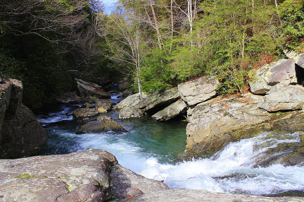
Marcella Falls is a picturesque waterfall located near the Natchez Trace Parkway in Tennessee. It is a serene spot surrounded by natural beauty, often visited by locals and hikers seeking a peaceful retreat.
The Setting
Marcella Falls sits at 853 feet along the Richland Creek, in the foothills of Tennessee.
Trail & Hike Details
The Approach
The moderate 2.4-mile out-and-back trail gains 350 feet of elevation on the way to the falls.
Trail Description
The trail to Marcella Falls is a short and relatively easy hike, making it suitable for most visitors. The path is mostly flat with some uneven terrain, and it leads through a wooded area before reaching the waterfall.
What to Expect
Dogs are welcome.
Accessibility
The trail is not wheelchair accessible. Uneven terrain and elevation changes require steady footing.
Frequently Asked Questions
🐶 Are Dogs Allowed at Marcella Falls?
✅ Dogs are allowed
Are There Any Fees or Permits Required?
🆖 No fees required
🏊 Is There Swimming at Marcella Falls?
❌ Swimming is not allowed
When to Visit
Spring and early summer are ideal times to visit, as the waterfall flow is typically stronger due to seasonal rainfall.
Seasonal Access
The best time to visit is Spring, Summer, and Fall. Winter access may be limited.
Safety Information
Be cautious of slippery rocks near the waterfall. Check weather conditions before visiting, as heavy rain can make the trail muddy and more challenging. Always stay on marked trails to avoid getting lost.
Current Water Conditions
301 ft³/s
Current discharge — how much water is flowing
Higher than usual for this time of year
Based on 16 years of record
6.76 ft
Water depth at gauge
7-Day Discharge Trend
What does this mean for your visit?
The water is flowing higher than usual for this time of year.
About This Gauge
This gauge is on a nearby waterway and may not reflect exact conditions at the falls.
7-Day Flow Outlook
Based on the USGS gauge RICHLAND CREEK AT HWY 64 BYPASS AT PULASKI, TN (23 km away).
Today
Barely Flowing
301 cfs
5/10Tomorrow
Low
373 cfs
3/10Thu
Low
362 cfs
3/10Fri
Low
362 cfs
3/10Sat
Low
404 cfs
3/10Sun
Low
387 cfs
3/10Mon
Low
430 cfs
3/10Best window: Today — barely flowing flow, sunny (trip score 5/10).
Best time of year: this gauge typically runs highest from mid February to mid March, peaking in March.
How we calculate this
This is a transparent outlook, not a precise forecast. We take the waterfall's current flow strength (how it ranks against its historical normal for today, from the nearest USGS stream gauge), carry that ranking forward along the gauge's seasonal curve, and nudge it for forecast rain. Confidence is highest for the next day or two and falls further out. Always check official conditions and your own judgment before visiting — high flows can be dangerous.
Know when to go.
Get a free email alert when waterfalls near Ethridge hit peak flow. We only send when conditions are worth the trip — no weekly newsletters, no spam.
Weather Forecast
Location & Access
Getting There
Marcella Falls is located near Hampshire, Tennessee, and can be accessed via local roads off the Natchez Trace Parkway. Specific directions may vary, so using a GPS or map is recommended.
Get Directions on Google MapsParking
Parking is available near the trailhead, but it may be limited. Visitors should plan to arrive early, especially during weekends or peak seasons.
Elevation
853 feet above sea level
Coordinates
35.363411° N, -87.214457° W
Visitor Tips & Gear
Wear sturdy shoes as the trail may have uneven sections. Bring water and snacks, and consider visiting early in the day to avoid crowds. Be cautious of slippery rocks near the waterfall.
As an Amazon Associate, we earn from qualifying purchases.
With 2.4 miles and 350 ft of elevation gain, sturdy boots and trekking poles will help on this moderate trail. Sun exposure on the trail makes good sun protection a must in summer.

Columbia Watertight II Rain Jacket
Packs into its own pocket, seam-sealed, and keeps you dry from spray and surprise rain.

Earth Pak Waterproof Dry Bag
Keeps your phone and gear dry when waterfall mist soaks everything else.

Waterproof Phone Pouch (AiRunTech)
Cheap insurance — take photos right next to the falls without killing your phone.

Timberland Euro Sprint Mid Waterproof
Trusted waterproof boot with premium leather and grippy rubber sole — reliable on rocky, wet trails.

TrailBuddy Trekking Poles
Lightweight aluminum, cork grips, and flip-locks that actually hold — a best-seller for good reason.

Polarized Sunglasses (Knockaround)
Cuts glare off the water so you actually see the falls — and your photos turn out better too.
Where to Stay

Hampton Inn By Hilton Lawrenceburg

Comfort Suites Columbia I-65

David Crockett Motel

Best Western Plus Lawrenceburg
Browse vacation cabins and private rentals nearby
Unique outdoor stays — tents, yurts, and treehouses
Rent a campervan or RV for your waterfall road trip
Some links are affiliate links. We may earn a commission at no extra cost to you.
Additional Information
Nearby Attractions
The Natchez Trace Parkway offers additional hiking trails and scenic viewpoints. Nearby towns like Columbia and Hampshire provide dining and shopping options.
Wildlife
The area is home to various birds, deer, and other small wildlife. Visitors should be mindful of their surroundings and avoid disturbing the animals.
Cities near Marcella Falls
Nearby Waterfalls
Writing about Marcella Falls? Embed this waterfall on your site for free.