Difficulty
Moderate
Trail Length
2.4 miles
Trail Type
Out And Back
Elevation Gain
350 ft
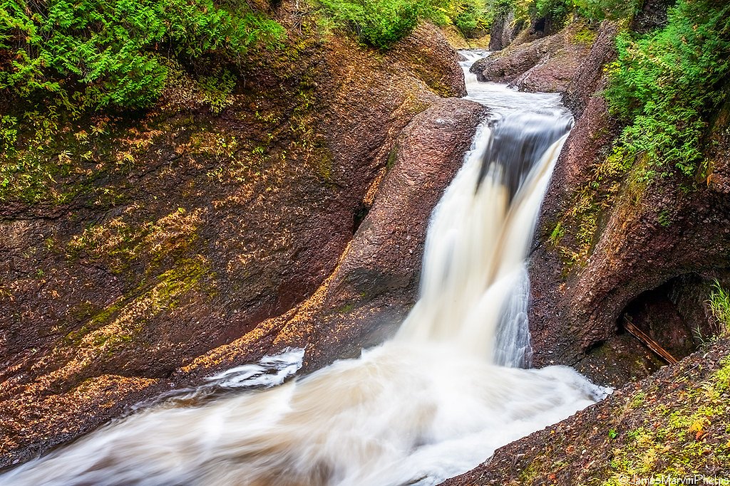
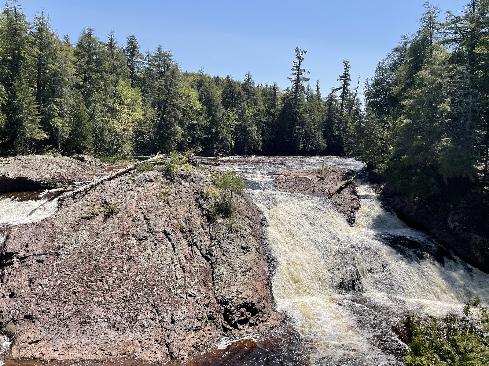
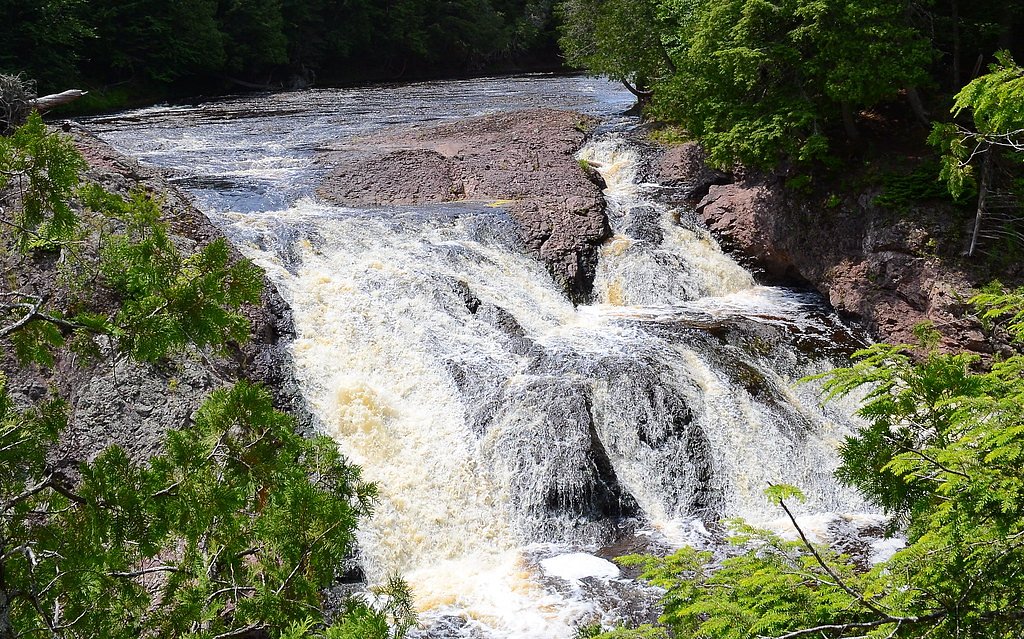
About Manakiki Falls
Manakiki Falls is a lesser-known cascade tucked into Michigan’s forested landscape, offering a quiet, picture-perfect stop for hikers and photographers. The falls are surrounded by lush woods that amplify the sense of seclusion; flows are often strongest after heavy rain or during spring snowmelt, so timing your visit can make a big difference in how dramatic the drop appears. The setting is serene and inviting—ideal for a short nature escape away from busier parks. Access is via a moderate out-and-back hike, and while the route is rewarding, it’s less developed than many trailheads, so expect a more rustic experience. If you’re making an overnight trip of it, camping is available nearby at the Black River Harbor Pavilion, about 5.77 km (3.6 miles) from the falls, which makes a convenient base for exploring the area and catching different light and water conditions at the falls.
The Setting
Manakiki Falls sits at 850 feet along the Presque Isle River, in the foothills of Michigan.
Trail & Hike Details
The Approach
The moderate 2.4-mile out-and-back trail gains 350 feet of elevation on the way to the falls.
Trail Description
The approach to Manakiki Falls is a 2.4-mile out-and-back route with roughly 350 feet of elevation gain, typically rated moderate. Trail information is not widely documented and portions may be unmarked or require some off-trail walking, so hikers should be comfortable with basic navigation and natural tread. No official USFS trail number or detailed surface/grade data is available for this route, so come prepared for uneven footing, roots, and typical forest conditions. Pack water, sturdy footwear, and a map or GPS for a safer visit.
What to Expect
Visitors can expect a peaceful natural setting with a waterfall that may vary in flow depending on the season. The surrounding forest provides a tranquil atmosphere.
Accessibility
The trail is not wheelchair accessible. Uneven terrain and elevation changes require steady footing.
Frequently Asked Questions
🐶 Are Dogs Allowed at Manakiki Falls?
❌ Dogs are not allowed
Are There Any Fees or Permits Required?
🆖 No fees required
🏊 Is There Swimming at Manakiki Falls?
❌ Swimming is not allowed
When to Visit
Spring and early summer are typically the best times to visit, as the waterfall is likely to have the most water flow during these seasons.
Seasonal Access
The best time to visit is Spring, Summer, and Fall. Winter access may be limited.
Safety Information
Visitors should be cautious of slippery rocks, uneven terrain, and potential wildlife encounters. Always let someone know your plans before venturing into less-traveled areas.
Current Water Conditions
91 ft³/s
Current discharge — how much water is flowing
About average for this time of year
Based on 3 years of record
5.50 ft
Water depth at gauge
72°F
ComfortablePleasant for swimming
7-Day Discharge Trend
What does this mean for your visit?
Flow is about average for this time of year. The water is a comfortable 72 degrees F, pleasant for swimming. Expect excellent dissolved oxygen levels. Mineral content is typical.
Water Quality
Dissolved Oxygen
ExcellentSupports aquatic life
Conductance
Dissolved minerals in the water
About This Gauge
This gauge is on a nearby waterway and may not reflect exact conditions at the falls.
7-Day Flow Outlook
Based on the USGS gauge PRESQUE ISLE RIVER NEAR CONNORVILLE, MI (12 km away).
Today
Low
91 cfs
6/10Tomorrow
Moderate
98 cfs
5/10Mon
Moderate
107 cfs
4/10Tue
Moderate
110 cfs
4/10Wed
Moderate
110 cfs
4/10Thu
Moderate
110 cfs
4/10Fri
Moderate
110 cfs
4/10Best window: Today — low flow, mostly sunny (trip score 6/10).
How we calculate this
This is a transparent outlook, not a precise forecast. We take the waterfall's current flow strength (how it ranks against its historical normal for today, from the nearest USGS stream gauge), carry that ranking forward along the gauge's seasonal curve, and nudge it for forecast rain. Confidence is highest for the next day or two and falls further out. Always check official conditions and your own judgment before visiting — high flows can be dangerous.
Know when to go.
Get a free email alert when waterfalls near Bessemer hit peak flow. We only send when conditions are worth the trip — no weekly newsletters, no spam.
Weather Forecast
Location & Access
Getting There
Specific directions to Manakiki Falls are not well-documented. Visitors are advised to consult local maps or guides for the most accurate information.
Get Directions on Google MapsParking
Parking availability near Manakiki Falls is unclear. Visitors may need to park along nearby roads or at designated trailheads if available.
Elevation
850 feet above sea level
Coordinates
46.640835° N, -90.111994° W
Visitor Tips & Gear
Wear sturdy footwear and be prepared for uneven terrain. Check local weather conditions before visiting, as the area may become muddy or slippery after rain.
As an Amazon Associate, we earn from qualifying purchases.
With 2.4 miles and 350 ft of elevation gain, sturdy boots and trekking poles will help on this moderate trail. Sun exposure on the trail makes good sun protection a must in summer.

Columbia Watertight II Rain Jacket
Packs into its own pocket, seam-sealed, and keeps you dry from spray and surprise rain.

Earth Pak Waterproof Dry Bag
Keeps your phone and gear dry when waterfall mist soaks everything else.

Waterproof Phone Pouch (AiRunTech)
Cheap insurance — take photos right next to the falls without killing your phone.

Timberland Euro Sprint Mid Waterproof
Trusted waterproof boot with premium leather and grippy rubber sole — reliable on rocky, wet trails.

TrailBuddy Trekking Poles
Lightweight aluminum, cork grips, and flip-locks that actually hold — a best-seller for good reason.

Polarized Sunglasses (Knockaround)
Cuts glare off the water so you actually see the falls — and your photos turn out better too.
Where to Stay

North Ironwood Acres - Black River Lodge

Snow Otter Haus - 1

Snow Otter Haus - 2

Quality Inn Ironwood
Browse vacation cabins and private rentals nearby
Unique outdoor stays — tents, yurts, and treehouses
Rent a campervan or RV for your waterfall road trip
Some links are affiliate links. We may earn a commission at no extra cost to you.
Nearby Campground
BLACK RIVER HARBOR PAVILION
3.6 miles away · 1 sites
Overview Planning a visit to the Black River Harbor Pavilion? Watch for Alerts at the top of the page for any Alerts regarding this facility. The Black River Harbor Pavilion is located within the Black Harbor Recreation Area on Lake Superior in Michigans Upper Peninsula. The historic stone and wood pavilion was constructed by the Civilian Conservation Corps in the 1930s. Recreation Lake Superior offers great opportunities for boating, fishing, and swimming. The North Country National Scenic Trail
Book on Recreation.govAdditional Information
Nearby Attractions
Other natural attractions in Michigan, such as state parks and hiking trails, may be located nearby.
Wildlife
The area around Manakiki Falls may host a variety of wildlife, including birds, deer, and small mammals. Be cautious and respectful of the local ecosystem.
Cities near Manakiki Falls
Nearby Waterfalls
Writing about Manakiki Falls? Embed this waterfall on your site for free.