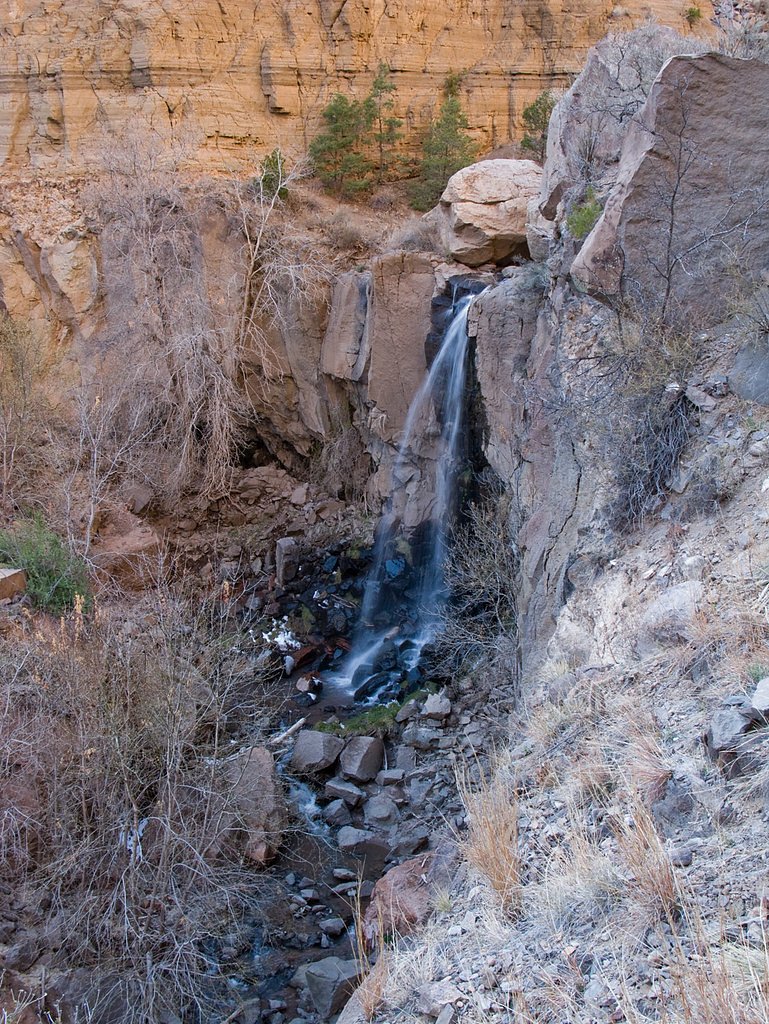
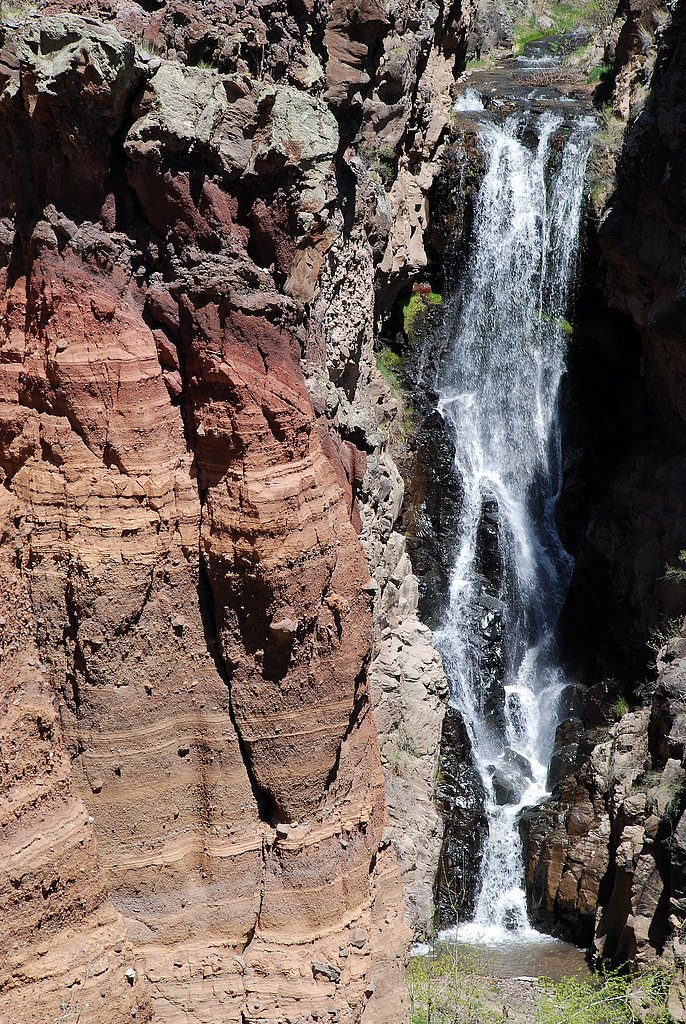
Lower Frijoles Falls
By Armen Suny · Last verified Mar 2026
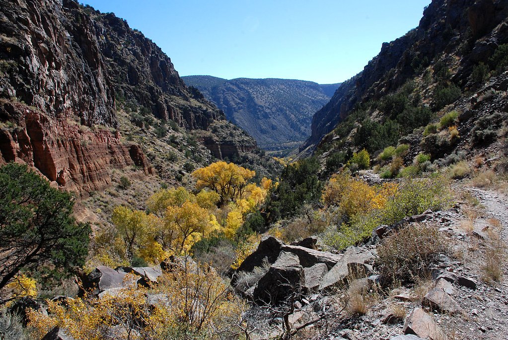
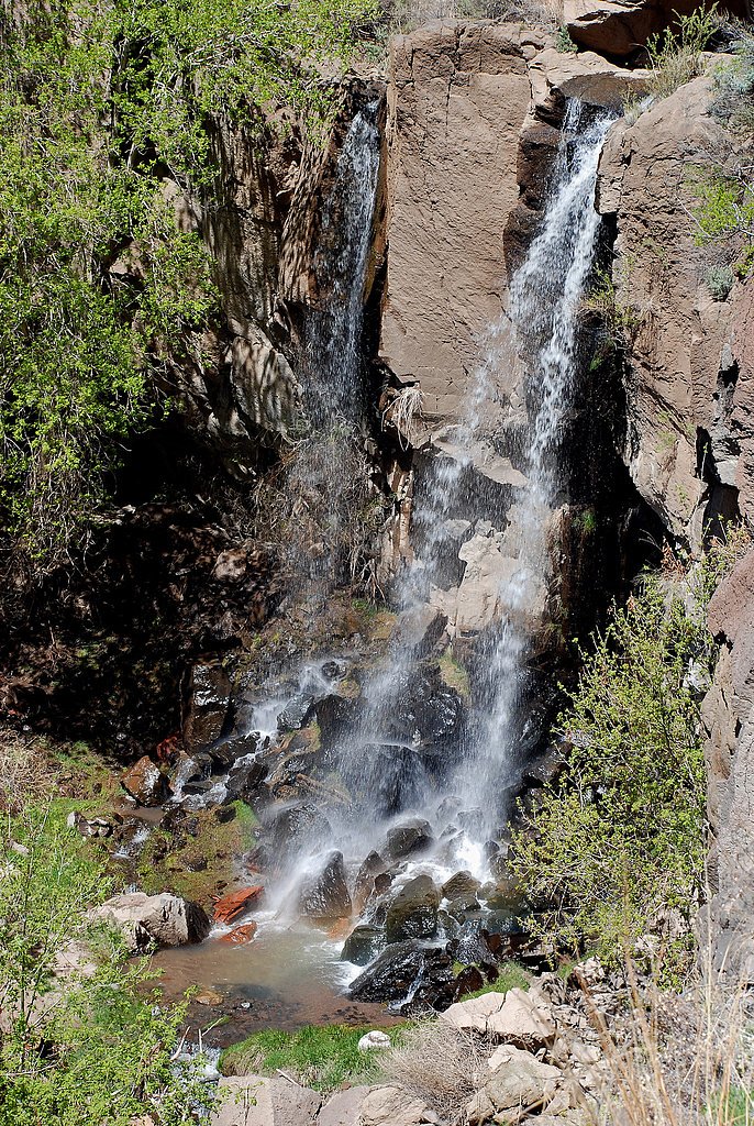
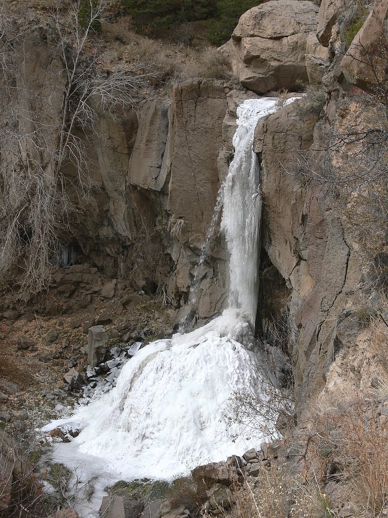
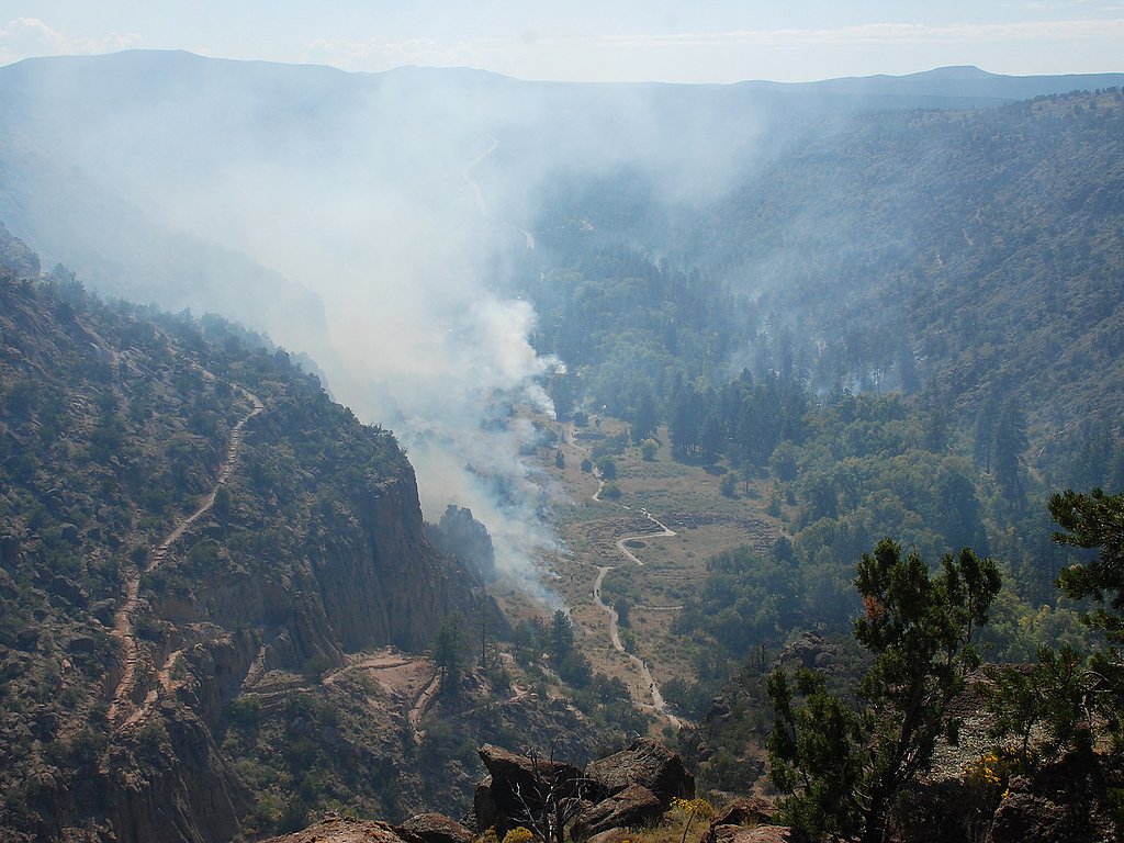

Photo Credits (5)
Difficulty
Moderate
Trail Length
3.0 miles
Trail Type
Out And Back
Elevation Gain
400 ft
About Lower Frijoles Falls
Lower Frijoles Falls is a picturesque waterfall located within Bandelier National Monument in New Mexico. It is part of the Frijoles Creek and cascades into a scenic canyon surrounded by rugged cliffs and desert vegetation.
The Setting
Lower Frijoles Falls sits at 5,725 feet within Bandelier National Monument, in the high mountains of New Mexico.
Trail & Hike Details
The Approach
The moderate 3.0-mile out-and-back trail gains 400 feet of elevation on the way to the falls.
Trail Description
The Falls Trail is a moderately challenging hike that descends into Frijoles Canyon. The trail features scenic views of the canyon, desert flora, and the creek. The path can be rocky and uneven in places, with some steep sections.
What to Expect
Visitors can expect a serene and scenic hike through a desert canyon leading to the waterfall. The falls may have varying water flow depending on the season, with spring and early summer typically offering the best views.
Accessibility
The trail is not wheelchair accessible. Uneven terrain and elevation changes require steady footing.
Frequently Asked Questions
🐶 Are Dogs Allowed at Lower Frijoles Falls?
❌ Dogs are not allowed
Are There Any Fees or Permits Required?
🤑 Fee: $25.00
🏊 Is There Swimming at Lower Frijoles Falls?
❌ Swimming is not allowed
When to Visit
Spring and early summer are the best times to visit, as the water flow is typically higher during these seasons.
Seasonal Access
The best time to visit is Spring, Summer, and Fall. Access roads and trails may close during winter due to snow. Watch for flash flood warnings during monsoon season (July through September). Check the National Park Service website for current conditions.
Safety Information
Be cautious of loose rocks and steep sections on the trail. Avoid hiking during or after heavy rain, as flash flooding can occur in the canyon. Carry sufficient water and be prepared for changing weather conditions.
Current Water Conditions
260 ft³/s
Current discharge — how much water is flowing
Much lower than usual for this time of year
Based on 55 years of record
2.33 ft
Water depth at gauge
78°F
ComfortablePleasant for swimming
7-Day Discharge Trend
What does this mean for your visit?
Flow is well below normal for this time of year, so the waterfall may be a trickle. The water is a comfortable 78 degrees F, pleasant for swimming. Expect murky visibility with reduced clarity.
Water Quality
Water Clarity
MurkyReduced visibility
About This Gauge
This gauge is on a nearby waterway and may not reflect exact conditions at the falls.
7-Day Flow Outlook
Based on the USGS gauge RIO GRANDE AT OTOWI BRIDGE, NM (16 km away).
Today
Moderate
296 cfs
4/10Tomorrow
Moderate
312 cfs
4/10Fri
Moderate
306 cfs
4/10Sat
Moderate
294 cfs
4/10Sun
Moderate
303 cfs
4/10Mon
Moderate
309 cfs
4/10Tue
Moderate
320 cfs
4/10Best window: Today — moderate flow, scattered showers and thunderstorms (trip score 4/10).
Best time of year: this gauge typically runs highest from mid April to early July, peaking in May.
How we calculate this
This is a transparent outlook, not a precise forecast. We take the waterfall's current flow strength (how it ranks against its historical normal for today, from the nearest USGS stream gauge), carry that ranking forward along the gauge's seasonal curve, and nudge it for forecast rain. Confidence is highest for the next day or two and falls further out. Always check official conditions and your own judgment before visiting — high flows can be dangerous.
Know when to go.
Get a free email alert when waterfalls near White Rock hit peak flow. We only send when conditions are worth the trip — no weekly newsletters, no spam.
Weather Forecast
Location & Access
Getting There
Lower Frijoles Falls is accessed via the Falls Trail within Bandelier National Monument. The trailhead is located near the visitor center, which is accessible by car. Visitors should follow the Falls Trail to reach the waterfall.
Get Directions on Google MapsParking
Parking is available at the Bandelier National Monument Visitor Center. A shuttle service may be required during peak seasons.
Elevation
5,725 feet above sea level
Coordinates
35.760860° N, -106.258915° W
Land Management
Managed by NPS
Visitor Tips & Gear
Wear sturdy hiking shoes and bring plenty of water, especially during warmer months. Check weather conditions before visiting, as the trail may be slippery or hazardous after rain. Start early to avoid crowds and heat.
This trail sits at 5,725 ft above sea level
Elevated TrailUV radiation is roughly 23% stronger at this elevation than at sea level, and the dry air accelerates dehydration. Extra sun protection and fluids go a long way.
As an Amazon Associate, we earn from qualifying purchases.

Coppertone Sport SPF 50 Sunscreen
UV intensity jumps ~4% per 1,000 ft — at this elevation you can burn in half the time.

Sun Bum SPF 30 Lip Balm (3-Pack)
Lips have almost no natural UV protection and burn fast in thin, dry mountain air.

Liquid I.V. Electrolyte Packets
You lose moisture ~2x faster at elevation — electrolytes help you absorb water efficiently.

ROCKNIGHT Polarized UV400 Sunglasses
High-altitude glare off rock and water is intense — UV400 lenses block 99%+ of UVA/UVB.
As an Amazon Associate, we earn from qualifying purchases.
With 3.0 miles and 400 ft of elevation gain, sturdy boots and trekking poles will help on this moderate trail. Sun exposure on the trail makes good sun protection a must in summer.
America the Beautiful Annual Pass
Covers entrance fees at 2,000+ federal recreation sites — required at most National Parks.

Polarized Sunglasses (Knockaround)
Cuts glare off the water so you actually see the falls — and your photos turn out better too.

Columbia Watertight II Rain Jacket
Packs into its own pocket, seam-sealed, and keeps you dry from spray and surprise rain.

Earth Pak Waterproof Dry Bag
Keeps your phone and gear dry when waterfall mist soaks everything else.

Waterproof Phone Pouch (AiRunTech)
Cheap insurance — take photos right next to the falls without killing your phone.

Timberland Euro Sprint Mid Waterproof
Trusted waterproof boot with premium leather and grippy rubber sole — reliable on rocky, wet trails.

TrailBuddy Trekking Poles
Lightweight aluminum, cork grips, and flip-locks that actually hold — a best-seller for good reason.
Where to Stay

Hilton Santa Fe Buffalo Thunder

Hampton Inn & Suites Los Alamos

Holiday Inn Express and Suites Los Alamos Entrada Park by IHG

Inn at Vanessie
Browse vacation cabins and private rentals nearby
Unique outdoor stays — tents, yurts, and treehouses
Rent a campervan or RV for your waterfall road trip
Some links are affiliate links. We may earn a commission at no extra cost to you.
Nearby Campground
Juniper Campground (NM)
2.7 miles away · 56 sites
Overview Juniper Family Campground is the ideal place to camp on the Pajarito Plateau. Located just inside the main park entrance, the campground is a short drive from the Bandelier Visitor Center, the Frijoles Canyon Shuttle bus system (mid-May to mid-October), and the adjacent towns of Los Alamos and White Rock. Juniper Family Campground is the perfect "home base" to explore the Pajarito Plateau, Jemez Mountains, and all of north central New Mexico! The campground is divided into 3 loops: Abe
Book on Recreation.govNearby Hot Springs
Hot springs near White Rock, New Mexico
Mccauley Hot Springs
McCauley Hot Springs emerges at 99 °F within Santa Fe National Forest at a notable 7,360 feet elevation in the Jemez Mountains....

Jemez Springs
Jemez Springs reaches 169 degrees Fahrenheit, one of New Mexico's hottest thermal discharges, with USGS measurements confirming...

Soda Dam Hot Springs
Soda Dam Hot Springs consists of fifteen separate thermal vents that have built a massive travertine dam across the Jemez River...

Spence Hot Springs
Spence Hot Springs emerges at 7,332 feet in the Santa Fe National Forest with 100°F water — 52°F above the local average. Total...

Sulphur Springs
Sulphur Springs delivers 189°F water inside the Valles Caldera National Preserve at 8,267 feet elevation -- dangerously hot and...

San Antonio Warm Spring
San Antonio Warm Spring flows at 101°F (38.5°C per USGS) within the Valles Caldera National Preserve at 8,431 feet. The water i...
Looking for a soak after your hike? Explore more hot springs near White Rock, New Mexico on SoakingSprings.
Explore New Mexico springsAdditional Information
Nearby Attractions
Bandelier National Monument also features ancient cliff dwellings, petroglyphs, and the Main Loop Trail, which offers a glimpse into the area's rich history.
Wildlife
Visitors may encounter wildlife such as mule deer, lizards, and various bird species. Be cautious of snakes, especially during warmer months.
Cities near Lower Frijoles Falls
Nearby Waterfalls
Writing about Lower Frijoles Falls? Embed this waterfall on your site for free.