Little Niagara Falls
By Armen Suny · Last verified May 2026
Difficulty
Moderate
Trail Length
7.0 miles
Trail Type
Out And Back
Elevation Gain
400 ft
About Little Niagara Falls
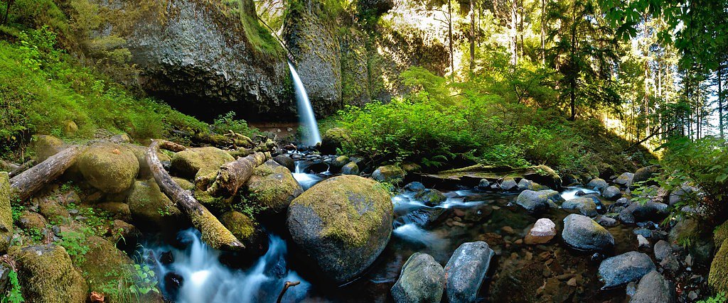
Little Niagara Falls is a compact, photogenic cascade tucked inside Mount Hood National Forest and managed by the U.S. Forest Service. The falls drop into clear, turquoise pools framed by lush, mossy forest; despite its name the site feels tucked away, reached by a very short spur trail off a longer backcountry route. Access to the falls is via the KINZEL LAKE SPUR (Trail #665A), a brief connector that finishes the approach and puts you right at the water's edge. The approach is an enjoyable moderate outing — the full route is about 7.0 miles out-and-back with roughly 400 feet of elevation gain — and the spur to the falls itself is only 0.02 miles. Expect native-material tread and sections that climb at a typical grade of 12–20%; the spur is rated Class 3, so footing can be uneven and slippery after rain. If you want to stay nearby, Camp Creek Campground lies about 7.19 km from the falls for overnight options.
The Setting
Little Niagara Falls sits at 2,162 feet within Mt. Hood National Forest, fed by the Oak Grove Fork, in the hills of Oregon.
Trail & Hike Details
The Approach
The moderate hike follows Kinzel Lake Spur (#665A), a 7.0-mile out-and-back trail over natural surface. Expect 400 feet of elevation gain with grades of 12-20%. The trail is developed (Class 3).
USFS Trail
KINZEL LAKE SPUR #665A
Trail Class
Developed
Surface
Avg Grade
USFS Segment
0.02 miTrail Description
The trail to Little Niagara Falls is part of a roughly 7.0-mile out-and-back route managed by the U.S. Forest Service in Mount Hood National Forest. Total elevation gain is about 400 feet and the route is rated moderate. The falls are reached by the KINZEL LAKE SPUR (Trail #665A), a 0.02-mile connector with a native-material surface and a typical grade of 12–20%. The spur is Class 3—short but uneven—so expect narrow, natural tread and potentially slippery or muddy sections after rain. Overall the approach passes through mature forest, crosses small streams, and finishes at the short but scenic spur to the cascade.
What to Expect
Swimming is permitted. Dogs are welcome.
Accessibility
The trail is not wheelchair accessible. Uneven terrain and elevation changes require steady footing.
Frequently Asked Questions
🐶 Are Dogs Allowed at Little Niagara Falls?
✅ Dogs are allowed
Are There Any Fees or Permits Required?
🤑 Fee: $5.00
Permit required
A Northwest Forest Pass or equivalent is required for parking at the trailhead.
🏊 Is There Swimming at Little Niagara Falls?
✅ Swimming is allowed
When to Visit
Spring and early summer are ideal for visiting, as the waterfall flow is strongest due to snowmelt. Fall offers beautiful foliage, while summer provides warmer weather for hiking.
Seasonal Access
The best time to visit is Spring, Summer, and Fall. Winter access may be limited. Check with Mt. Hood National Forest for seasonal road closures.
Safety Information
Be cautious on slippery rocks near the waterfall. Always stay on marked trails to avoid getting lost. Check weather conditions before your visit, as heavy rain can make the trail hazardous.
Current Water Conditions
67 ft³/s
Current discharge — how much water is flowing
About average for this time of year
Based on 69 years of record
1.56 ft
Water depth at gauge
7-Day Discharge Trend
What does this mean for your visit?
Flow is about average for this time of year.
About This Gauge
This gauge is on a nearby waterway and may not reflect exact conditions at the falls.
7-Day Flow Outlook
Based on the USGS gauge OAK GROVE FORK NEAR GOVERNMENT CAMP, OR (15 km away).
Today
Moderate
72 cfs
6/10Tomorrow
Strong
79 cfs
7/10Sun
Moderate
76 cfs
6/10Mon
Moderate
71 cfs
6/10Tue
Moderate
69 cfs
6/10Wed
Moderate
68 cfs
6/10Thu
Moderate
70 cfs
6/10Best window: Tomorrow — strong flow, showers and thunderstorms (trip score 7/10).
Best time of year: this gauge typically runs highest from mid October to mid November, peaking in November.
How we calculate this
This is a transparent outlook, not a precise forecast. We take the waterfall's current flow strength (how it ranks against its historical normal for today, from the nearest USGS stream gauge), carry that ranking forward along the gauge's seasonal curve, and nudge it for forecast rain. Confidence is highest for the next day or two and falls further out. Always check official conditions and your own judgment before visiting — high flows can be dangerous.
Know when to go.
Get a free email alert when waterfalls near Rhododendron hit peak flow. We only send when conditions are worth the trip — no weekly newsletters, no spam.
Weather Forecast
Location & Access
Getting There
Little Niagara Falls is accessed via the Opal Creek Trailhead, located near the town of Lyons, Oregon. From the trailhead, follow the Opal Creek Trail to reach the falls.
Get Directions on Google MapsParking
Parking is available at the Opal Creek Trailhead, but it can fill up quickly during peak seasons. Arrive early to secure a spot.
Elevation
2,162 feet above sea level
Coordinates
45.241858° N, -121.885986° W
Land Management
Managed by USFS
Visitor Tips & Gear
Wear sturdy hiking shoes, as the trail can be uneven in places. Bring plenty of water and snacks, as there are no facilities along the trail. Arrive early to avoid crowds and secure parking.
As an Amazon Associate, we earn from qualifying purchases.
With 7.0 miles and 400 ft of elevation gain, sturdy boots and trekking poles will help on this moderate trail. Sun exposure on the trail makes good sun protection a must in summer.

Columbia Watertight II Rain Jacket
Packs into its own pocket, seam-sealed, and keeps you dry from spray and surprise rain.

Earth Pak Waterproof Dry Bag
Keeps your phone and gear dry when waterfall mist soaks everything else.

Waterproof Phone Pouch (AiRunTech)
Cheap insurance — take photos right next to the falls without killing your phone.

Timberland Euro Sprint Mid Waterproof
Trusted waterproof boot with premium leather and grippy rubber sole — reliable on rocky, wet trails.

TrailBuddy Trekking Poles
Lightweight aluminum, cork grips, and flip-locks that actually hold — a best-seller for good reason.

Sawyer Squeeze Water Filter
The backcountry standard — filters 99.9% of bacteria and weighs just 3 oz.
Where to Stay

Mount Hood Village

Mt Air Motel

Wallace Cottage - Meredith Lodging

THE CLYDE - Your Cozy & Luxurious Mt Hood Retreat
Browse vacation cabins and private rentals nearby
Unique outdoor stays — tents, yurts, and treehouses
Rent a campervan or RV for your waterfall road trip
Some links are affiliate links. We may earn a commission at no extra cost to you.
Nearby Campground
CAMP CREEK
4.5 miles away · 24 sites
Overview The Camp Creek Campground sits next to a babbling forest creek in the country's scenic Pacific Northwest region. The campground is not far from the base of the majestic, snow-covered Mt. Hood, Oregon's highest point and a prominent landmark of the area. A variety of recreational activities surround the campground, including hiking, biking and horseback riding trails, scenic views and points of exploration.Recreation Surrounding the campground are a variety of hiking and mountain biking t
Book on Recreation.govNearby Hot Springs
Hot springs near Rhododendron, Oregon

Swim Warm Springs
Swim Warm Springs emerges at 79°F within Mount Hood National Forest at 4,063 feet elevation, flowing just 6.9 meters from White...

Mount Hood Fumaroles
Mount Hood Fumaroles vent at 194°F from the flanks of Oregon's highest peak, among the state's most extreme geothermal features...

Austin Hot Springs
Austin Hot Springs discharges at 186°F along the Clackamas River at 1,680 feet elevation, emerging just 310 feet from Clackamas...
Moffetts (Bonneville) Hot Springs
Moffetts Hot Springs, also called Bonneville Hot Springs, flows at 97 degrees in the Gifford Pinchot National Forest at just 75...
Rock Creek Hot Springs
Rock Creek Hot Springs emerges in the Columbia River Gorge in Skamania County, Washington, with water documented as 'hot' witho...

Breitenbush Hot Springs
Breitenbush Hot Springs emerges at 198°F along the Breitenbush River, ranking as one of Oregon's hottest thermal features with ...
Looking for a soak after your hike? Explore more hot springs near Rhododendron, Oregon on SoakingSprings.
Explore Oregon springsAdditional Information
Nearby Attractions
Nearby attractions include Opal Pool, Jawbone Flats, and other waterfalls along the Opal Creek Trail.
Wildlife
The area is home to a variety of wildlife, including birds, deer, and small mammals. Be cautious of insects and ticks during warmer months.
Cities near Little Niagara Falls
Nearby Waterfalls

Other waterfalls named Little Niagara Falls
3 other waterfalls share this name across the U.S.
Writing about Little Niagara Falls? Embed this waterfall on your site for free.